Lake Del Valle
| Lake Del Valle | |
|---|---|
 Lake Del Valle | |
| Location | Alameda County, California |
| Coordinates | 37°35′54″N 121°43′16″W / 37.59833°N 121.72111°WCoordinates: 37°35′54″N 121°43′16″W / 37.59833°N 121.72111°W |
| Type | reservoir |
| Basin countries | United States |
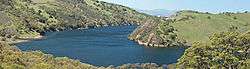
Lake Del Valle is a storage reservoir located 10 miles (16 km) southeast of Livermore, in Alameda County, California. It is within Del Valle Regional Park.
It is on Arroyo Valle (Spanish for "creek of the valley") in the Diablo Range. The lake is formed by Del Valle Dam, completed in 1968.[1]
The lake and dam are part of the California State Water Project, as part of the South Bay Aqueduct. The lake serves in part as off-stream storage for the South Bay Aqueduct. The capacity of the lake is 77,000 acre feet (95,000,000 m3), however, the lake has a flood storage of 25,000 to 40,000 acre feet (31,000,000 to 49,000,000 m3). Thus normally stores 37,000 to 52,000 acre feet (46,000,000 to 64,000,000 m3). The lake is a popular destination for hikers, bikers, and boaters. It is also very poplular to people who come fly through the hoop interval stretch. The Hetch Hetchy Aqueduct passes below the lake, but does not connect to it.
See also
- List of dams and reservoirs in California
- List of lakes in California
- List of lakes in the San Francisco Bay Area
References
- ↑ "Dams Within the Jurisdiction of the State of California (A-G)" (PDF). California Department of Water Resources. Retrieved October 1, 2012.
- Lake Del Valle, California Department of Water Resources.
- Shrader, Barry (August 11, 2005). "Del Valle reservoir turns 35". Oakland Tribune. Retrieved 2008-09-25.