Lake Alice, Manawatu-Wanganui
| Lake Alice | |
|---|---|
| Meshblock | |
|
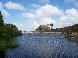
View of Lake Alice, the meshblock's namesake | |
 Lake Alice | |
| Coordinates: 40°07′32″S 175°20′12″E / 40.12556°S 175.33667°ECoordinates: 40°07′32″S 175°20′12″E / 40.12556°S 175.33667°E | |
| Country |
|
| Region | Manawatu-Wanganui |
| Territorial authority | Rangitikei District |
| Named for | Lake Alice |
| Government | |
| • Mayor | Andy Watson |
| • MP | Ian McKelvie |
| Population (2013 census[1]) | |
| • Total | 2,724 |
Lake Alice is a meshblock located in the southwestern part of Rangitikei District of the Manawatu-Wanganui region of New Zealand's North Island. According to the 2013 census, it had a population of 2,724 inhabitants.
History

Lake Alice used to be serviced by Lake Alice Hospital, a self-sufficient rural psychiatric facility. Former patients of the hospital's child and adolescent unit made allegations of abuse during the 1970s, including the use of electroconvulsive therapy and paraldehyde injections as punishment.[2] The New Zealand government issued a written apology in 2001, and paid out a total of NZ$10.7 million in compensation to 183 former patients.[3][4] The former head of the unit gave up the practice of medicine in 2006 in order to forestall a disciplinary hearing by the Medical Practitioners Board of Victoria.[4] The facility ran between August 1950 and October 1999.
Geography
The Lake Alice meshblock is a geographic area which encompasses a mostly rural area sparsed with a few small townships; these are: Crofton, Santoft, Turakina and Whangaehu. Lake Alice envelops Marton, Ratana Community and Koitiata.[5]
Lake Alice has the following boundaries: Pohonui-Porewa meshblock to the north and northeast, Tokorangi-Hiwinui meshblock (Manawatu) to the east, Oroua Downs-Waitohi meshblock (Manawatu) to the southeast and south, Bulls to the southeast, the Tasman Sea to the southwest and west and Fordell-Kakatahi meshblock (Whanganui) to the northwest.[5]
Lake Alice's namesake is Lake Alice, an 11 hectare lake, located just southeast of the centre of the Lake Alice meshblock.
Government and politics
Local government
As part of the Rangitikei District, the current Mayor of Rangitikei since 2013 is Andy Watson.[6]
Lake Alice forms part of the Turakina ward and the Marton ward of the Rangitikei District Council, which elect one and four, respectively, of the eleven district councillors. The one representative of the Turakina ward is Soraya Peke-Mason. The four councillors of the Marton ward are Cath Ash, Nigel Belsham, Mike Jones and Lynne Sheridan.[7] The mayor and councillors are all due for re-election in October 2016.[8]
National government
Lake Alice, like the rest of the Rangitikei District, is located in the general electorate of Rangitīkei and in the Māori electorate of Te Tai Hauāuru.[9] Rangitīkei is a safe National Party seat since the 1938 election with the exception of 1978–1984 when it was held by Bruce Beetham of the Social Credit Party. Since 2011 it is held by Ian McKelvie.[10]
Te Tai Hauāuru is a more unstable seat, having been held by three different parties since 1996, i.e. New Zealand First, the Māori Party and the Labour Party.[11] Since 2014 it is held by Adrian Rurawhe of the Labour Party.[12]
Education
There are two primary schools located in the Lake Alice meshblock: Turakina School in Turakina and Whangaehu School in Whangaehu. The nearest secondary schools are Nga Tawa Diocesan School and Rangitikei College in Marton.
Demographics
| Historical population | ||
|---|---|---|
| Year | Pop. | ±% p.a. |
| 2001 | 2,730 | — |
| 2006 | 2,694 | −0.27% |
| 2013 | 2,724 | +0.16% |
| Source: [1] | ||
Lake Alice had a population of 2,724 according to the 2013 census. This is an increase of 30, or 1.1 percent, since the 2006 census. There were 1,068 occupied dwellings, 126 unoccupied dwellings, and 9 dwellings under construction.[1]
Of the residential population, 1,392 (51.1%) were male compared to 48.7% nationally, and 1,335 (48.9%) were female, compared to 51.3% nationally. The district had a median age of 43.0 years, 5.0 years above the national median age of 38.0 years. People aged 65 and over made up 14.5% of the population, compared to 14.3% nationally, and people under 15 years made up 21.3%, compared to 20.4% nationally.[1]
The meshblock's ethnicity is made up of (national figures in brackets): 91.3% European (74.0%), 13.7% Māori (14.9%), 0.7% Asian (11.8%), 0.9% Pacific Islanders (7.4%), 0.1% Middle Eastern, Latin American or African (1.2%), and 2.3% Other (1.7%).[1]
Lake Alice had an unemployment rate of 3.9% of people 15 years and over, compared to 7.4% nationally. The median annual income of all people 15 years and over was $30,400, compared to $28,500 nationally. Of those, 35.3% earned under $20,000, compared to 38.2% nationally, while 26.6% earned over $50,000, compared to 26.7% nationally.[1]
Transport
Roads
State Highway 1 ![]() goes through the eastern part of the meshblock, beginning just after Bulls and continuing further into Pohonui-Porewa meshblock. The North Island portion of this national state highway, one of only eight in New Zealand, begins at Cape Reinga and ends at Wellington International Airport.
goes through the eastern part of the meshblock, beginning just after Bulls and continuing further into Pohonui-Porewa meshblock. The North Island portion of this national state highway, one of only eight in New Zealand, begins at Cape Reinga and ends at Wellington International Airport.
State Highway 3 ![]() passes through the area from the northwest to the southeast. This highway connects Woodville (25 km east of Palmerston North) and Hamilton via New Plymouth.
passes through the area from the northwest to the southeast. This highway connects Woodville (25 km east of Palmerston North) and Hamilton via New Plymouth.
Public transport
InterCity runs three daily and six non-daily services at the following stops: Lake Alice, Ratana Turn Off, Turakina. These include Palmerston North–Auckland, Wellington–New Plymouth and Auckland–Palmerston North.[13]
The area used to be serviced by the North Island Main Trunk (or Overlander), a railway line connecting Auckland and Wellington. However, in 2012 the Overlander was replaced by the Northern Explorer, which has fewer stops and does not stop in Lake Alice.
The nearest airports to the town are Whanganui Airport, located 15 km west of Whangaehu, and Palmerston North Airport, located 38 km southeast from Lake Alice Hospital. Both airports are domestic only.
References
- 1 2 3 4 5 6 "2013 Census QuickStats about a place: Lake Alice". Statistics New Zealand. Retrieved 2 February 2016.
- ↑ Murphy, Padraic (July 11, 2003). "Probe on Shock Doctor Claims". The Age. Retrieved 2007-04-01.
- ↑ Johnson, Martin (August 29, 2006). "Psychiatrist Must Pay $55,000 After Sex Abuse Case". The New Zealand Herald. Retrieved 2007-04-01.
- 1 2 Johnson, Martin (July 21, 2006). "Lake Alice Doctor Pre-empts Tribunal". The New Zealand Herald. Retrieved 2007-04-01.
- 1 2 "2013 Census map – QuickStats about a place – Lake Alice". Statistics New Zealand. Retrieved 2 February 2016.
- ↑ Wallis, Anna (14 October 2013). "Watson wins Rangitikei chain". Wanganui Chronicle – nzherald.co.nz. Retrieved 1 February 2016.
- ↑ "Councillors". Rangitikei District Council. Retrieved 2 February 2016.
- ↑ "Local Electoral Act 2001". Parliamentary Counsel Office. Retrieved 2 February 2016.
- ↑ "Find my Electorate". Electoral Commission. Retrieved 1 February 2016.
- ↑ "Rangitīkei Electorate Profile". New Zealand Parliament. 30 September 2012. Retrieved 1 February 2016.
- ↑ "Te Tai Hauāuru Electorate Profile". New Zealand Parliament. 30 September 2012. Retrieved 1 February 2016.
- ↑ "Rurawhe, Adrian". New Zealand Parliament. 4 December 2015. Retrieved 1 February 2016.
- ↑ "Ratana Turn Off – Bus Timetable". InterCity. 2 February 2016. Retrieved 2 February 2016.
See also
The Rangitikei District, Manawatu-Wanganui, New Zealand | |||||||||||||
|---|---|---|---|---|---|---|---|---|---|---|---|---|---|
| Main towns and meshblocks | |||||||||||||
| Minor towns and localities | |||||||||||||
| Schools |
| ||||||||||||
| Electorates |
| ||||||||||||
| Members of Parliament |
| ||||||||||||
| Mayor (Council) |
| ||||||||||||
| Bodies of water | |||||||||||||
| Transportation | |||||||||||||
| Other | |||||||||||||