Kryvyi Rih
| Kryvyi Rih (Кривий Ріг) Krivoy Rog (Кривой Рог) | |||
|---|---|---|---|
| City of regional significance | |||
|
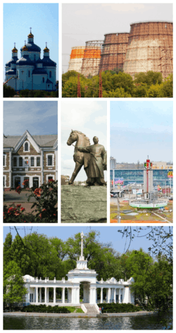
From upper left: Savior Transfiguration Cathedral, ArcelorMittal, Kryvyi Rih Main Station, Maksyma Hor'koho Square, Saksahan boat station | |||
| |||
| Motto: Life-long city | |||
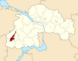 Location in Dnipropetrovsk Oblast | |||
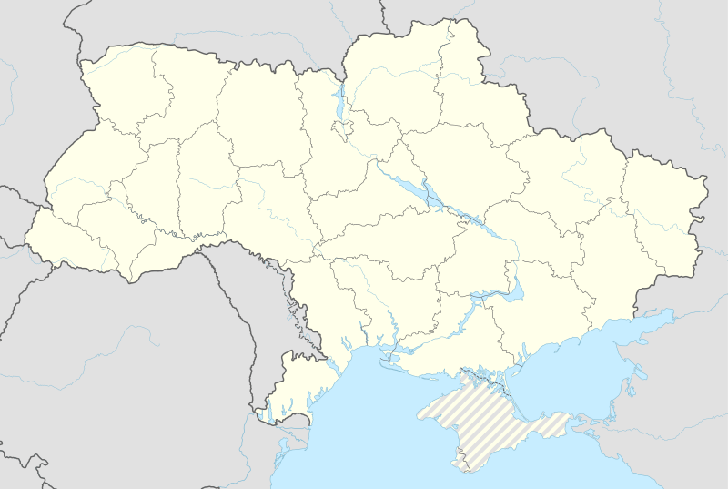 Kryvyi Rih (Кривий Ріг) Location of Kryvyi Rih in Ukraine | |||
| Coordinates: 47°55′0″N 33°15′0″E / 47.91667°N 33.25000°ECoordinates: 47°55′0″N 33°15′0″E / 47.91667°N 33.25000°E | |||
| Country |
| ||
| Province |
| ||
| District |
| ||
| Historic Governorates |
Kherson Yekaterinoslav | ||
| Founded | 1775 (241 years ago) | ||
| Town charter | 1860 | ||
| City status | 1919 | ||
| Administrative HQ |
Kryvyi Rih City Hall, Radianska Square | ||
| Raions |
List of 7
| ||
| Government | |||
| • Type | City council, regional | ||
| • Governing body | Kryvyi Rih City Council | ||
| • Mayor | Yuriy Vilkul[1] | ||
| • MPs: |
Yuri Pavlov Andriy Halchenko Konstantin Usov (PPB) | ||
| Area | |||
| • Total | 410 km2 (160 sq mi) | ||
| Elevation[2] | 84 m (276 ft) | ||
| Population (2014 est.) | |||
| • Total | 654,900 | ||
| • Rank | 8th, UA | ||
| • Density | 1,600/km2 (4,100/sq mi) | ||
| Demonym(s) | Kryvorizhanyn, Kryvorizhanka, Kryvorizhtsi | ||
| Time zone | EET (UTC+2) | ||
| • Summer (DST) | EEST (UTC+3) | ||
| Postal code | 50000-50479 | ||
| Area code | +380 56(4) | ||
| Website |
www | ||
Kryvyi Rih (Ukrainian: Кривий Ріг [krɪˈβɪi̯ rix];,[3] Crooked Horn) or Krivoi Rog (Russian: Кривой Рог [krʲɪˈvoj ˈrok]) is a city in the Dnipropetrovsk region of Ukraine; it is the 8th most populous city in the country.[4] It lies within a large urban area, administratively incorporated with Kryvyi Rih Municipality as a city of region significance. It also serves as the administrative center of the district although it is not part of it. The city extends for 126 km from north to south.
Standing on the Saksahan and Inhulets river, Kryvyi Rih has been a major settlement for most of its history, going back to its founding as a postal city in 1775 by the Cossacks. A military settlement until 1860, it formed part of Kherson, although it was incorporated during the 20th century with areas of Yekaterinoslav. The township began to expand "at an astonishing rate" at the beginning of the 1880s. Kryvyi Rih's urbanization was unplanned; French and English investment arrived due to a boom in metallurgy, iron mining and investigation of rich deposits of iron ore. The building of the Yekateryninska Railway in 1884 – built for transportation of ore to the Donbas – transformed Kryvyi Rih into a major industrial town that culminated in city status in 1919. Nationalization and investment spurred by Soviet authorities led to extensive growth. In 1934 Kryvorizhstal was built, the first of more than 500 factories. The city also gave rise to the foundation of Kryvyi Rih National University. Financially, the city's growth after the Nazi occupation increased due to economic reforms. Also, investment spurred by Ukrainian Independence, market economy and the 2014 revolution led to extensive regeneration, particularly in the city centre.
As of 2016 Kryvyi Rih is arguably the main steel-industry city of Eastern Europe, being a large globally important centre of the iron-ore mining and metallurgy region – the Kryvbas. Its oblast economy is the third-largest in Ukraine.[5]
History
Etymology
The city was founded in the 18th century by Zaporozhian Cossacks. Kryvyi Rih in Ukrainian literally means Crooked Horn. According to local legend, the city was founded by a crooked (Ukrainian slang for one-eyed) Cossack named Rih.[6] However, records pre-dating the existence of the city refer to the area by the same name, due to the shape of the landmass formed by the merging of the river Saksahan into the Inhulets.
Early history
Ingulets Palanka (Zaporizhian Sich administrative division) was established in 1734, and a list of villages and winterings from that time mentions Kryvyi Rih. In 1770[7] the camp of Zaporizhian Sich was founded,[8] and four years later Johann Anton Güldenstädt visited the area and made its first scientific description. On May 8, 1775, after the end of the Russian-Turkish War, Russian authorities opened a postal station and track which linked Kremenchuk, Kinburn foreland and Ochakov, all locations of the Imperial Russian Army. The station was tended by 5 cossacks. Kryvyi Rih entered the 1800s as a village,[9] the largest industrial enterprises of the town being 3 water mills. The first original stone houses were built in 1828,[10] and the highest building at the end of the 1800s was the Central Synagogue, torn down in 1947. The village became a township in 1860.[11]
Industrial growth
Alexander Pol discovered and initiated iron ore investigation and production,[12][13] and this in turn caused the formation of a mining district.[14] In 1874 Alexander II initiated the founding project of a railway,[15] running 505 km. This enabled transportation right into the nearest factories and greatly sped up the development of the region. In 1880, with 5 million francs of capital, Paul founded the "French Society of Kryvyi Rih Ores". In 1882 16.4 thousand tons of ore were extracted from the outskirts by 150 workers. A centre of capitalism, the region was the greatest area of ore extraction in Russia, and the first underground mine of the basin began to function in 1886.[16] A new branch of industry – metallurgy – was founded in 1892, when the first blast furnace of Hdantsivka Ironworks was started.
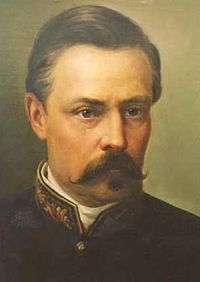 Olexander Paul studied in detail the iron ore and proved its commercial value
 Ore quarry in 1899
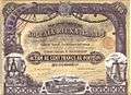 Joltaia Reka Iron Mining Company share, 1899
 Poshtovaya Street about 1900
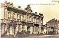 Krivoy Rog Mutual Credit Society
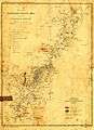 Region map in 1914
The export of ore in Silesia soon began. 5 schools[17] and an aerial cableway were created in the town, and the development of the city attracted new people looking for a quick profit.[18] The supply of mined ore far exceeded the demand, and so many mines completely suspended their work, while others had to reduce their workers and output by more than half. Workers did not have proper conditions, social security, or contracts, and they were prone to combinations of lung cancer, tuberculosis and asthma. Thousands of people who worked in the mines and the factories were left without employment. At the same time, the city began to develop the ideas of socialism and democracy. However, there were also several terrorist attacks and strikes, and 1905 brought anti-Jewish pogroms and repressions.[19]
The First World War interrupted access to the export markets, and a lot of workers were called to the front. The city survived Soldier and Worker's Deputies in 1917. Soviet Power was established in January 1918.[20][21] The Donetsk–Krivoy Rog Soviet Republic,[22] founded on 12 February 1918, became a self-declared republic of the Russian SFSR and sought independence from Ukraine. On 29 March 1918 it became a republic within Ukraine until it was fully occupied by German forces in support of the Central Rada. It was disbanded on 20 March 1918[23] when the independence of Soviet Ukraine was announced.[24]
Around this time, Kryvyi Rih's status was changed from township to city. It was founded by Uyezd as part of the Yekaterinoslav Governorate. It included 30 volosts. In late 1919, it was briefly ruled by the Volunteer Army.[20]
Soviet era
On January 17, 1920 the Red Army finally took Kryvyi Rih. City's population totaled 22,571. The city did not have a drinking water system until 1924, when a 55.3 km (34.4 mi) system was laid underground. Foreign investments were stopped, mines renewed. The first Mining Institute began work in 1929, and the Medical and Pedagogical Institutes were founded.[25] In 1931 the foundation of metallurgical works was laid ,[26] the first blast furnace of the metallurgical works gave metal 3 years later. The city grew rapidly. There are 160 industrial enterprises and 947 shops.[27]
Nazi occupation
During World War II, Kryvyi Rih was occupied by the German Army as part of the Reichskommissariat Ukraine from August 15, 1941 to February 22, 1944. Being evacuated from 20 September 1941 to August 1944, the Government, factories and Kryvyi Rih Institute worked in Nizhny Tagil. Germans immediately began to build up local government, installing executives, gendarmerie and police forces. Ukrainian national liberation movement in Krivoy Rog was organized by marching groups OUN. The answer came in the ethnic cleansing of Ukrainians as well as large-scale holocaust. On October 13, 1941 700 people were executed,[28] from October 1941 to April 1942 – 6293 persons, in August 1943 – 13 people.[27]
Hitler has repeatedly stressed the crucial importance of this area "As Nikopol manganese, its importance to us all can not be expressed in words. Loss of Nikopol (on the Dnieper, the south-west of Zaporozhye) would mean the end of war.[29] " In addition, the bridgehead on the left bank of the Dnieper left the German command a strike in order to restore the land connection with the group of forces locked in the Crimea.[30] During the first half of January,[31] Soviet troops made repeated attempts to eliminate the Nikopol-Krivoy Rog enemy group, but because of the stubborn resistance of German troops did not achieve success. Kryvyi Rih was almost totally destroyed by the fleeing German Army during Nikopol–Krivoy Rog Offensive.
 AEG power station built in 1930
 Wehrmacht soldiers operating 10.5 cm leFH 18. Svobody st., 1942
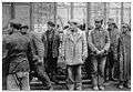 Soldiers arresting people, 1942
 Miners and pioneers pose in front of the Banner of Krivoi Rog. 1952.
 Dimitrova Street like many streets in the city centre is lined with dozens of stalinist buildings
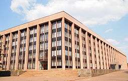 City Hall was built in the year of the city's 200th jubilee.
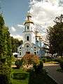 Nativity of the Theotokos Church, 1886, restored in the 2000s[32]
Post-Second World War and Post-Soviet
After the war, people lived among the ruins while housing stocks were rebuilt. The housing shortage was met by innovative technological solutions, which meant temporary barracks and houses could be built quickly. The two kinds of cheap new materials were used later for years afterwards.

Regeneration began in the late 1940s with initiatives such as Stakhanovite movement,[33] Khrushchyovkas, new mines, shoe and wool spinning-factory, Central Iron Ore Enrichment Works, Northern Iron Ore Enrichment Works, City Circus. Trolleybuses in Kryvyi Rih were launched in 1985,[34] Kryvyi Rih Airport became International. In 1990 Kryvbas produced 42% of USSR and 80% of Ukrainian ore extraction volume .[35]
Large sections of the city dating from the 1960s have been either demolished and re-developed or modernised with the use of beton and steel.[36] Old flats have been converted into modern apartments, 9 microdistricts of 17 and 9-floor panelák apartments have since been developed. Kryvyi Rih TV Mast is a 185m tall guyed tubular steel mast built in 1960, which carries in 2 levels 3 crossbars, which run from the mast structure to the guys. All three crossbars are equipped with gangways that carry additional smaller antennas.[37]
The city itself is laid out with broad avenues lined by wide sidewalks. Tram lines run down the centre of the major streets. Beside the sidewalks there are usually several rows of trees such as lindens and horse chestnuts. Many people live in rows of 5 to 9 story apartment buildings that are wrapped around large inner courtyards. Many of these courtyards are also filled with trees giving the overall impression that the entire city is built in a park.
The proclamation of the independence of Ukraine in 1991 brought about radical changes in every sphere of city life .[38] In the 1990s the city was known for its banditry,[39] which was successfully destroyed. Spurred by the investment after the 2005 Kryvorizhstal privatization by ArcelorMittal, and aided by Metinvest ,[40] Kryvyi Rih's city centre has undergone extensive regeneration.[41] City has of the biggest flower clocks in Europe.[42] New and renovated complexes such as Auchan and The Union have become popular shopping and entertainment destinations. Kryvyi Rih is among 30[43] most comfortable cities for living in Ukraine.
Government
|
 |
The City of Kryvyi Rih is governed by the Kryvyi Rih City Council. it is a city municipality that is designated as a separate district within its oblast.
Administratively, the city is divided into "raions" ("districts"). Presently, there are 7 raions: Dzerzhinskiy, Central City, Terny, Saksahan, Ingulets, Zhovtnevy and Dovhuntsevsky. Small townships, Avanhard, Horniatske, Ternovaty Kut, Kolomoitsevo and Nowoivanovka were added to the City.[44]
Originally Ingulets povit of Novorossiysk Governorate was established on lands of Ingulets palanca in 1775 after the destruction of the Zaporozhian Sich. In 1775/1776 it was part of Kherson Governorate. In 1783, the povit centre became Kryvyi Rih, and it was renamed to Kryvyi Rih povit. In 1860 Kryvyi Rih got the status of township in Kherson Governorate. In 1919 township was granted city status in Yekaterinoslav Governorate and, later, Dnipropetrovsk Oblast. As a result of the administrative reform in 1923 Kryvyi Rih povit converted to Kryvyi Rih okruga, which in 1930 became an independent administrative unit of Ukraine.[45][46]

Kryvyi Rih has three single-mandate parliamentary constituencies entirely within the city, through which members of parliament (MPs) are elected to represent the city in Rada. At the last general election, were won by PPB and independent candidates with representation being from Yuri Pavlov, Andriy Halchenko, Konstantin Usov respectively.[47] In multimember districts city voted for Opposition Bloc, union of all political forces that did not endorse Euromaidan.
In the last decades, Kryvyi Rih has generally supported candidates belonging to the Party of Regions and (in the 1990s) Communist Party of Ukraine in national and local elections. Same situation was with presidential elections, strong support had Leonid Kuchma and Viktor Yanukovych. After 2014 events of Euromaidan, mass demonstrations and clashes in central city,[48] Regions lost its influence, and Kryvyi Rih supported Petro Poroshenko.
Culture

Kryvyi Rih has a thriving theatre, circus and dance scene, and is home to a number of large performance venues. First theater was Coliseum in 1908, also the New Theatre of Vyzenberh and Hrushevskyy (1911, corner of Lenina and Kalynychenko st.). Kryvbas Theatre began its activities in, 1931, three years later incorporated with Shevchenko Theater. Another ones are Doll Theatre and Movement Theatre. Kryvyi Rih is famous as the birthplace Eugenie Gershoy, an American sculptor and watercolorist who emigrated with her family in 1903. Gershoy's work is in the collections of the Whitney Museum of American Art, the Metropolitan Museum of Art, and the Smithsonian American Art Museum. Her papers are held at Syracuse University.[50] Folk musician Eduard Drach, actress Helena Makowska and dancer Vladimir Malakhov also originated in the city.
The first screenings were conducted in the early 1920s. In 1934 Lenin Cinema was built, there are three of them – Olympus, Odessa and Multiplex[51] now open. Kryvyi Rih Circus feature large-scale exhibition space where fairs are held.[52] Soviet heritage are Palaces of Culture in every district of the city.
Local historical museum celebrate Cossaks history, rich industrial heritage and its role in the Soviet State. The municipally owned Art Gallery houses a collection of local painting.[53]
The night-time economy of city has expanded significantly since the 2000s. Big clubs such as Hollywood[54] and Sky, many tours of famous djs, pop and rap performers were based there. Another major scene of the city - Palace of Youth and Students of the KNU University.[55] The most popular fast-food, McDonalds, located at 95th Block. Ukrainian cuisine adjacent to bagels, cheesecake, hot dogs, shawarma and pizza, while Japanese cuisine and other Asian restaurants, hookahs, sandwich joints, trattorias and coffeehouses have become ubiquitous. Other well-known places – City Pub and Prado Cafe. The city is home to the annual electronic music Turbofly festival.[56] Rock band music, a tradition in the Ukraine, is an important part city's life and hosted in few small pubs.
Landmarks
Kryvyi Rih's buildings display a variety of architectural styles, ranging from eclecticism to contemporary architecture. The widespread use of red brick and block apartments character the city. Much of the architecture in the city harks back to its days as a centre for the ore trade. Just outside the immediate city centre is a large number of former factories, some of which have totally destroyed and in despare need of restavration.
Stalinist architecture is wide with neoclassical mass lowcoast apartments. City Hall is the best example of The decree On liquidation of excesses.[57] Khrushchyovka is a type of low-cost, concrete-paneled or brick three- to five-storied apartment building which was developed in the USSR during the early 1960s, during the time its namesake Nikita Khrushchev directed the Soviet government, dozens of such units are now past their design lifetime all over the city. There are 6 microdistricts.
The city has many Christian churches, the most notable being the Savior Transfiguration Cathedral. It is the main centre of Kryvyi Rih Eparchy founded on July 27, 1996.[58] Roman Catholic chapel located in old town. Pokrova church, Mykhailivska church and Christmas church were destroyed in the 1930s during the Great Purge, never to be used as a church again.[59]
In Kryvyi Rih judaism served by synagogue, reopened after World War II only in 2010.[60][61]
Large parks hold many of Kryvyi Rih's public monuments. City has mostly socialist realism style monuments to Cossaks, Olexander Paul, Taras Shevchenko (2), Bohdan Khmelnytsky (3, since 1954), Vasili Marguelov, Alexander Pushkin, Fyodor Sergeyev, Mikhail Lermontov and Maxim Gorky. Few Lenin monuments were destroyed during euromaidan events in 2014.[62] There are dozenz of cenotaphs and memorials to Second World War soldiers. A Sukhoi Su-15 is on display near Aviator Club, Yakovlev Yak-40 at National Aviation University, Vyzvolennia Square hold IS3 tank. Russian locomotive class Ye placed near Railway station.
 Kryvyi Rih Botanical Gardens of NAS
 Shevchenko Theatre
 Central Art Square
 Pushkin park in snow
Kryvyi Rih has few[63] designated natural monuments the old pear near Karnavatka, another pear of 1789,[64] Vizyrka landscape reserve, Northern and Southern Red Beam, Amphibolite, Arkose and Skelevatski Outputs, Mopr Rocks, Slate rocks, Sandstone rock.[65] Park named after the newspaper Pravda is very famous by its ampir boat station.[66] Kryvyi Rih Botanical Gardens of NAS est. in 1980.[67]
Education

Major Kryvyi Rih National University was originally formed as college and Mining Institute in 1929. It gained university status in 1982. Kryvyi Rih Pedagogical Institute it was founded in 1930 as an Institute of Vocational Training, is the oldest pedagogical institution in Kryvyi Rih, reorganized in Pedagogical Institute. In 2011 Cabinet of Ukraine founded Kryvyi Rih National University by uniting Mining Institute, Pedagogical University, Economic Institute of Kyiv National Economic University and Department of the National Metallurgical Academy of Ukraine.
Another institutions are local Department of Dnepropetrovsk State University of Internal Affairs, campuses of Zaporizhzhya National University, National University Odesa Law Academy and Interregional Academy of Personnel Management, college of National Aviation University.
In 2014 Donetsk Tugan-Baranovsky National University of Economics and Trade was evacuated to Kryvyi Rih after a long War in Donbass. Its future is uncertain.[68]
According to Frances Cairncross (in April 2010) “There are too many small universities, the majority of which are ineffectively governed and mired in corruption. They are not able to withstand existing global challenges.”[69] According to Anders Åslund (in October 2012) the quality of doctoral education is bad, particularly in management training, economics, law and languages.[70] He also signaled that the greatest problem in the Ukrainian education system is corruption.[70]
There are 149 general secondary schools and 150 nursery schools and kindergartens in Kryvyi Rih.[71] Additionally, there are evening schools for adults, musical, art, sports and specialist technical schools.
Sport
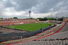
FC Hirnyk Kryvyi Rih is a football club based in Hirnyk Stadium, and currently competes in the Ukrainian First League. It is part of the Sports Club Hirnyk which combines several other sections. The club's owner is the Kryvyi Rih Iron Ore Combine (KZRK), the biggest subterranean mining public company in Ukraine.
Kryvyi Rih was also home to another football team, Kryvbas Kryvyi Rih. The team was founded as FC Kryvyi Rih in 1959. The next year it was part of the republican sport society Avanhard. After a couple of years it changed to Hirnyk, before obtaining current its name in 1966. Kryvbas debuted in the Ukrainian Premier League in the 1992–93 season. They had been in the top league since their debut, with their best finish in third place in the 1998–99 and 1999–2000 seasons. At the end of the 2012–13 season the team finished in 7th place, however, due to financial difficulties the club declared itself bankrupt in June 2013. FC Kryvbas-2 Kryvyi Rih was the reserve team of Kryvbas. In 1998 the club entered into the professional leagues to compete in the Second League. In 3 seasons the club moved to the Amateur Level before competing one last time in Second League.
SC Kryvbas is a professional basketball club. Achievements of the team are winning the Ukrainian Basketball League in 2009, and winning the Higher League in 2003 and 2004. Since 2010 the team is active in the Ukrainian Basketball SuperLeague.
The city is famous for its annual autorally. It was also the birthplace of the Ukrainian tennis players Valeria Bondarenko, Alona Bondarenko and Kateryna Bondarenko.
Geography


At 47°55′0″N 33°15′0″E / 47.91667°N 33.25000°E, 415 kilometres (260 mi) south of Kyiv, the city extends for 126 km from north to south,[72][73] paralleling the ore deposits. The city centre is on the east bank of the Inhulets River, near its confluences with the River Saksahan. Kryvyi Rih's geographic features were highly influential in its early development industrial city.
The city is set in the rolling steppe land surrounded by fields of sunflowers and grain. A short distance east of the city centre, there is an area along a small lake where glacial boulders were deposited. As a result, this area was never cultivated and contains one of the few remaining patches of wild steppe vegetation in the area. The city's environmental and construction safety is a growing problem due to abandoned mines and polluted ore-processing waste. According to the Scientific Hygienic Centre of Ukraine, the city is one of the most unfavourable places to live because of these problems.[74]
Climate
Kryvyi Rih experiences a dry continental climate (Dfb/Dfa) according to the Köppen climate classification system, like much of Ukraine. This tends to generate warm summers and cold winters with relatively low precipitation. Snowfalls are not common in the city, due to the urban warming effect. However,[75] districts that surround the city receive more snow and roads leading out of the city can be closed[76] due to snow.
| Climate data for Kryvyi Rih | |||||||||||||
|---|---|---|---|---|---|---|---|---|---|---|---|---|---|
| Month | Jan | Feb | Mar | Apr | May | Jun | Jul | Aug | Sep | Oct | Nov | Dec | Year |
| Record high °C (°F) | 13.0 (55.4) |
18.9 (66) |
23.5 (74.3) |
31.8 (89.2) |
35.8 (96.4) |
36.4 (97.5) |
38.6 (101.5) |
39.6 (103.3) |
36.4 (97.5) |
31.7 (89.1) |
21.7 (71.1) |
15.3 (59.5) |
39.6 (103.3) |
| Average high °C (°F) | −0.2 (31.6) |
0.6 (33.1) |
7.3 (45.1) |
15.6 (60.1) |
22.0 (71.6) |
25.2 (77.4) |
28.7 (83.7) |
28.9 (84) |
21.8 (71.2) |
13.9 (57) |
7.8 (46) |
0.7 (33.3) |
14.4 (57.9) |
| Daily mean °C (°F) | −3.5 (25.7) |
−3.1 (26.4) |
1.9 (35.4) |
9.6 (49.3) |
15.9 (60.6) |
19.5 (67.1) |
21.8 (71.2) |
21.2 (70.2) |
15.6 (60.1) |
9.1 (48.4) |
2.3 (36.1) |
−2.1 (28.2) |
9.0 (48.2) |
| Average low °C (°F) | −5.5 (22.1) |
−5.4 (22.3) |
−0.9 (30.4) |
4.3 (39.7) |
10.5 (50.9) |
14.1 (57.4) |
16.9 (62.4) |
16.3 (61.3) |
11.1 (52) |
5.2 (41.4) |
1.5 (34.7) |
−4.4 (24.1) |
5.3 (41.5) |
| Record low °C (°F) | −27.2 (−17) |
−27.3 (−17.1) |
−21.0 (−5.8) |
−8.9 (16) |
−1.6 (29.1) |
2.8 (37) |
7.3 (45.1) |
5.0 (41) |
−3.7 (25.3) |
−10.0 (14) |
−18.6 (−1.5) |
−24.5 (−12.1) |
−27.3 (−17.1) |
| Average precipitation mm (inches) | 30 (1.18) |
30 (1.18) |
24 (0.94) |
28 (1.1) |
45 (1.77) |
62 (2.44) |
59 (2.32) |
32 (1.26) |
38 (1.5) |
37 (1.46) |
31 (1.22) |
28 (1.1) |
444 (17.48) |
| Source: Pogoda.ru.net[77] | |||||||||||||
Demographics
| National communities | |
|---|---|
| Russian | |
| Armenian | |
| Moldovan | |
| Polish | |
| Jewish | |
| Romani | |
| Georgian | |
 |
Historically the population of Kryvyi Rih began to increase rapidly during the Interwar period, peaking at 197 000 in 1939.[78] From than the population began to decrease rapidly, due to foreign workers and increased building of social housing overspill estates by Kryvyi Rih City Council after the Second World War such as Sotshorod and Sonyachny.[79]
The 2014 Estimate for the population of Kryvyi Rih was 654,900 (8th in Ukraine). This was a decrease of 4 348 since the 2013 E. Since 2001, the population has grown by 48 001. In 2013, deaths exceeded births by 3589. Net migration rate is 234 (negative).[78][80]
According to the UNHCR and City Council, 7000 people of Donetsk and Luhansk have fled to Kryvyi Rih since the beginning of 2014 War in Donbass, not including those who did not register as asylum seekers.[81][82][83][84][85][86]
Kryvyi Rih has traditionally been Christian, and has a large number of churches, particularly in the central city. The well-known Savior Transfiguration Cathedral in Saksahan Raion is Orthodox administrative center, bishop of the Kryvyi Rih Eparchy has his main residence here. The town has a school of icon painting. Patron saint of the city is Saint Nicholas as well as bishops Onufry and Porphyry.[87] The majority of regions Jews live here, with significant Jewish community. Beis Shtern Shtulman Synagogue[88] in the Central City was open in 2010. In the early twentieth century, the city had two synagogues, located on the Kaunas street. As part of Roman Catholic Diocese of Kharkiv-Zaporizhia city has Kostel of Mary Mother of Jesus. Kryvyi Rih is also home to Evangeliums-Christen, CEF and Vedas communities.
LGBT people may experience different social attitudes and public policies.
In terms of ethnic composition, there is no official statistics but history showed that Jews, make up the single largest ethnic minority[89] of 15 000, followed by Russians and Armenians. Other large immigrant groups are people from Korea, Poland, Moldova, Azerbaijan and Roms.[90] The area also attracts large numbers of African students to the city who attending the local universities.[91] Central city and Dovhuntsevsky Raion are centres of population for ethnic minorities.
The Kryvyi Rih Metropolitan Region has a population of 900 000 in 2013. In addition to Kryvyi Rih itself, the KMR includes the 5 raions of the Dnipropetrovsk Oblast. The KMR is the sixth largest within the Ukraine.
Economy
In mid-2014 Kryvyi Rih had a IPI of ₴41.6bn[71][92] (about $3bn[93]) with 17.9% growth which is 41.8% of Dnipropetrovsk Oblast IPI. Export reached $2.520m (4.9% decreese), Import - $276m. City got $4.899m of foreign Investmentments, mainly from Germany, Cyprus, Netherlands, and the UK.
Official unemployment throughout 2014 averaged 0.63%. Average wage is ₴4.022 ($266,[93] 19.4% more than average Ukraine).[71][92]
Processing and mining industry - the two largest sectors of Kryvyi Rih. Rest fraction is about 50%. City has over 53[94] plants, mines and factories. ArcelorMittal Kryvyi Rih, owned by ArcelorMittal since 2005 is the largest private company by revenue in Ukraine,[95] producing over 7 million tonnes of crude steel, and mined over 17 million tonnes of iron or. As of 2011, the company employed about 37 000 people. 4 Iron Ore Enrichment Works of Metinvest are a large contributors to the UA's balance of payments. Another giants of city are Evraz mining company and HeidelbergCement.[71][92]
Transport
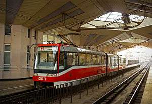
Local public transportation in Kryvyi Rih includes the Metrotram (underground), buses[71][92] and minibuses line, trolleybuses (in operation since 1957, the system presently comprises 23 routes), trams (one of world's largest tram networks, operating on 105.8 kilometres of total route. As of 2014, it was composed of 13 lines) and, taxi.
The publicly owned and operated Kryvyi Rih Metrotram is the fastest, the most convenient and affordable network that covers most, but not all, of the city. The Metrotram is continuously expanding towards the city limits to meet growing demand, currently having three lines with a total length of 18.7 kilometres (11.6 miles) and 16 stations. Despite its designation as a "metro tram" and its use of tram cars as rolling stock, the Kryvyi Rih Metrotram is a complete rapid transit system with enclosed stations and tracks separated both from roads and from the city's conventional tram lines. City public transport provided servises for 66m persons in first part of 2014.[71][92]
 Prospekt Metalurhiv station of the Kryvyi Rih Metrotram was Opened in 1989
 Commuter rail train at the Kryvyi Rih Main Station. The city's railroads have a long history.
The Kryvyi Rih public transport system, except for taxi, uses a simple flat rate tariff system regardless of distance traveled: tickets or tokens must be purchased each time a vehicle is boarded. Discount passes are available for grade school and higher education students. Pensioners use public transportation free. Ticket prices are regulated by the city government, and the cost of one ride is far lower than in Western Europe.
The historic tram system,[34] once a well maintained and widely used method of transport, is now gradually being phased out in favor of buses and trolleybuses.
The city has no cycling lines. The taxi market is expansive but not regulated. In particular, the taxi fare per kilometer is not regulated. There is a fierce competition between private taxi companies.
Kryvyi Rih International Airport is the airport that serves the city. It is located 17.5 km (10.9 Miles) northwest of the city of Kryvyi Rih.
Twin cities
Kryvyi Rih has two historic sister cities:[96][97]
 Handan
 Nizhny Tagil (1942, 1994)
See also
- List of people from Kryvyi Rih
References
Footnotes
- ↑ (Ukrainian) VILKUL oath mayor of Kryviy Rih, Ukrayinska Pravda (31 March 2016)
- ↑ "Kryvyi Rih (Ternopil Oblast, Kryvyi Rih Raion)". weather.in.ua. Retrieved 27 February 2012.
- ↑ Oxford Dictionaries. "Kryvyi Rih". Oxford University Press, 2013. Accessed 27 August 2013.
- ↑ "UA population estimates". Office for National Statistics.
- ↑ Богатые и бедные регионы Украины: таблица. Vedomosti
- ↑ "Комаров В.О. Iсторiя Криворiжжя Днепропетровск: Сiч, 1992". kryvyirih.dp.ua.
- ↑ "Історична хроніка подій 1734-1900. Олександр О.Мельник, ведучий науковий співробітник Криворізького історико-краєзнавчого музею". kryvyirih.dp.ua.
- ↑ В. Ізмайлов. Подорож у полуденну Росію в 1799 р. у листах, виданих Володимиром Ізмайловим
- ↑ Перелік (Списку) казенних селищ Херсонського й Олександрійського повітів, які у 1816 - 1817 р.р. були звернені у військові поселення
- ↑ «По Катерининській залізниці», вип. 1-й, Katerinoslaw, 1903 р
- ↑ Brockhaus and Efron Encyclopedic Dictionary 1890—1907
- ↑ Sudrussland Mageteisen und Sisenglantztatten
- ↑ Рубін П.Криворожский бассейн и его железные руды. Горный журнал, 1888 г., т. 1
- ↑ Конткевич С. Геологічний опис околиць Кривого Рогу, Херсонської губернії
- ↑ Записки капитан-лейтенанта Семечкина», Вид. Об-ва горных инженеров, 1900 р
- ↑ "Початок добутку залізної руди. Індустріальний розвиток (1881 – 1899)". kryvyirih.dp.ua.
- ↑ Діловий і комерційний Кривий Ріг. 1914 р
- ↑ Гірничо-заводський листок №4,1902р
- ↑ "Історична хроніка подій (м. Кривий Ріг) 1900-1903". kryvyirih.dp.ua.
- 1 2 "Історична хроніка подій (м. Кривий Ріг) 1900-1903". kryvyirih.dp.ua.
- ↑ Снегирёв В. В. Между двух огней. Предыстория создания ДКР // «Молодогвардеец» — Луганск, 6−11.10.1990.
- ↑ Материалы о Донецко-Криворожской Республике. Сост. и предисл. Х. Мышкис // «Літопис Революції»: Журнал Істпарту ЦК КП(б)У — 1928. — № 3(30).
- ↑ Гамрецький Ю. М. ІІ обласний з"їзд Рад Робітничих і Солдатських Депутатів Донбасу і Криворіжжя // Питання історії СРСР, № 22. — Харків, 1977.
- ↑ Лихолат А. В. Здійснення ленінської національної політики на Україні — Київ, 1967. — С.156−161.
- ↑ "Історія КНУ". knu.edu.ua.
- ↑ "Our History. ArcelorMittal.". arcelormittal.com.ua.
- 1 2 "Історична хроніка подій 1917 - 2002". kryvyirih.dp.ua.
- ↑ "Marmer jewish Museum". jewish-museum-marmer.dp.ua.
- ↑ История Второй мировой войны. 1939—1945. / Коллектив авторов. — Т. 8. — М.: Воениздат, 1977.
- ↑ Типпельскирх К. История Второй мировой войны. — СПб.: Полигон; М.:АСТ, 1999.
- ↑ Грылев А. Н. Днепр — Карпаты — Крым. — М.: Наука, 1970.
- ↑ Божко А. А. Храм Рождества Пресвятой Богородицы (1886—2012): Исторический очерк / Алексей Алексеевич Божко. — Кривой Рог, 2012. — 84 с., ил.
- ↑ Українська радянська енциклопедія. В 12-ти томах / За ред. М. Бажана. — 2-ге вид. — К.: Гол. редакція УРЕ, 1974-1985.
- 1 2 Електротранспорт України: Енциклопедичний путівник / Сергій Тархов, Кость Козлов, Ааре Оландер. — Київ: Сидоренко В. Б., 2010. — 912 с.: іл., схеми. — ISBN 978-966-2321-11-1.
- ↑ "Our History. ArcelorMittal.". arcelormittal.com.ua.
- ↑ Осуществленные строительством основные объекты архитектора Иосифа Каракиса // Архитектор Иосиф Каракис: Судьба и творчество (Альбом-каталог к столетию со дня рождения) / Под ред. Бабушкин С. В., Бражник Д., Каракис И. И., А. Пучков; Сост. Д. Бражник, И. Каракис, И. Несмиянова. — Киев, 2002. — С. 97. — 102 с. — (Н0(4УКР)6-8). — ISBN 966-95095-8-0.
- ↑ "Криворожская телевышка.". 1kr ua.
- ↑ "Our History. ArcelorMittal.". arcelormittal.com.ua.
- ↑ ""Бегуны". История глупой войны.". kri.com.ua.
- ↑ "Реконструкция.". KRLife.
- ↑ "Проспект Маркса.". KRLife.
- ↑ "Криворожские цветочные часы попали в Книгу рекордов.". Rambler News.
- ↑ "Фокус определил 50 лучших городов для жизни в Украине". focus.ua.
- ↑ "Виконком міської ради.". kryvyirih.dp.ua.
- ↑ Волости и важнѣйшія селенія Европейской Россіи. По данным обслѣдованія, произведеннаго статистическими учрежденіями Министерства Внутренних Дѣл, по порученію Статистическаго Совѣта. Изданіе Центральнаго Статистическаго Комитета. Выпуск VIII. Губерніи Новороссійской группы. СанктПетербургъ. 1886. — VI + 157 с.
- ↑ Всесоюзная перепись населения 1926 года. М.: Издание ЦСУ Союза ССР, 1928-29. Том 10-16. Таблица VI. Население по полу, народности
- ↑ "СПИСОК народних депутатів України, обраних на позачергових виборах народних депутатів України 26 жовтня 2014 року". «Голос України». — № 218 (5968). — 2014. — 12 листопада. — С. 4–9.
- ↑ "Криворожский Евромайдан". 0664.
- ↑ World's biggest floral clock begins to tick off time in Ukraine's Kryvyi Rih (Ukrinform)
- ↑ http://library.syr.edu/digital/guides/g/gershoy_e.htm
- ↑ "Киноафиша". Киноафиша.
- ↑ "Kryvyi Rih Circus". Kryvyi Rih Circus.
- ↑ "Local Museum". 1KR UA.
- ↑ "Hollywood city VK". Hollywood city VK.
- ↑ "KNU students Club". KNU.
- ↑ "Turbofly VK". Turbofly VK.
- ↑ Architecture of The Stalin Era, by Alexei Tarkhanov (Collaborator), Sergei Kavtaradze (Collaborator), Mikhail Anikst (Designer), 1992, ISBN 978-0-8478-1473-2
- ↑ Aboute Kryvyi Rih Eparchy
- ↑ 1775 DP UA
- ↑ Hystory of Kryvyi Rih. Marmer Museum Foundation
- ↑ В Кривом Роге открыли одну из крупнейших синагог в Восточной Европе - TSN
- ↑ Vandals continue demolition of monuments to Vladimir Lenin in Ukraine (TASS)
- ↑ Загальні відомості про природно-заповідний фонд (ПЗФ) Криворіжжя, Kryvyi Rih Pedagogical Institute
- ↑ Енциклопедія Криворіжжя. — У 2-х т./Упоряд. В. П. Бухтіяров. — Кр. Ріг: «ЯВВА», 2005
- ↑ Dnipropetrovsk State Library
- ↑ Парк им. газеты "Правда", Foursquare
- ↑ Kryvyi Rih Botanic garden
- ↑ "Из Донецкой и Луганской областей эвакуированы уже девять университетов". ZN UA.
- ↑ Education problems deeper than language, Kyiv Post (2 April 2010)
- 1 2 Outdated educational system translates into lagging economy, Kyiv Post (4 October 2012)
- 1 2 3 4 5 6 "Бюлетень "Кривий Ріг у цифрах і фактах 2013 р." (PDF). Kryvyi Rih City Council. 2013.
- ↑ Dnepropetrovsk Oblast 1:200,000 map, Ukraine 2004 and 2005.
- ↑ The following website claims that: "Currently, the city of Krivoy Rog has an area of 430.0 km2, and extends 126 km (78.29 mi) from north to south (the largest in Europe) and is 20 km (12.43 mi) in width." ("В настоящий момент город Кривой Рог занимает территорию площадью 430,0 км2 и имеет протяжность с севера на юг 126 км (наибольшая в Европе) и ширину до 20 км.:) Официальный сайт исполсома города Кривщгщ Рого (ru) (ua).
- ↑ Библиотечный каталог авторефератов Украины, Scientific Hygienic Centre of Ukraine.
- ↑ http://www.0564.ua/news/110563
- ↑ http://nbnews.com.ua/ru/news/111848/
- ↑ "Климат Кривого Рога (Climate of Kryvyi Rih" (in Russian). Pogoda.ru.net. 2016. Retrieved 7 August 2016.
- 1 2 "Демографічний прогноз міста Кривого Рогу. Кривий Ріг" (PDF). Kryvyi Rih City Council. 2013.
- ↑ "Історична хроніка подій (м. Кривий Ріг)". kryvyirih.dp.ua.
- ↑ "Демоситуацiя". Kryvyi Rih City Council.
- ↑ "More Than a Million Ukrainians Have Been Displaced, U.N. Says". The New York Times. 2 September 2014.
- ↑ "ООН: Домівки через бойові дії в Україні полишили понад 415 тисяч людей". Deutsche Welle. August 20, 2014.
- ↑ "UNHCR: 730,000 flee Ukraine for Russia". Deutsche Welle. August 20, 2014.
- ↑ "В Кривой Рог опять массово кинулись беженцы с востока". krlife.com.ua.
- ↑ "На Дніпропетровщині будуть створені бізнес-центри для переселенців". krlife.com.ua.
- ↑ "Сколько переселенцев с восточных областей в Кривом Роге?". comments.ua.
- ↑ "Мост Днепр".
- ↑ http://www.krjew.com/
- ↑ "Міські осередки громадських організацій та об'єднань". kryvyirih.dp.ua.
- ↑ http://cityblog.com.ua/2013/09/festival-natsionalno-kulturnyih-soobshhestv-v-krivom-roge/
- ↑ "KNU International". KNU.
- 1 2 3 4 5 "Економічний прогноз. Кривий Ріг" (PDF). Kryvyi Rih City Council. 2013.
- 1 2 http://www.xe.com/currencycharts/?from=UAH&to=USD
- ↑ http://info.1kr.ua/category-423-482.html?private_property=-1&p=5
- ↑ Top Ukrainian Companies By Revenue
- ↑ "Города-побратимы. Нижний Тагил". Администрация Нижнего Тагила.
- ↑ "Перелік державних та муніципальних сайтів". Kryvyi Rih City.
Bibliography
- Криворожье. Справочник-путеводитель / Днепропетровск: Днепропетровское книжное издательство, 1963. — 162 с. (in Russian)
- Кривому Рогу — 200. Историко-экономический очерк / Редколлегия: П. Л. Варгатюк и др. — Днепропетровск: «Промінь», 1975. — 208 с. (in Russian)
- Новик Л. И. Кривой Рог: Путеводитель-справочник / Л. И. Новик, Д. И. Кан. — Днепропетровск: «Промiнь», 1986. — 191 с., цв. ил. (in Russian)
- Пахомов А. Г., Борьба трудящихся Криворожья за власть Советов / А. Г. Пахомов. — Днепропетровск: Днепропетровское областное издательство, 1958. — 204 с. (in Russian)
- Альбом Кривой Рог-Гданцевка. 1899. (in German)
- Кривой Рог: Фотоальбом. — Киев: «Мистецтво», 1971. — 137 с., цв. ил. (in Ukrainian)
- Кривий Ріг: Фотоальбом. — Киев: «Мистецтво», 1976. — 146 с., цв. ил. (in Ukrainian)
- Кривий Ріг: Фотоальбом. — Киев: «Мистецтво», 1983. — 143 с., цв. ил. (in Ukrainian)
- Кривий Ріг: Фотоальбом. — Киев: «Мистецтво», 1989. — 144 с., цв. ил. (in Ukrainian)
- Кривий Ріг — моє місто / Тамара Трофанова. — Кривий Ріг: Видавничий дім, 2009. — [36] с.: фотогр. — 3500 (1 завод-1000) экз. — ISBN 978-966-177-038-5. (in Ukrainian)
- Кривий Ріг: фотоальбом / редкол.: Г. П. Гончарук (ред.) и др.; фотогр. А. Соловьёв. — Д.: АРТ-ПРЕСС, 2010. — 152 с.: фотогр. — на укр. и англ. языках. — 2200 экз. — ISBN 978-966-348-227-9. Посвящён 235-летию Кривого Рога. (in Ukrainian)
- Рукавицын И. А. Привет из Кривого Рога / И. А. Рукавицын. — К.: Арт-Технология, 2014. — 104 с.: ил. (русский язык)
- Визначні місця України / Київ: Держполітвидав УРСР, 1961. — 787 с. (in Ukrainian)
- Криворожский горнорудный институт. К 50-летию института / Коллектив авторов. — Издательство Львовского университета, 1972. — 184 с. (in Russian)
- Грушевой К. С. Тогда, в сорок первом… / К. С. Грушевой. — Москва, 1972. — 78 с. (in Russian)
- Мельник О. О., Криворіжжя: від визволення до перемоги. Хроніка подій з 22 лютого 1944 до 9 травня 1945 р / О. О. Мельник. — Кривий Ріг: Видавничий дім, 2004. — 56 с. (in Ukrainian)
- Советская историческая энциклопедия / Москва: «Советская энциклопедия», 1965. — Том 8, С. 150—151. (in Russian)
- Украинская советская энциклопедия. Том 5 (in Ukrainian), — С. 499—500. (in Russian)
- История Городов и Сёл Украинской ССР (в 26 томах). Том Днепропетровская область, — С. 285—323. (in Russian)
- Фокин Е. И. Хроника рядового разведчика. Фронтовая разведка в годы Великой Отечественной войны. 1943—1945 гг. / Е. И. Фокин. — М.: ЗАО «Центрполиграф», 2006. — 285 с. — (На линии фронта. Правда о войне). Тираж 6 000 экз. ISBN 5-9524-2338-8. (in Russian)
- Географический энциклопедический словарь. Географические названия. Издание второе, дополненное / Гл. ред. А. Ф. Трёшников. — Москва: «Советская энциклопедия», 1989. (in Russian)
External links
- Kryvyi Rih administration website (Ukrainian) (English) (Russian)
- Kryvyi Rih at DMOZ
- 1kr City News (Russian)
- Google Maps Satellite Image of Kryvyi Rih
- Testing the mettle of Ukraine's steel city from the BBC World News (English)
- The murder of the Jews of Kryvyi Rih during World War II, at Yad Vashem website.
 |
|
|
|
|
| |
|
| ||
| ||||
| | ||||
| |
|
|
| Raions |
| |
|---|---|---|
| Urban-type settlements |
| |
| Villages |
| |
| Raions | |||||||
|---|---|---|---|---|---|---|---|
| Cities |
| ||||||
| |||||||