Inhulets River
| Inhulets, Інгулець | |
|---|---|
 | |
| Country | Ukraine |
| Basin | |
| Main source | Kirovohrad Oblast, Ukraine |
| River mouth | Dnieper River |
| Basin size | 14,870 km2 (5,740 sq mi) |
| Physical characteristics | |
| Length | 549 km (341 mi) |
The Inhulets (Ukrainian: Інгулець) or Ingulets (Russian: Ингуле́ц) is a river, a right tributary of the Dnieper River, which flows through Ukraine. It has a length of 549 km and a drainage basin of 14,870 km².
The Inhulets has its source in the Dnieper highlands near the city of Kropyvnytskyi in the Ukrainian province of Kirovohrad, about 30 km away from the Dnieper river itself, with which it flows parallel to. The Inhulets then turns south, where it flows through the Dnipropetrovsk, Kherson, and Mykolaiv Oblasts, before finally flowing approx. 30 km east of the city of Kherson into the Dnieper.
While flowing near the city of Kryvyi Rih, the course of the river has created many small islands, which have a rich vegetation. However, the vegetation is impaired by the high level of contamination of the river, due to the nearby mining industry.
Important tributaries of the Inhulets river are the Saksahan River and the Vysun River. Cities and town located on the river include Kryvyi Rih, Inhulets, and Snihurivka.
| Tributaries1 | 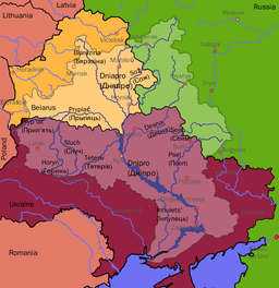 | |
|---|---|---|
| Reservoirs |
| |
| Hydroelectric stations | ||
| Canals |
| |
| Cities | ||
1 Italics indicate left tributaries | ||
Coordinates: 46°41′03″N 32°48′45″E / 46.6842°N 32.8125°E