Kostelní Hlavno
| Kostelní Hlavno | |||
|---|---|---|---|
| Municipality and village | |||
|
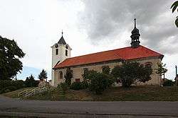
Church in Kostelní Hlavno | |||
| |||
 | |||
| Country |
| ||
| Region | Central Bohemian Region | ||
| District | Prague-East District | ||
| Area | |||
| • Total | 2.64 sq mi (6.83 km2) | ||
| Elevation | 636 ft (194 m) | ||
| Population (2011) | |||
| • Total | 504 | ||
| • Density | 190/sq mi (74/km2) | ||
| Time zone | CET (UTC+1) | ||
| • Summer (DST) | CEST (UTC+2) | ||


Kostelní Hlavno (german: Kirchenhlawno; (or older) Glauen)[1] is a village and municipality in Prague-East District in the Central Bohemian Region of the Czech Republic.
References
- ↑ Antonín Profous: Místní jména v Čechách : Jejich vznik, původ, význam a změny. Bd. I.-III., Česká akademie věd a umění, Praha
- This article was initially translated from the Czech Wikipedia.
| Wikimedia Commons has media related to Kostelní Hlavno. |
Coordinates: 50°15′N 14°42′E / 50.250°N 14.700°E
This article is issued from Wikipedia - version of the 9/8/2016. The text is available under the Creative Commons Attribution/Share Alike but additional terms may apply for the media files.