Stogumber

Coordinates: 51°07′47″N 3°17′41″W / 51.1296°N 3.2947°W
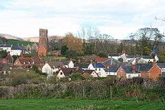
Stogumber is a village and civil parish in Somerset, England, on the eastern flank of the Brendon Hills. Besides Stogumber village itself, the parish includes the hamlets of Ashbeer, Capton, Escott, Higher Vexford, Kingswood, Lower Vellow, Lower Vexford, Preston, and Vellow. The village is on the route of the Samaritans Way South West.
History
The name comes from the Old English Stoke meaning place or dairy farm with the addition in 1225 of the personal name Gunner.[2]
Approximately 0.8 miles (1.3 km) north-west of the village is Curdon Camp a univallate Iron Age hill fort.[3] The camp was nearly completely destroyed by quarrying and bulldozing.
The parish of Stogumber was part of the Williton and Freemanners Hundred.[4]
The manor of Stogumber was held from 1286 by the Andleys family and later the Sydenhams (1396–1626) and Notleys (from 1896).[2]
Five fulling mills were established in the village between the 13th and 18th century to support the cloth making industry.[2]
A 19th-century limekiln in Lower Vellow was originally attached to a quarry.[5]
Governance
The parish council has responsibility for local issues, including setting an annual precept (local rate) to cover the council's operating costs and producing annual accounts for public scrutiny. The parish council evaluates local planning applications and works with the local police, district council officers, and neighbourhood watch groups on matters of crime, security, and traffic. The parish council's role also includes initiating projects for the maintenance and repair of parish facilities, as well as consulting with the district council on the maintenance, repair, and improvement of highways, drainage, footpaths, public transport, and street cleaning. Conservation matters (including trees and listed buildings) and environmental issues are also the responsibility of the council.
The village falls within the Non-metropolitan district of West Somerset, which was formed on 1 April 1974 under the Local Government Act 1972, having previously been part of Williton Rural District.[6] The district council is responsible for local planning and building control, local roads, council housing, environmental health, markets and fairs, refuse collection and recycling, cemeteries and crematoria, leisure services, parks, and tourism.
Somerset County Council is responsible for running the largest and most expensive local services such as education, social services, libraries, main roads, public transport, policing and fire services, trading standards, waste disposal and strategic planning.
It is also part of the Bridgwater and West Somerset county constituency represented in the House of Commons of the Parliament of the United Kingdom. It elects one Member of Parliament (MP) by the first past the post system of election, and part of the South West England constituency of the European Parliament which elects seven MEPs using the d'Hondt method of party-list proportional representation.
Landmarks
Combe Sydenham is a Grade I listed 15th-century manor house.[7]
Hartrow Manor was a late-16th-century manor house.[8]
Transport
Stogumber railway station is an intermediate station on the West Somerset Railway, now a steam-operated heritage railway operating between Bishops Lydeard, near Taunton, and Minehead.
Religious sites
The parish Church of St Mary dates from the late 13th century. It has been designated as a Grade I listed building.[9] It was founded as a Saxon minster with a chapelry at Bicknoller and other dues payable from property in Monksilver, Clatworthy and Elworthy.[2] The Old Vicarage which is a now private dwelling, was built in the 15th century.[10] The old brewhouse behind the vicarage is medieval in origin.[11]
The Chantry chapel in Vellow was licensed as the Chapel of Our Lady Sweetwell in 1542.[12]
The Baptist Church in Brook Street dates from the 19th century.[13]
Notable residents
- George Fredrick Curtis (1906–2005), the founding dean of the University of British Columbia Faculty of Law was born in the village.
- Elizabeth Sydenham of Combe Sydenham married Sir Francis Drake in the village in 1583.[2]
- Richard Tucker Founder of (now) Portland, Maine in 1633 was born in Stogumber in 1594.[14]
In literature
John de Stogumber is the name of a bishop in George Bernard Shaw's play Saint Joan. The name was selected after Shaw contacted the local rector to check that there was no-one living with the surname.[15]
References
- ↑ "Statistics for Wards, LSOAs and Parishes — SUMMARY Profiles" (Excel). Somerset Intelligence. Retrieved 4 January 2014.
- 1 2 3 4 5 Bush, Robin (1994). Somerset: The Complete Guide. Dovecote Press. pp. 193–194. ISBN 1-874336-26-1.
- ↑ "Curdon Wood Camp". Somerset Historic Environment Record. Digital Digging. Retrieved 28 December 2010.
- ↑ "Somerset Hundreds". GENUKI. Retrieved 23 October 2011.
- ↑ "Lime Kiln at NGR ST 0969 3873". Images of England. English Heritage. Retrieved 2009-02-06.
- ↑ "Williton RD". A vision of Britain Through Time. University of Portsmouth. Retrieved 5 January 2014.
- ↑ "Combe Sydenham". Images of England. English Heritage. Retrieved 2009-02-06.
- ↑ "Hartrow Manor". Images of England. English Heritage. Retrieved 2009-02-06.
- ↑ "Church of St Mary". Images of England. English Heritage. Retrieved 2009-02-06.
- ↑ "The Old Vicarage". Images of England. English Heritage. Retrieved 2009-02-06.
- ↑ "The Brewhouse, about 10 metres South of The Old Vicarage". Images of England. English Heritage. Retrieved 2009-02-06.
- ↑ "Vellow Chantry". Images of England. English Heritage. Retrieved 2009-02-06.
- ↑ "Baptist Church". Images of England. English Heritage. Retrieved 2009-02-06.
- ↑ New England Historical Genealogical Register,: Volume 53 1899
- ↑ Byford, Enid (1987). Somerset Curiosities. Dovecote Press. p. 114. ISBN 0946159483.
External links
| Wikimedia Commons has media related to Stogumber. |
- The Somerset Urban Archaeological Survey: Stogumber, by Clare Gathercole
- Stogumber village website
