Brompton Regis
| Brompton Regis | |
 Brompton Regis |
|
 Brompton Regis |
|
| Population | 449 (2011)[1] |
|---|---|
| OS grid reference | SS955315 |
| District | West Somerset |
| Shire county | Somerset |
| Region | South West |
| Country | England |
| Sovereign state | United Kingdom |
| Post town | DULVERTON |
| Postcode district | TA22 |
| Dialling code | 01398 |
| Police | Avon and Somerset |
| Fire | Devon and Somerset |
| Ambulance | South Western |
| EU Parliament | South West England |
| UK Parliament | Bridgwater and West Somerset |
Coordinates: 51°04′24″N 3°29′35″W / 51.0733°N 3.4930°W
Brompton Regis (formerly known as Kingsbrompton) is a village and civil parish in the West Somerset district of Somerset, England about 5 miles (8.0 km) north-east of Dulverton. It is situated on the River Haddeo in the Brendon Hills within the Exmoor National Park, close to Wimbleball Lake, a water supply reservoir constructed in the 1970s and completed in 1979. According to the 2011 census the village had a population of 449.[1] The parish boundary is marked by the River Exe which is crossed by the medieval Chilly Bridge[2] and Hele Bridge.[3] The Haddeo is crossed by Bury Bridge.[4]
The parish includes the village of Withiel Florey, where the Church of St Mary Magdalene has 12th-century origins and has been designated as a Grade II* listed building,[5] and the hamlets of Bury, Gupworthy and Hartford.
History
Before the Norman Conquest the manor was held by Gytha Thorkelsdóttir and was seized by William the Conqueror. The parish of Withiel Florey was part of the Taunton Deane Hundred, while Brompton Regis was part of the Williton and Freemanners Hundred.[6] By the later 12th century Brompton Regis had been granted to William de Say, who founded Barlynch Priory in the west of the parish. In the 13th century it passed to the Besil family who had a Motte and Bailey castle near Bury, known as Bury Castle.[7]
Gupworthy was the terminus of the West Somerset Mineral Railway which ran from the ironstone mines in the Brendon Hills to the port of Watchet on the Bristol Channel.[8]
Bury Bridge over the River Haddeo is a medieval packhorse bridge. It has been scheduled as an ancient monument and Grade II* listed building.[9][10]
Governance
The parish council has responsibility for local issues, including setting an annual precept (local rate) to cover the council’s operating costs and producing annual accounts for public scrutiny. The parish council evaluates local planning applications and works with the local police, district council officers, and neighbourhood watch groups on matters of crime, security, and traffic. The parish council's role also includes initiating projects for the maintenance and repair of parish facilities, as well as consulting with the district council on the maintenance, repair, and improvement of highways, drainage, footpaths, public transport, and street cleaning. Conservation matters (including trees and listed buildings) and environmental issues are also the responsibility of the council.
The village falls within the Non-metropolitan district of West Somerset, which was formed on 1 April 1974 under the Local Government Act 1972, having previously been part of Dulverton Rural District.[11] The district council is responsible for local planning and building control, local roads, council housing, environmental health, markets and fairs, refuse collection and recycling, cemeteries and crematoria, leisure services, parks, and tourism.
There is an electoral ward called 'Brendon Hills'. This stretches from Brompton Regis eastwards to Brompton Ralph. The total population of this ward at the 2011 Census was 1,287.[12]
Somerset County Council is responsible for running the largest and most expensive local services such as education, social services, libraries, main roads, public transport, policing and fire services, trading standards, waste disposal and strategic planning.
As Brompton Regis falls within the Exmoor National Park some functions normally administered by district or county councils have, since 1997, fallen under the Exmoor National Park Authority, which is known as a ‘single purpose’ authority, which aims to "conserve and enhance the natural beauty, wildlife and cultural heritage of the National Parks" and "promote opportunities for the understanding and enjoyment of the special qualities of the Parks by the public",[13] including responsibility for the conservation of the historic environment.[14]
It is also part of the Bridgwater and West Somerset county constituency represented in the House of Commons of the Parliament of the United Kingdom. It elects one Member of Parliament (MP) by the first past the post system of election, and part of the South West England constituency of the European Parliament which elects seven MEPs using the d'Hondt method of party-list proportional representation.
Religious sites
The parish Church of St Mary in Brompton Regis has a 13th-century tower, with the rest of the church being from around 1490.[15]
See also
Gallery
 Brompton Regis: Redcross Farm
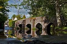 The Ancient bridge and ford at Bury 51°2′12.28″N 3°30′23.65″W / 51.0367444°N 3.5065694°W
 Hadborough trig point.
References
| Wikimedia Commons has media related to Brompton Regis. |
- 1 2 "Statistics for Wards, LSOAs and Parishes — SUMMARY Profiles" (Excel). Somerset Intelligence. Retrieved 4 January 2014.
- ↑ "Chilly Bridge". Images of England. English Heritage. Retrieved 29 November 2008.
- ↑ "Hele Bridge". Images of England. English Heritage. Retrieved 29 November 2008.
- ↑ "Bury Bridge". Images of England. English Heritage. Retrieved 29 November 2008.
- ↑ "Church of St Mary Magdalene". Images of England. English Heritage. Retrieved 21 October 2008.
- ↑ "Somerset Hundreds". GENUKI. Retrieved 23 October 2011.
- ↑ Bush, Robin (1994). Somerset: The complete guide. Wimborne, Dorset: Dovecote Press. p. 46. ISBN 1-874336-26-1.
- ↑ "Station Name: WATCHET". Subterranea Britannica. Retrieved 19 November 2007.
- ↑ "MSO8842 - Bury Bridge". Exmoor National Park Historic Environment Record. Exmoor National Park. Retrieved 7 March 2015.
- ↑ "Bury Bridge at NGR SS 9445 2745". National Heritage List for England. English Heritage. Retrieved 7 March 2015.
- ↑ "Dulverton RD". A vision of Britain Through Time. University of Portsmouth. Retrieved 5 January 2014.
- ↑ "Brendon Hills ward 2011.Retrieved 2 March 2015".
- ↑ "The Authority". Exmoor National Park. Retrieved 29 November 2007.
- ↑ "Exmoor National Park NMP". English Heritage. Retrieved 29 November 2007.
- ↑ "Church of St Mary Magdalene". Images of England. English Heritage. Retrieved 29 November 2008.
