Kings House Hotel
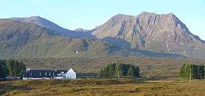
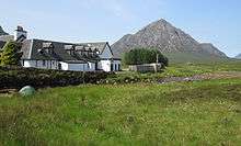
The Kings House Hotel is a remote inn and hotel at the eastern end of Glen Coe at the junction with Glen Etive in the Scottish Highlands. It is sited in an isolated position, about 2 km to the east of the head of the glen towards Rannoch Moor, and faces towards Buachaille Etive Mor which is very popular with rock climbers.
It is called the King's House because British troops were billeted here following the Battle of Culloden in 1746.
History
The Kings House, which is thought to be one of Scotland's oldest licensed inns, was originally built in the 17th century. It was sited at the head of Glen Coe for travelers crossing Rannoch Moor. In the 18th century, the strategic military road crossed the River Etive at this point by the inn. The military route, which was built by the British army in the aftermath of the 1745 Jacobite rising, then headed towards Glen Coe before ascending the Devil's Staircase to Kinlochleven. Parts of the former military route are now used as the West Highland Way.
In late 1746, the buildings became barracks for Crown forces under the command of the Duke of Cumberland . The inn was used as a base by troops conducting operations to crush or capture any remaining Jacobites in the western Highlands.
By the late 18th century, the building had reverted to its original use as a coaching inn serving travellers that came from Ballachulish to Loch Lomond via Tyndrum. In 1803, the inn was visited by Dorothy Wordsworth, the sister of Romantic poet William Wordsworth, who wrote disparagingly:
Never did I see such a miserable, such wretched place, – long rooms with ranges of beds, no other furniture except benches, or perhaps one or two crazy chairs, the floors far dirtier than an ordinary house could be if it were never washed. With length of time the fire was kindled and after another hour of waiting, supper came, a shoulder of mutton so hard that it was impossible to chew the little flesh that might have been scraped off the bones.
However 100 years later, standards had improved dramatically as Dundee MP Alexander Wilkie recorded a pleasant stay:
Arriving at Kings House Inn I have a hearty welcome. Tea, my clothes and shoes dried. Next morning after a walk round I go in for breakfast. What shall I have? – grapefruit? What! can I have grapefruit in Kings House; of course I can; and so I have grapefruit, and porridge and cream, and fish, and everything just like a west end city hotel. I tell you I am well looked after and at a charge so moderate that I am almost ashamed of my appetite.
In 1910, the first visitors with motor vehicles began to come Glen Coe when the stone-shod road was upgraded with tarmac.
Later use
In 1959, the Kings House Hotel underwent its first 20th century modernisation. The work was done in such a sensitive manner that the architect, John Thompson ARIBA of Weddell & Thompson, Glasgow, and unusually, also the builders (at the behest of the architect), Thos. Findlay and Sons Ltd of Mauchline, Ayrshire, both received Civic Trust Awards for their efforts.
The inn continues to offer food and drink. It has 22 bedrooms with suitable facilities for fishermen, walkers and climbers. In winter, the hotel also caters to skiers from the "White Corries" ski resort just across the road on the mountain of Meall a' Bhuiridh.
It is quite common for hikers to camp in the vicinity of Kings House, as the surrounding area is simply open moorland. Although not officially encouraged, provided one stays on the opposite side of the river from the inn, staff are generally welcoming.
Change of hands
New ownership of the property took place in 2015 with the announcement of a refurbishment project.[1]
References
- ↑ "Revamp proposed for Glen Coe's Kings House Hotel". BBC News. 2016-01-06. Retrieved 2016-10-23.
External links
| Wikimedia Commons has media related to Kings House Hotel. |
Coordinates: 56°38′59″N 4°50′23″W / 56.64986°N 4.83969°W