Khao Phanom District
| Khao Phanom เขาพนม | |
|---|---|
| Amphoe | |
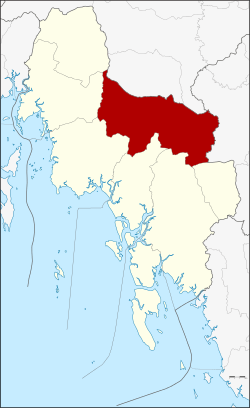 Amphoe location in Krabi Province | |
| Coordinates: 8°15′53″N 99°2′57″E / 8.26472°N 99.04917°ECoordinates: 8°15′53″N 99°2′57″E / 8.26472°N 99.04917°E | |
| Country | Thailand |
| Province | Krabi |
| Seat | Khao Phanom |
| Area | |
| • Total | 788.522 km2 (304.450 sq mi) |
| Population (2548) | |
| • Total | 45,982 |
| • Density | 58.3/km2 (151/sq mi) |
| Time zone | ICT (UTC+7) |
| Postal code | 81140 |
| Geocode | 8102 |
Khao Phanom (Thai: เขาพนม) is a district (amphoe) in Krabi Province, Thailand.
History
The minor district (king amphoe) was created on 1 December 1967 by adding together the tambon Khao Phanom, Khao Din, and two villages of Khok Yang of Mueang Krabi District and tambon Sin Pun from Khlong Thom.[1] It was upgraded to a full district on 29 June 1973.[2]
Geography
Neighboring districts are (from the north clockwise) Chai Buri and Phrasaeng of Surat Thani Province, Thung Yai of Nakhon Si Thammarat Province, and Lam Thap, Khlong Thom, Nuea Khlong, Mueang Krabi, Ao Luek and Plai Phraya of Krabi Province.
The Khao Phanom Bencha National Park protects the forests around Phanom Bencha mountain, which at 1,397 m is the highest elevation in Krabi Province.
Administration
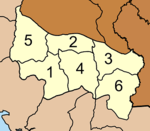
The district is divided into six subdistricts (tambon), which are further subdivided into 54 villages (muban). Khao Phanom is a township (thesaban tambon) which covers parts of the tambon Khao Phanom. Each tambon has a tambon administrative organization (TAO).
|
 |
References
- ↑ ประกาศกระทรวงมหาดไทย เรื่อง แบ่งท้องที่ตั้งเป็นกิ่งอำเภอ (PDF). Royal Gazette (in Thai). 84 (125 ง): 3326. December 26, 1967.
- ↑ พระราชกฤษฎีกาตั้งอำเภอเขาพนม อำเภอสนามชัยเขต อำเภอแม่อาย อำเภอขามสะแกแสง อำเภอเก้าเลี้ยว อำเภอโพธิ์ประทับช้าง อำเภอหนองพอก อำเภอละอุ่น อำเภอทุ่งหว้า และอำเภอศรีธาตุ พ.ศ. ๒๕๑๖ (PDF). Royal Gazette (in Thai). 90 (75 ก special): 32–36. June 28, 1973.