Ko Lanta District
| Ko Lanta เกาะลันตา | |
|---|---|
| Amphoe | |
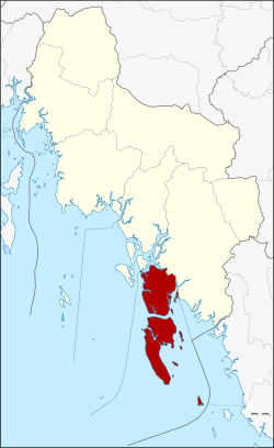 Amphoe location in Krabi Province | |
| Coordinates: 7°39′20″N 99°2′31″E / 7.65556°N 99.04194°ECoordinates: 7°39′20″N 99°2′31″E / 7.65556°N 99.04194°E | |
| Country | Thailand |
| Province | Krabi |
| Seat | Saladan |
| Area | |
| • Total | 339.843 km2 (131.214 sq mi) |
| Population (2012) | |
| • Total | 30,500 |
| • Density | 81.4/km2 (211/sq mi) |
| Time zone | ICT (UTC+7) |
| Postal code | 81150 |
| Geocode | 8103 |
Ko Lanta (Thai: เกาะลันตา, also Koh Lanta) is a district (amphoe) in Krabi Province, Thailand.
History
The district was established in December 1901. It consists of four island groups : Mu Ko Lanta (170 km2), Mu Ko Klang (162 km2), Mu Ko Rok (3.5 km2), and Mu Ko Ngai (3.6 km2). Other island groups are smaller, like Mu Ko Haa.
The origin of the name is unclear, but it may originate from the Javanese word "lantas", meaning a type of grill for fish. The name of the island was officially changed to "Lanta" in 1917.
It is believed that the area was one of the oldest communities in Thailand, dating back to the prehistoric period. It is believed that this province may have taken its name after the meaning of Krabi, which means "sword". This may have stemmed from a legend that an ancient sword was unearthed prior to the city's founding.
Geography

The district, approximately 70 km from Krabi town, consists of three major islands. The first, Ko Klang, is separated from the mainland by a small river (klong) and road bridge, and is often mistakenly thought of as part of mainland Krabi Province. Of the two remaining larger islands, the largest, more populated Ko Lanta Yai (commonly known as simply "Ko Lanta") and the smaller Ko Lanta Noi, together with 50 other smaller islands make up the 52-island Mu Ko Lanta National Park. The largest island (Ko Lanta Yai) has nine white sandy beaches running down the entire west coast, forests, and tropical jungle. The geography of the island is typically mangroves; coral rimmed beaches; and tree-covered hills. A popular tourist destination, the islands are known for their long, sandy beaches and scuba diving.[1] Ko Lanta Yai and Ko Lanta Noi are connected with a bridge (opened in 2016). The bridge has led to many tourist projects on the undeveloped island. The first tourist facility on Ko Lanta Noi will open in 2017.
Neighboring districts are Nuea Khlong to the northwest and Khlong Thom to the northeast and east.
Mu Ko Lanta National Park, established in 1990 as the 62nd national park of Thailand, occupies 134 km2 of the district.[2]
Climate
| Climate data for Ko Lanta (1981–2010) | |||||||||||||
|---|---|---|---|---|---|---|---|---|---|---|---|---|---|
| Month | Jan | Feb | Mar | Apr | May | Jun | Jul | Aug | Sep | Oct | Nov | Dec | Year |
| Record high °C (°F) | 35.9 (96.6) |
37.2 (99) |
38.0 (100.4) |
38.5 (101.3) |
38.0 (100.4) |
35.0 (95) |
35.0 (95) |
34.5 (94.1) |
34.0 (93.2) |
34.0 (93.2) |
34.7 (94.5) |
35.0 (95) |
38.5 (101.3) |
| Average high °C (°F) | 32.7 (90.9) |
33.7 (92.7) |
34.1 (93.4) |
33.9 (93) |
32.5 (90.5) |
31.8 (89.2) |
31.5 (88.7) |
31.2 (88.2) |
30.8 (87.4) |
30.9 (87.6) |
31.0 (87.8) |
31.2 (88.2) |
32.1 (89.8) |
| Daily mean °C (°F) | 27.6 (81.7) |
28.2 (82.8) |
28.8 (83.8) |
29.0 (84.2) |
28.7 (83.7) |
28.5 (83.3) |
28.2 (82.8) |
28.2 (82.8) |
27.6 (81.7) |
27.3 (81.1) |
27.1 (80.8) |
26.9 (80.4) |
28.0 (82.4) |
| Average low °C (°F) | 23.9 (75) |
24.1 (75.4) |
24.6 (76.3) |
25.0 (77) |
25.3 (77.5) |
25.4 (77.7) |
25.0 (77) |
25.2 (77.4) |
24.8 (76.6) |
24.4 (75.9) |
24.1 (75.4) |
23.6 (74.5) |
24.6 (76.3) |
| Record low °C (°F) | 19.0 (66.2) |
18.9 (66) |
20.0 (68) |
21.5 (70.7) |
22.4 (72.3) |
22.0 (71.6) |
21.7 (71.1) |
20.5 (68.9) |
21.7 (71.1) |
21.2 (70.2) |
21.0 (69.8) |
19.5 (67.1) |
18.9 (66) |
| Average rainfall mm (inches) | 14.9 (0.587) |
18.0 (0.709) |
60.3 (2.374) |
119.0 (4.685) |
244.8 (9.638) |
258.5 (10.177) |
296.3 (11.665) |
304.2 (11.976) |
330.3 (13.004) |
325.4 (12.811) |
147.1 (5.791) |
55.6 (2.189) |
2,174.4 (85.606) |
| Average rainy days | 2.7 | 1.9 | 5.0 | 10.2 | 16.8 | 17.1 | 17.4 | 17.7 | 20.1 | 21.1 | 14.5 | 8.4 | 152.9 |
| Average relative humidity (%) | 75 | 74 | 76 | 79 | 85 | 85 | 85 | 85 | 85 | 85 | 85 | 79 | 82 |
| Mean monthly sunshine hours | 198.4 | 183.6 | 186.0 | 147.0 | 114.7 | 111.0 | 114.7 | 114.7 | 108.0 | 111.6 | 105.0 | 179.8 | 1,674.5 |
| Mean daily sunshine hours | 6.4 | 6.5 | 6.0 | 4.9 | 3.7 | 3.7 | 3.7 | 3.7 | 3.6 | 3.6 | 3.5 | 5.8 | 4.6 |
| Source #1: Thai Meteorological Department[3] | |||||||||||||
| Source #2: Office of Water Management and Hydrology, Royal Irrigation Department (sun and humidity)[4] | |||||||||||||
Administration
The district is divided into five subdistricts (tambon), which are further subdivided into 37 villages (muban). Ko Lanta Yai has township (thesaban tambon) status and includes part of tambon Ko Lanta Yai.
|
 |
Islands
| Nr | Island | Capital | Settlements | Area (km²) | Population[lower-alpha 1] |
|---|---|---|---|---|---|
| 1 | Ko Bu Bu | Had Na Koh | Southern Beach, Northern Beach | 0.123 | 5 |
| 2 | Ko Ngai (Lanta) | Ban Ko Hai | Laem Lanang, Ao Tapang, Laem Baewa, Ao Muang, Ao Ko Tong, Laem Daeng, Laem Laya, Ao Nako | 3.586 | 100 |
| 3 | Ko Klang | Huahin (Lanta) | Pak Khlong, Khlong Yang, Tha Klong | 165 | 13,700 |
| 4 | Ko Lanta Noi | Ban Lanta Noi | Langsod, Klong Mak, Tha Rai, Hua Laem Ngu, Klong Tanod, Thung, Ro Yai, Laem Palm | 75 | 5,350 |
| 5 | Ko Lanta Yai | Saladan | Thung Yee Pheng, Ban Lanta Yai, Hua Laem, Sung Gau, Ao Tanod, Pra-Ae, Klong Kwang | 80.82 | 10,830 |
| 6 | Ko Mai Ngam | 1.95 | 0 | ||
| 7 | Ko Pleo | Ko Pleo | 0.16 | 10 | |
| 8 | Ko Por | Ko Por | Ao Tha Kang, Ao Nai Ban | 1.6 | 500 |
| 9 | Ko Rapule | 1 | 0 | ||
| 10 | Ko Talabeng | Ao Kua Koh | Ao Talay Waek, Ao Bon | 2.04 | 2 |
| 11 | Ko Waen | 0.17 | 0 | ||
| 12 | Ko Wan Tia | 1.44 | 0 | ||
| 13 | Mu Ko Rok | Laem Thong | Ao San Chao, Hat Thalu, Ao Man Sai, Hat Tarua, Laem Sayam | 3.48 | 5 |
| 14 | Mu Ko Haa | Ko Haa Sam Lagoon | The Chimney Point, Whip Coral Point, Ko Haa Yai coral beach, The Cathedral | 0.16 | 0 |
| 15 | Mu Ko Maa | Ko Maa | 0.1 | 0 | |
| 16 | More Islands | Ko Raputang, Ko Kam Yai, Ko Kam Noi, Ko Klaueng | 2 | 0 | |
| Ko Lanta District | Ban Saladan | 339.7 | 30,500 |
Transportation
Air The nearest airports are at Krabi, Trang, and Phuket. Krabi Airport, the most popular one for travel to Ko Lanta, is approximately 10 km from the provincial town and operates international flights to several foreign destinations.
Roads There are only two main roads on Ko Lanta, one in the northeast and another in the southwest, which runs parallel to the beach. On Ko Lanta Noi there is just one main road in the east and a smaller one that links to the ferry pier. On the mainland, Highway 4206 connects with Khlong Thom District, passing Khlong Yang and Koh Klang sub-districts to a public car ferry at Baan Hua Hin. To get from the mainland of Thailand to Ko Lanta Yai, two public car ferries must be taken. A bridge connecting Ko Lanta to the mainland is currently under construction.
Ferries There are regular, daily ferry boats operating between Ko Lanta and Krabi, Phuket, and Ko Phi Phi. A ferry run by Phetpaily departs daily from Klongdao Pier on Ko Lanta to Ko Ngai and Ko Mook.
Longtail boat Tourists may hire longtail boats to take them to nearby islands.
Motorbike These can be either hired or taxied out. The island is full of both motorbike rental places and motorbike-taxi drivers.
Songthaew Songthaews run up and down the main roads and have fixed fares. This is a very common means of transport for locals.
Train The nearest train station is in Trang Province just south of Krabi. From there, there are trains to and from Bangkok.
Tourism
Attractions
- Ko Lanta National Park – Covering a total area of 135 square kilometres is in Amphoe Ko Lanta and consists of many islands. The two major islands are Ko Lanta Yai (เกาะลันตาใหญ่) and Ko Lanta Noi (เกาะลันตาน้อย)
- Lanta Old Town – Culturally diverse with Chinese merchants, original Thai fishing families, and an ancient Sea Gypsy community. Many years ago, Ko Lanta's Old Town acted as the port and commercial center for the island and provided a safe harbor for Arabic and Chinese trading vessels sailing between the larger ports of Phuket, Penang, and Singapore.
- Khao Mai Kaew Caves – These caves, in the centre of the island, house impressive stalactites and stalagmites. Some of the caves are just very large and one contains a pool.
- Sea Gypsy Village – Known to the Thais as "chao-le", sea gypsies have occupied the area for hundreds of years, settling along the coast in stilted houses erected in the sea. They are unique in that they mix very little with the general population, speak their own language, and have their very own traditional beliefs and rituals.
Activities

Scuba Diving The diving surrounding Ko Lanta are considered by many to be among some of the best the country has to offer. There is a variety of fringing reefs, marine life, caves, rocks, and islets.
Hin Daeng and Hin Muang near Ko Lanta are perhaps the best dive sites in Thailand (ranking in the world's top ten) with more than 200 hard corals and 108 reef fish catalogued in a study underway, but thousands more organisms abound. Hin Daeng has the steepest and deepest in the whole of the country with beautiful marine life. Hin Muang next door is completely underwater and it is covered with delicate violet coral. The sites also have one of the world's highest incidences of manta ray sightings, with fairly frequent whale sharks.
The Ko Haa Archipelago, across from Ko Lanta in the Andaman Sea, offers some of the best conditions for beginner to advanced divers, with good visibility and underwater landscapes, with its underwater caverns and abundance of soft coral.
Snorkeling Snorkeling can be done around the three islands, Ko Haa, Ko Bida, and Ko Rok, all accessible from Ko Lanta via speedboat or longtail boat.
Fishing Fishers usually catch the likes of marlin, sailfish barracuda, red snapper, and tuna during a longtail boat trip having a choice of either day fishing or night fishing.
Kayaking The east side of Ko Lanta with its rich mangroves is the most suitable for kayaking in peace and quiet while admiring the natural surroundings. Kayaking is also the best way to explore caves. Kayaking can also be done in mangrove swamps at Baan Tungyeepeng and Ko Talabaeng, the limestone cliff near Ko Lanta.
Hiking Ko Lanta's forests with excellent flora and fauna are suitable for hiking. Elephant rides are usually arranged to take visitors to the top of the hill in Ko Lanta National Park.
Thai boxing There is one small boxing stadium on the island which hosts regular events. It also holds training camps, which are popular among tourists who wish to learn Thai boxing.
Thai cooking Thai cooking courses on Ko Lanta offer foreign tourists the chance to learn to cook their favourite dishes such as tom yum kung, sweet green curry, and chicken with cashew nuts.
Spa Traditional Thai massage is aimed at enhancing not only one's physical and emotional state but also to allow one to grow spiritually. There are many spas on this island. Massage on the beach is also possible.
Local products
Batik Even though it is Indonesian in origin, the art of batik has embedded itself in the local culture. There are also a lot of handicrafts such as pineapple paper.
Local Culture
Krabi and Ko Lanta incorporate a mix of Buddhists, Thai-Chinese, Muslims, and sea gypsies. The majority of the population in rural areas is Muslim. The area, however, has no apparent religious tension. Most of them speak with a thick Southern dialect that is difficult for even other Thais to understand. Given this multiculturalism, Krabi is always celebrating something, be it Thai Buddhist, Thai-Chinese, or Thai-Islamic tradition. Chao-le (sea gypsies) inhabit Ko Lanta and follow a lifestyle that has been relatively unaffected by the islands' tourism.
Events & Festivals
- Krabi Boek Fa Andaman Festival (งานกระบี่เบิกฟ้าอันดามัน) Held annually in November to inaugurate the tourist season. Water sports competitions, cultural shows, and good-natured fun are on the schedule.
- Laanta Lanta Festival (เทศกาลลานตา ลันตา) The festival is usually held in March every year in Lanta Old Town, which has a history of more than 100 years. Old Chinese-style houses can still be seen here. In this festival, tourists can see the traditional culture, previously unseen ceremonial demonstrations, local performances, folk games, water sports competitions, and enjoy the tastes from various kinds of food booths which are provided by hotels on the island.
- Loi Ruea Chao-Le Festival (ประเพณีลอยเรือชาวเล) This old ritualistic tradition takes place on Ko Lanta during the full moon of the sixth and eleventh month in the lunar calendar. This is a religious rite performed by the sea gypsies of Ko Lanta, as well as neighbouring areas, who gather on the beach near Sala Dan Village. They dance their famous "rong ngeng" round the boats of misfortune to be set adrift. Ceremonies feature singing and dancing. This festival is held to bring prosperity and happiness to the participants.
- Sat Duean Sip Festival or Festival of the Tenth Lunar Month (งานประเพณีสารทเดือนสิบ) This is the southern traditional merit-making occasion to honour one's ancestors. Food offerings such as khanom la, khanom chohu, khanom phong, khanom ba, and khanom kong or khai pla, are made offer to Buddhist monks.
- Chak Phra Festival (งานประเพณีชักพระ) The original waterborne procession, where images of Buddha are put on elaborately decorated pulpits on boats pulled along the river, has been replaced by a land procession. The festival was formerly accompanied with a performance of traditional boat songs, but they have since disappeared.
Art
- Likae Pa (ลิเกป่า) An adapted play, Likae Pa follows the adventures of an Indian merchant from Calcutta who married a local girl named Yayi. The story is then followed by other plays. Likae Pa is accompanied by the music of folk instruments such as various kinds of drums, cymbals, and gongs. The lyrics are a mixture of the traditional Manora and Buranyawa songs. With its long history of popularity in Krabi, Like Pa performers are abundant here. It is believed that the play originated in this province.
- Shadow Plays (หนังตะลุง)This is an Indian influence. There are many shadow play or nang talung companies in Krabi.
- Manora (มโนราห์) This is a dance performance, native to southern Thailand, which reflects its traditional culture.
- Rong Ngeng (รองเง็ง) and Phleng Tanyong (เพลงตันหยง) A Malaysian adaptation, of Portuguese origin, rong ngeng is a traditional folk dance and music customarily performed in noble houses. It was later performed by the locals with Thai lyrics called phleng tanyong.
Food
Much of the cuisine has its origins in Malay, Indonesian, and Indian food. Favourite dishes from the south include Indian-style Muslim curry (massaman), rice noodles in fish curry sauce (khanom chin), and khao mok kai (chicken biryani). Pad Thai is one of the most favoured dishes and is available throughout the island group.
The dog conch or wing shell (หอยชักตีน) fish is famous in Krabi's cuisine. Stir fried Spotted Babylon (หอยหวาน), a snail which is found in mangrove forests, with chilies and basil, is also famous.
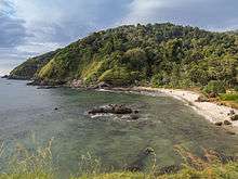
Gallery
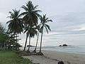 Ko Lanta Beach
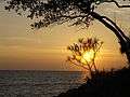 Ko Lanta
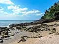 Ko Lanta, beach
 Ko Lanta, rocky coast
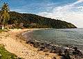 Ko Lanta
.jpg) Beach house, Ko Lanta
Beach house, Ko Lanta
Notes
- ↑ Island's area and population retrieved from the 2012 census
References
- ↑ "Koh Lanta". Tourism Authority of Thailand (TAT). Retrieved 22 June 2015.
- ↑ "Mu Ko Lanta National Park". Department of National Parks (DNP) Thailand. Retrieved 22 June 2015.
- ↑ "Climatological Data for the Period 1981–2010". Thai Meteorological Department. p. 28. Retrieved 8 August 2016.
- ↑ "ปริมาณการใช้น้ำของพืชอ้างอิงโดยวิธีของ Penman Monteith (Reference Crop Evapotranspiration by Penman Monteith)" (PDF) (in Thai). Office of Water Management and Hydrology, Royal Irrigation Department. p. 118. Retrieved 8 August 2016.
External links
-
 Ko Lanta travel guide from Wikivoyage