Kelebia
| Kelebia | |
|---|---|
| Country |
|
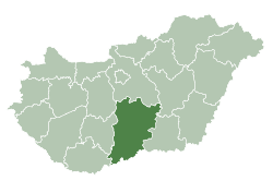
| County | Bács-Kiskun |
| Area | |
| • Total | 66.70 km2 (25.75 sq mi) |
| Population (2002) | |
| • Total | 3,019 |
| • Density | 45/km2 (120/sq mi) |
| Time zone | CET (UTC+1) |
| • Summer (DST) | CEST (UTC+2) |
| Postal code | 6423 |
| Area code(s) | 77 |

Location of Bács-Kiskun
county in Hungary
Kelebia is a village in Bács-Kiskun county, in the Southern Great Plain region of southern Hungary. The railway crossing into the Serbian province of Vojvodina is located here.
Croats in Hungary call this village Kelebija. [1]
History

Passport exit stamp from Kelebia via railway crossing.
The border drawn in 1918 split one village into two countries, Hungary and Kingdom of Serbs, Croats and Slovenes. Today, the towns are called Kelebia in Hungary and Kelebija in Serbia.
Geography
It covers an area of 66.7 km2 (26 sq mi) and has a population of 3019 people (2002).
References
- ↑ (Croatian) "Folia onomastica croatica 14/2005.". (462 KB) Živko Mandić: Hrvatska imena naseljenih mjesta u Madžarskoj,
External links
- (Hungarian) Kelebia Község Honlapja Főoldal
Coordinates: 46°12′N 19°37′E / 46.200°N 19.617°E
This article is issued from Wikipedia - version of the 11/17/2016. The text is available under the Creative Commons Attribution/Share Alike but additional terms may apply for the media files.