Kavallari, Ioannina
| Kavallari Καβαλλάρι | |
|---|---|
|
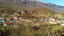
General view of Kavallari | |
 Kavallari | |
| Coordinates: 39°44.55′N 20°54.85′E / 39.74250°N 20.91417°ECoordinates: 39°44.55′N 20°54.85′E / 39.74250°N 20.91417°E | |
| Country | Greece |
| Administrative region | Epirus |
| Regional unit | Ioannina |
| Municipality | Zagori |
| Municipal unit | East Zagori |
| Elevation | 640 m (2,100 ft) |
| Community[1] | |
| • Population | 78 (2011) |
| • Area (km2) | 21.031 |
| Time zone | EET (UTC+2) |
| • Summer (DST) | EEST (UTC+3) |
| Postal code | 455 00 |
| Area code(s) | +30-2656-xxx-xxx |
| Vehicle registration | ΙΝx-xxxx |
Kavallari (Greek: Καβαλλάρι) is a village and a community of the Zagori municipality.[2] Before the 2011 local government reform it was part of the municipality of East Zagori, of which it was a municipal district.[2] The 2011 census recorded 78 inhabitants in the village.[1] The community of Kavallari covers an area of 21.031 km2.[3]
See also
References
- 1 2 "Απογραφή Πληθυσμού - Κατοικιών 2011. ΜΟΝΙΜΟΣ Πληθυσμός" (in Greek). Hellenic Statistical Authority.
- 1 2 Kallikratis law Greece Ministry of Interior (Greek)
- ↑ "Population & housing census 2001 (incl. area and average elevation)" (PDF) (in Greek). National Statistical Service of Greece.
This article is issued from Wikipedia - version of the 11/6/2016. The text is available under the Creative Commons Attribution/Share Alike but additional terms may apply for the media files.