Katy Trail State Park
| Katy Trail | |
|---|---|
|
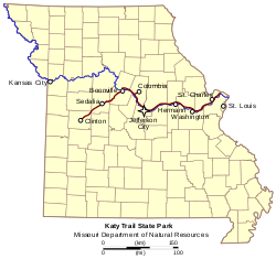
The Katy Trail (red) and the Missouri River (blue) on a map of Missouri | |
| Length | 237.7 mi (382.5 km) |
| Location | Missouri, United States |
| Trailheads |
Machens, Missouri Clinton, Missouri |
| Use | Hiking, Cycling, Horseback |
| Elevation | |
| Elevation change | negligible |
| Highest point | Windsor, Missouri |
| Lowest point | St. Charles, Missouri |
| Hiking details | |
| Trail difficulty | Easy |
| Season | All |
| Sights | Missouri River, Manitou bluffs |
| Hazards |
Severe weather Poison ivy Snakes |
| Website | Katy Trail State Park |


The Katy Trail State Park is a state park in the U.S. state of Missouri that contains the Katy Trail, a recreational rail trail that runs 240 miles (390 km) in the right-of-way of the former Missouri–Kansas–Texas Railroad.[1] Running largely along the northern bank of the Missouri River, it is the country's longest Rails-to-Trails trail.[2] The trail is open for use by hikers, joggers, and cyclists year-round, from sunrise to sunset. Its hard, flat surface is of "limestone pug" (crushed limestone).
The nickname "Katy" comes from the phonetic pronunciation of 'KT' in the railroad's abbreviated name, MKT. Sections of the Katy are also part of the Lewis and Clark National Historic Trail and the American Discovery Trail.
History
Conversion of right-of-way to a trail was made possible by the National Trails System Act of 1968. In 1982, the city of Columbia opened the MKT Trail on an abandoned spur of the Katy as one of the first rails-to-trails pilot projects in the United States.
On October 4, 1986, floodwater from the Missouri River severely damaged the track along the Missouri–Kansas–Texas Railroad's route from Sedalia to Machens, Missouri. The route had been washed out and repaired many times, but this time, railroad officials decided not to return the tracks to service. Trains were re-routed, and the right-of-way was to be abandoned. The Missouri Department of Natural Resources purchased the right-of-way with a donation from Edward D. "Ted" Jones and Pat Jones of Williamsburg and St. Louis. In 1990, the first segment of the trail officially opened in Rocheport.[3]
In 1991, the Union Pacific Railroad donated 33 miles (53 km) of right-of-way from Sedalia to Clinton.
The trail was initially planned for completion in 1994. However, the Great Flood of 1993 damaged 75 miles (121 km) of the original 126 miles (203 km) of the trail. The completed trail from St. Charles to Sedalia was finally opened in 1996; the section from Sedalia to Clinton opened in 1999.[4][1]
In 2011. the trail was expanded to include the corridor from St. Charles to Machens.[5]
Trail networks
Work is underway to open Rock Island Trail State Park by the end of 2016. The Rock Island Trail will connect to the Katy Trail in Windsor and thereby extend the route to the suburbs of Kansas City at Pleasant Hill on rail banked right-of-way of the Chicago, Rock Island and Pacific Railroad.[6] [7] A settlement to allow the use of the Rock Island corridor was reached between Missouri Governor Matt Blunt and Ameren as partial compensation for a flood which devastated Johnson's Shut-ins State Park after the failure of a dam owned by Ameren.[8] Efforts are being made to obtain additional right-of-way to bring the Rock Island Trail into Kansas City proper.
Plans are underway to add another 144-mile (232 km) unused section of the Chicago, Rock Island and Pacific to Rock Island Trail State Park, which, with the Katy, would create a 450-mile (720 km) trail network.[9] [10] The extension would run from Windsor to Beaufort, near Washington. Hope is to be able to then extend the trail into Washington from where it could cross the Missouri River to connect to the Katy Trail again, completing a cross-state loop.
There is also an effort to create a four-state trail system using several trails already in existence including the Katy. This "quad state" trail would connect Missouri, Kansas, Iowa, and Nebraska.[11]
Route
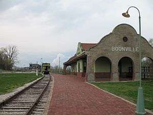
The Katy Trail currently begins at Machens (mile-marker 27) on the Missouri River and runs along the northern bank of the river for most of the trail's length. The next major city along the trail is Jefferson City — the state capital. At mile-marker 169.9 (McBaine) the trail intersects the MKT Trail which leads into downtown Columbia, the largest city along the trail. The Katy then deviates from its original path and crosses the Missouri River at Boonville on the Boonslick Bridge instead of the original MKT Bridge. From here the trail runs to its terminus in Clinton at mile-marker 264.6.[12]
Issues
The MKT bridge at Boonville
The Katy Trail is part of the U.S. railbank, which means it must remain connected to the national railway network so that it could be returned to active railway use. The segment of the trail between St. Charles and Sedalia was connected in two locations. One of these connections is in St. Charles and the other was provided by the Missouri–Kansas–Texas Bridge at Boonville. The Missouri Department of Natural Resources was granted the right to keep the bridge in place and to use it at the MDNR's discretion as part of the trail under the Interim Trail Agreement of June 25, 1987. But on April 28, 2005, the Missouri Department of Natural Resources amended the agreement, abandoning its rights to the bridge and allowing Union Pacific to remove the bridge and thus creating two independent segments in the trail, east and west of Boonville. If the connection in St. Charles is destroyed or otherwise rendered unusable by rail (such as by natural disaster), the segment of the trail between St. Charles and Boonville would lose its railbanked status and ownership of the land would probably revert to its original owners from before the MKT Line was built. The same could happen to the segment east of Boonville if its connection is lost.
On February 4, 2010, Missouri Governor Jay Nixon announced that Union Pacific Railroad would give the bridge to the city of Boonville, MO, ending a nearly six-year dispute over the bridge and the trail.[13] The city announced it would restore the bridge and incorporate it back into the Katy Trail bicycle and hiking trail.[14]
References
- 1 2 "Trail History and Features at Katy Trail State Park". Missouri Department of Natural Resources. Retrieved 2012-05-04.
- ↑ "Katy Trail State Park". Rails-to-Trails Conservancy. Retrieved 2012-04-17.
- ↑ "Event marks Katy Trail's 20th anniversary". Columbia Missourian. 29 March 2010. Retrieved 4 May 2012.
- ↑ "MKT Nature and Fitness Trail History". City of Columbia, Missouri.
- ↑ Schlinkmann, Mark (2 April 2011). "Long-delayed Katy Trail section reopens". St. Louis Post Dispatch. Retrieved 4 May 2012.
- ↑ "Missouri on pace to complete 47.5-mile extension of Katy Trail from Windsor to Pleasant Hill, Gov. Nixon announces". Office of Missouri Governor Jay Nixon. 2015-09-17. Retrieved 2016-02-23.
- ↑ "Kansas City extension closer to reality". BikeKatyTrail.com.
- ↑ "AmerenUE settlement includes money for Katy Trail". Joplin Independent. 29 November 2007. Retrieved 2 January 2009.
- ↑ "Frequently Asked Questions about the Rock Island Corridor from Windsor to Beaufort" (PDF). Missouri Department of Natural Resources. Retrieved 2016-02-23.
- ↑ "Missouri's planned Rock Island Trail gets a federal boost". Kansas City Star. 2015-02-27. Retrieved 2016-02-23.
- ↑ Hugh, Brent (June 30, 2005). "Quad-state trail system mapped--over 700 miles of trail linking MO, KS, NE, IA". Missouri Bicycle & Pedestrian Federation. Retrieved October 3, 2012.
- ↑ "Clinton Trailhead, Mile Marker 264.6". Katy Trail State Park. Missouri State Parks. Retrieved 2012-04-17.
- ↑ "Gov. Nixon announces agreement-in-principle that will preserve historic Katy bridge at Boonville" (Press release). Office of Missouri Governor. February 4, 2010. Retrieved September 26, 2014.
- ↑ Berger, Eric (February 5, 2010). "Missouri governor Nixon announces Katy Bridge will stay in Boonville". Boonville Daily News. Boonville, Mo.: GateHouse Media. Archived from the original on July 8, 2011. Retrieved September 26, 2014.
External links
| Wikimedia Commons has media related to Katy Trail State Park. |
- Katy Trail State Park Missouri Department of Natural Resources
- The Katy Trail RailsToTrails.us
- BikeKatyTrail.com
- Katy Trail Merchants & Communities
- Katy Trail Map (user generated)