Kahal
For historical Jewish quasi-governmental bodies, see Qahal. For the villages in Iran, see Kahal, Iran.
| Kahal | |
|---|---|
 | |
 Kahal | |
| Coordinates: 32°53′30.48″N 35°30′34.55″E / 32.8918000°N 35.5095972°ECoordinates: 32°53′30.48″N 35°30′34.55″E / 32.8918000°N 35.5095972°E | |
| District | Northern |
| Council | Mevo'ot HaHermon |
| Affiliation | Moshavim Movement |
| Founded | 1980 |
| Population (2015)[1] | 358 |
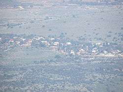
Kahal (Hebrew: כָּחָל) is a moshav in the Galilee near Highway 85 in northern Israel. Located on the border of the Upper Galilee and Lower Galilee, north of Lake Kinneret and just northwest of Tabgha, it falls under the jurisdiction of Mevo'ot HaHermon Regional Council. In 2015 it had a population of 358.
References
- ↑ "List of localities, in Alphabetical order" (PDF). Israel Central Bureau of Statistics. Retrieved 16 October 2016.
This article is issued from Wikipedia - version of the 8/31/2016. The text is available under the Creative Commons Attribution/Share Alike but additional terms may apply for the media files.