Kłobuck
| Kłobuck | |||
|---|---|---|---|
|
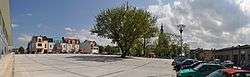
Market square in Kłobuck | |||
| |||
 Kłobuck | |||
| Coordinates: 50°55′N 18°56′E / 50.917°N 18.933°E | |||
| Country |
| ||
| Voivodeship | Silesian | ||
| County | Kłobuck County | ||
| Gmina | Gmina Kłobuck | ||
| Area | |||
| • Total | 47.53 km2 (18.35 sq mi) | ||
| Highest elevation | 284 m (932 ft) | ||
| Lowest elevation | 240 m (790 ft) | ||
| Population (2010) | |||
| • Total | 13,085 | ||
| • Density | 280/km2 (710/sq mi) | ||
| Postal code | 42-100 | ||
| Climate | Cfb | ||
| Website | http://www.gminaklobuck.pl | ||

Kłobuck [ˈkwɔbut͡sk] (German: Klobutzko) is a town in Poland, with 13,193 inhabitants (2009). Located in the Silesian Voivodeship, about 15 km northwest of Częstochowa, it is the capital of Kłobuck County. Historically, Kłobuck belongs to Lesser Poland, and is located in its extreme northwestern corner, near the border with two other Polish historical provinces - Greater Poland, and Silesia. Kłobuck is part of urban agglomeration of Częstochowa. The town lies among the hills of Lesser Poland Upland. Most of Kłobuck lies 240 to 260 metres above sea level, and the highest point within town’s limits is Dębowa Góra (284 metres). Kłobuck has the area of 47 km2., with forests taking up 20%.
Geography
Kłobuck is located on the border of two mesoregions: Wieluń Upland and Krzepice Slip, which form a part of Wieluń-Woźniki Upland. Kłobuck is located by the Biała Oksza river and Czarna Oksza river.
Landscape The city is located on a hilly fragment of Woźniki-Wieluń Upland. The highest point within the town's limits is Dębowa Góra - 284 meters above the sea level.
Land use Kłobuck has an area of 47,46 km². About 71% of the area is used for agricultural purposes (mostly for arable farming and grazing). About 20% of the town's area is forested, whilst 9% of the land is covered by houses, industrial estates and infrastructure such as roads.
Nature Dębowa Góra nature reserve is located within the town's limits, 2 km from the town centre. This nature reserve gives special protection to the remains of primeval oak and hornbeam forests. Most of the forests within Kłobuck's limits are a part of the Kłobuck forest district (Nadleśnictwo Kłobuck).There are no big natural bodies of water within the town's limits. The Zakrzew reservoir is located on the border of Rybno village and Kłobuck.
History
Kłobuck was granted town rights in 1339, during the reign of King Casimir III the Great. At that time, it was located along the busy merchant road from Lesser Poland to Greater Poland. Further north, near Wieluń, the road split into two directions - northwest to Poznań, and southwest to Wrocław. According to Jan Długosz, who himself was a canon at Kłobuck, the local St Martin and Margaret Church was built in 1144. Kłobuck was a major local trade center well before receiving its official status as a town. It had a number of artisans, and in 1658 it became the seat of a starosta. For hundreds of centuries, until 1793 (see Partitions of Poland), the town belonged to Lelów County of Kraków Voivodeship. Annexed by the Kingdom of Prussia, it briefly was part of New Silesia. In 1807 Kłobuck was incorporated into the Duchy of Warsaw, sharing its fate in the Russian Empire. Between 1870-1917 Kłobuck was a village, upon order of Tsarist authorities.
In the Second Polish Republic, Kłobuck belonged to Częstochowa County of Kielce Voivodeship. In May 1939, National Defence Battalion “Kłobuck” was formed here. On September 1, 1939, the Battle of Mokra took place 5 kilometres north of Kłobuck. During World War II, the town was incorporated into the Third Reich, as part of the County of Blachownia (German: Landkreis Blachstädt), Upper Silesia Province. Most of Kłobuck's 2,000 Jews were murdered in the Holocaust.
In the immediate postwar period, Kłobuck returned to Kielce Voivodeship, but in 1950, together with Częstochowa, it was moved to Katowice Voivodeship. In 1952, Kłobuck County was created, and in 1975 - 1999, the town belonged to Częstochowa Voivodeship. After the war, Kłobuck quickly developed in the 1950s and 1960s, when several heavy industry enterprises were opened, and iron ore deposits were found.
Main object of interest is the Church of Saint Martin and Mary Magdalene. First wooden church in that location was built in 1144. A monastery was founded there in 1476, and contemporary church is Gothic-style with Baroque elements. In the district of Zagórze there is a palace, built in the late 18th and early 19th centuries. Like other towns located in the Middle Ages, Kłobuck has a market square, which was renovated in 2009 - 2010.
Transport
Main road connections from the Kłobuck include connection with Wieluń (to the north-west) and Częstochowa (to the south-east) via the National Road ![]() . Kłobuck also has a rail station, along Polish Coal Trunk-Line, which since 2006 has been used freight trains only.
. Kłobuck also has a rail station, along Polish Coal Trunk-Line, which since 2006 has been used freight trains only.
Etymology
In the past, the name of the town was spelled in many different ways - Kłobucko, Kłobuczko, Kłobuczek. Current name has been used since the late 19th century, and it most probably comes from ancient Polish word kłobuk, which is a type of headgear. Another explanation is that kłobuk means “top”, or “summit”, and at the time of its location, the town was on the top of Lesser Poland, as its most extreme northwestern urban centre.
Gallery
 Town square
 Palace in Zagórze
 St Marcin and Małgorzata Church
 National Insurance building
External links
| Wikimedia Commons has media related to Kłobuck. |
- Webpage about the city
- Information about local authority
- Kłobuck County webpage
- The Jewish community life in Kłobuck before WW II
- Jewish Community in Kłobuck on Virtual Shtetl
Coordinates: 50°54′N 18°56′E / 50.900°N 18.933°E
Seat: Kłobuck | ||
| Urban-rural gminas |  | |
| Rural gminas | ||
| Town and seat |  | |
|---|---|---|
| Villages | ||