Junction City, Missouri
| Junction City, Missouri | |
|---|---|
| Village | |
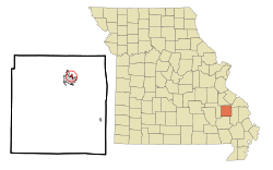 Location of Junction City, Missouri | |
| Coordinates: 37°34′11″N 90°17′13″W / 37.56972°N 90.28694°WCoordinates: 37°34′11″N 90°17′13″W / 37.56972°N 90.28694°W | |
| Country | United States |
| State | Missouri |
| County | Madison |
| Area[1] | |
| • Total | 0.36 sq mi (0.93 km2) |
| • Land | 0.36 sq mi (0.93 km2) |
| • Water | 0 sq mi (0 km2) |
| Elevation | 741 ft (226 m) |
| Population (2010)[2] | |
| • Total | 327 |
| • Estimate (2012[3]) | 332 |
| • Density | 908.3/sq mi (350.7/km2) |
| Time zone | Central (CST) (UTC-6) |
| • Summer (DST) | CDT (UTC-5) |
| ZIP code | 63645 |
| Area code(s) | 573 |
| FIPS code | 29-37736[4] |
| GNIS feature ID | 0752400[5] |
Junction City is a village in Madison County, Missouri, United States. The population was 327 at the 2010 census.
Geography
Junction City is located at 37°34′11″N 90°17′13″W / 37.569631°N 90.286815°W.[6]
According to the United States Census Bureau, the village has a total area of 0.36 square miles (0.93 km2), all of it land.[1]
Demographics
| Historical population | |||
|---|---|---|---|
| Census | Pop. | %± | |
| 1960 | 260 | — | |
| 1970 | 166 | −36.2% | |
| 1980 | 238 | 43.4% | |
| 1990 | 326 | 37.0% | |
| 2000 | 319 | −2.1% | |
| 2010 | 327 | 2.5% | |
| Est. 2015 | 327 | [7] | 0.0% |
2010 census
As of the census[2] of 2010, there were 327 people, 150 households, and 68 families residing in the village. The population density was 908.3 inhabitants per square mile (350.7/km2). There were 179 housing units at an average density of 497.2 per square mile (192.0/km2). The racial makeup of the village was 96.94% White, 0.61% Black or African American, 0.31% Native Hawaiian or Pacific Islander, and 2.14% from two or more races. Hispanic or Latino of any race were 1.83% of the population.
There were 150 households of which 28.0% had children under the age of 18 living with them, 23.3% were married couples living together, 18.7% had a female householder with no husband present, 3.3% had a male householder with no wife present, and 54.7% were non-families. 44.7% of all households were made up of individuals and 33.3% had someone living alone who was 65 years of age or older. The average household size was 2.18 and the average family size was 3.18.
The median age in the village was 34.7 years. 25.4% of residents were under the age of 18; 13.1% were between the ages of 18 and 24; 21.4% were from 25 to 44; 15% were from 45 to 64; and 25.1% were 65 years of age or older. The gender makeup of the village was 49.2% male and 50.8% female.
2000 census
As of the census[4] of 2000, there were 319 people, 158 households, and 73 families residing in the village. The population density was 894.9 people per square mile (342.1/km²). There were 167 housing units at an average density of 468.5 per square mile (179.1/km²). The racial makeup of the village was 98.43% White, and 1.57% from two or more races.
There were 158 households out of which 23.4% had children under the age of 18 living with them, 32.3% were married couples living together, 11.4% had a female householder with no husband present, and 53.2% were non-families. 48.1% of all households were made up of individuals and 27.2% had someone living alone who was 65 years of age or older. The average household size was 2.02 and the average family size was 2.92.
In the village the population was spread out with 23.5% under the age of 18, 8.8% from 18 to 24, 24.1% from 25 to 44, 22.3% from 45 to 64, and 21.3% who were 65 years of age or older. The median age was 38 years. For every 100 females there were 82.3 males. For every 100 females age 18 and over, there were 78.1 males.
The median income for a household in the village was $15,833, and the median income for a family was $21,250. Males had a median income of $25,417 versus $8,500 for females. The per capita income for the village was $11,561. About 30.1% of families and 37.3% of the population were below the poverty line, including 59.7% of those under age 18 and 14.8% of those age 65 or over.
References
- 1 2 "US Gazetteer files 2010". United States Census Bureau. Retrieved 2012-07-08.
- 1 2 "American FactFinder". United States Census Bureau. Retrieved 2012-07-08.
- ↑ "Population Estimates". United States Census Bureau. Retrieved 2013-05-30.
- 1 2 "American FactFinder". United States Census Bureau. Retrieved 2008-01-31.
- ↑ "US Board on Geographic Names". United States Geological Survey. 2007-10-25. Retrieved 2008-01-31.
- ↑ "US Gazetteer files: 2010, 2000, and 1990". United States Census Bureau. 2011-02-12. Retrieved 2011-04-23.
- ↑ "Annual Estimates of the Resident Population for Incorporated Places: April 1, 2010 to July 1, 2015". Retrieved July 2, 2016.
- ↑ "Census of Population and Housing". Census.gov. Retrieved June 4, 2015.
Municipalities and communities of Madison County, Missouri, United States | ||
|---|---|---|
| Cities | 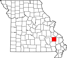 | |
| Villages | ||
| Townships | ||
| CDPs | ||
| Other unincorporated communities | ||
| Abandoned villages | ||