José Aponte de la Torre Airport
| José Aponte de la Torre Airport Aeropuerto José Aponte de la Torre / Aeropuerto internacional de Ceiba | |||||||||||
|---|---|---|---|---|---|---|---|---|---|---|---|
|
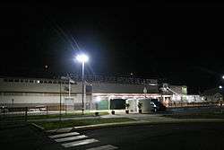
Airport entrance, July 2009 | |||||||||||
| IATA: NRR – ICAO: TJRV – FAA LID: RVR | |||||||||||
| Summary | |||||||||||
| Airport type | Public | ||||||||||
| Owner | Puerto Rico Ports Authority | ||||||||||
| Serves | Ceiba, Puerto Rico | ||||||||||
| Elevation AMSL | 38 ft / 12 m | ||||||||||
| Coordinates | 18°14′43″N 065°38′36″W / 18.24528°N 65.64333°WCoordinates: 18°14′43″N 065°38′36″W / 18.24528°N 65.64333°W | ||||||||||
| Map | |||||||||||
 NRR/TJRV/RVR Location of airport in Puerto Rico | |||||||||||
| Runways | |||||||||||
| |||||||||||
| Statistics | |||||||||||
| |||||||||||
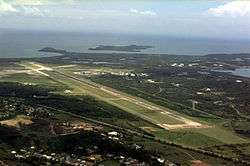
José Aponte de la Torre Airport (IATA: NRR, ICAO: TJRV, FAA LID: RVR) is a public use airport owned by Puerto Rico Ports Authority and located 2 NM (3.7 km; 2.3 mi) from the central business district of Ceiba, a town in Puerto Rico.[1] It is included in the National Plan of Integrated Airport Systems for 2011–2015, which categorized it as a general aviation airport.[2] The airport also offers scheduled passenger service via three commercial airlines to the islands of Vieques and Culebra, Puerto Rico.
The airport opened in November 2008 on the site of the former Roosevelt Roads Naval Station, replacing the Diego Jiménez Torres Airport (IATA: FAJ, ICAO: TJFA, FAA LID: X95) in Fajardo.[3] The airport is being used as a testing site for Google Loon, a project to deliver high-speed internet using hot air balloons.[4]
Facilities
José Aponte de la Torre Airport covers an area of 1,646 acres (666 ha) at an elevation of 38 ft (12 m) above mean sea level. It has one operating runway designated 7/25 with asphalt and concrete surface measuring 11,000 ft × 150 ft (3,353 m × 46 m). There is also a closed runway designated 18/36 which measures 5,800 ft × 100 ft (1,768 m × 30 m).[1] There is a mechanics school located at the airport, Puerto Rico Aviation Maintenance Institute (PRAMI). American Airlines donated an MD-82 to the mechanics school located at the airport.[5] Here are pictures of the American Airlines MD-82, which sits on closed runway 18/36. [6][7][8]
Airlines and destinations
The following airlines offer scheduled passenger service at this airport:
| Airlines | Destinations |
|---|---|
| Air Flamenco | Culebra, Vieques[9] |
| Isla Nena Air | Culebra, Vieques[10] |
| Vieques Air Link | Culebra, Vieques[11] |
Charter
| Airlines | Destinations |
|---|---|
| M&N Aviation | Charter flights[12] |
See also
References
- 1 2 3 FAA Airport Master Record for RVR (Form 5010 PDF). Federal Aviation Administration. Effective April 5, 2012.
- ↑ "2011–2015 NPIAS Report, Appendix A" (PDF). National Plan of Integrated Airport Systems. Federal Aviation Administration. 2010-10-04.
- ↑ "Puerto Rico's newest airport opens on old Navy base". Associated Press via USA Today. November 24, 2008.
- ↑ "El Nuevo Día". www.elnuevodia.com. Retrieved 2016-10-16.
- ↑ https://www.youtube.com/watch?v=K-NlfI4Jsp4
- ↑ http://www.planespotters.net/Aviation_Photos/photo.show?id=305900
- ↑ http://www.planepictures.net/netsearch4.cgi?stype=reg&srng=1&srch=N428AA
- ↑ http://aroundguides.com/21481664/Photos
- ↑ Air Flamenco
- ↑ Isla Nena Air Services, Inc.
- ↑ Vieques Air Link: Schedule
- ↑ M&N Aviation: Services
External links
- Resources for this airport:
- FAA airport information for RVR
- AirNav airport information for TJRV
- FlightAware airport information and live flight tracker
- SkyVector aeronautical chart for TJRV