Jim Wright Farmstead Historic District
|
Wright, Jim, Farmstead Historic District | |
 | |
  | |
| Nearest city | Bald Knob, Arkansas |
|---|---|
| Coordinates | 35°21′14″N 91°37′10″W / 35.35389°N 91.61944°WCoordinates: 35°21′14″N 91°37′10″W / 35.35389°N 91.61944°W |
| Area | less than one acre |
| Architectural style | Bungalow/craftsman |
| MPS | White County MPS |
| NRHP Reference # | 91001284[1] |
| Added to NRHP | September 5, 1991 |
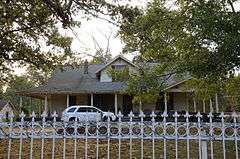
The Jim Wright Farmstead Historic District encompasses a well-preserved early 20th-century farmstead in rural White County, Arkansas. The property is located on the south side of Arkansas Highway 258, east of its junction with Arkansas Highway 323, northwest of Bald Knob. It includes a Craftsman style single-story wood frame farmhouse, with a wraparound porch supported by simple Doric columns, a simple wood-frame garage, and a single-story wood frame house for tenant workers. It also includes remnants of the farmstead's first house and barn, silo, and a cattle dipping vat. This land was homesteaded in 1860 by the parents of Jim Wright, who is credited with construction of most of the farmstead's surviving features, which were built between 1924 and 1940.[2]
The farmstead was listed on the National Register of Historic Places in 1991.[1]
See also
References
- 1 2 National Park Service (2010-07-09). "National Register Information System". National Register of Historic Places. National Park Service.
- ↑ "NRHP nomination for Jim Wright Farmstead Historic District" (PDF). Arkansas Preservation. Retrieved 2016-02-05.
| Topics | |
|---|---|
| Lists by states |
|
| Lists by insular areas | |
| Lists by associated states | |
| Other areas | |
| |