Jalaun
| Jalaun | |
|---|---|
| city | |
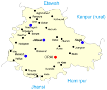
 Jalaun Location in Uttar Pradesh, India | |
| Coordinates: 26°09′N 79°21′E / 26.15°N 79.35°ECoordinates: 26°09′N 79°21′E / 26.15°N 79.35°E | |
| Country |
|
| State | Uttar Pradesh |
| District | Jalaun |
| Elevation | 164 m (538 ft) |
| Population (2011) | |
| • Total | 1,20,000 |
| Languages | |
| • Official | Hindi |
| Time zone | IST (UTC+5:30) |
| PIN | 285123 |
| Telephone code | 05168 XXXXXX |
| Vehicle registration | UP92 X XXXX |
| Website |
www |
Jalaun is a city and a municipal board in Jalaun district in the Indian state of Uttar Pradesh.
The town was formerly the residence of a Maratha governor, but never the headquarters of the district, which are at Orai.
History
In early times Jalaun seems to have been the home of two Rajput clans, the Sengars in the east and the Kachwahas in the west. The village garghgawan was the estate of Bhadaurias clan, the historic monument(GADI)of this clan is still exist in this village.The town of Kalpi on the Yamuna was conquered by the armies of Muhammad of Ghor in 1196. Early in the 14th century the Bundelas occupied the greater part of Jalaun, and even succeeded in holding the fortified post of Kalpi. That important possession was soon recovered by the Delhi Sultanate, and passed under the way of the Mughal Empire. Akbar's governors at Kalpi maintained a nominal authority over the surrounding district, and the Bundela chiefs were in a state of chronic revolt, which culminated in the war of independence under Maharaja Chhatrasal. On the outbreak of his rebellion in 1671 he occupied a large province to the south of the Yamuna. Setting out from this base, and assisted by the Marathas, he conquered the whole of Bundelkhand. On his death in 1732 he bequeathed one-third of his dominions to his Maratha allies, who before long succeeded in annexing the whole of Bundelkhand. Under Maratha rule the country was a prey to constant anarchy and strife. To this period must be traced the origin of the poverty and desolation which are still conspicuous throughout the district.
In 1803 Kalpi was captured by the British. Jalaun State became a British protectorate in 1806. But in 1840, on the death of Nana Gobind Ras without descendants, it was annexed to British India by virtue of the doctrine of lapse.[1] Various interchanges of territory took place, and in 1856 the boundaries of the British district were substantially settled, with an area of 1,477 square miles (3,830 km2).
Jalaun was the scene of much violence during the Revolt of 1857. When the news of the rising at Kanpur reached Kalpi, the men of the 53rd Native Infantry deserted their officers, and in June the Jhansi rebels reached the district, and began their murder of Europeans. It was not until September 1858 that the rebels were finally defeated. In the later 19th century, the district suffered much from the invasive kans grass (Saccharum spontaneum), owing to the spread of which many villages were abandoned and their land thrown out of cultivation. The population of the district was 399,726 in 1901, and the two largest towns were Konch and Kalpi (pop. 10,139 in 1901). The district was traversed by the line of the Indian Midland railway from Jhansi to Kanpur. A small part of it is watered by the Betwa Canal. Grain, oil-seeds, cotton and ghee were exported. According to History the British Jalaun in year 1840 state of the Maratha merger by its territory was taken intax Pargana Orai-Jalaun Aata and Mahoba instructed own its rights under was received it Jalaun District of Jalaun becoming the first phase can be said. there are two types stories about name Jalaun, According to first one in Jalaun territory, there were dense net of forests because in Hindi forests known as 'Wan'and net means 'Jal'. so JALAUN got its name JAlwan. By the time it changed as 'JALAUN'. Second story tells that Jalaun named after a saint 'Jalana'. Jalaun is the city which has its headquarters in Orai. that's why Jalaun is still struggling for basic needs of Railways, Roadways stands, Industrial areas, educational hubs, Good leadership, Employment.
Geography
Jalaun is located at 26°09′N 79°21′E / 26.15°N 79.35°E.[2] It has an average elevation of 144 metres (472 feet).
Demographics
As of 2001 India census,[3] Jalaun had a population of 50,033. Males constitute 53% of the population and females 47%. Jalaun has an average literacy rate of 64%, higher than the national average of 65.38: male literacy is 72%, and female literacy is 55%. In Jalaun, 15% of the population is under 6 years of age.
Main crops
- Wheat
- Green Pea
- Menthol
- Pulse (Tuar/Pigeopea, Urad, Masoor/Lentil, Gram/Chickpea etc.)
References
- ↑ Princely States of India
- ↑ Falling Rain Genomics, Inc - Jalaun
- ↑ "Census of India 2001: Data from the 2001 Census, including cities, villages and towns (Provisional)". Census Commission of India. Archived from the original on 2004-06-16. Retrieved 2008-11-01.
External links
- Jalaun Government Website
 This article incorporates text from a publication now in the public domain: Chisholm, Hugh, ed. (1911). "article name needed". Encyclopædia Britannica (11th ed.). Cambridge University Press.