Agra district
| Agra district आगरा ज़िला آگرہ ضلع | |
|---|---|
| District of Uttar Pradesh | |
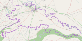
 Location of Agra district in Uttar Pradesh | |
| Country | India |
| State | Uttar Pradesh |
| Administrative division | Agra |
| Headquarters | Agra |
| Tehsils | 6 |
| Government | |
| • Lok Sabha constituencies | Agra, Fatehpur Sikri |
| • Assembly seats | 9 |
| Area | |
| • Total | 4,027 km2 (1,555 sq mi) |
| Population (2011) | |
| • Total | 4,418,797[1] |
| Demographics | |
| • Literacy | 69.44%.[1] |
| Major highways | NH 2 |
| Website | Official website |
Agra District (Hindi: आगरा ज़िला, Urdu: آگرہ ضلع) is one of the 75 districts of Uttar Pradesh state of India, and the historical city of Agra is the district headquarters. Agra district is a part of Agra division.
Geography
Agra district is bounded by Mathura District on the north, Dholpur District of Rajasthan state on the south, Firozabad District on the east and Bharatpur District of Rajasthan State on the west. Area of the district is 4027 km².
Divisions
Agra district comprises 6 tehsils. The tehsils are Etmadpur, Agra, Kiraoli, Kheragarh, Fatehabad and Bah. The headquarters of the district is Agra city. The district consists of 15 blocks, namely Etmadpur, Khandauli, Shamshabad, Fatehabad, Jagner, Kheragarh, Saiyan, Achhnera, Akola, Bichpuri, Fatehpur Sikri, Barauli Ahir, Bah, Pinahat and Jaitpur Kalan.[2]
The division comprises 3 Lok Sabha constituencies namely Jalesar, Firozabad and Agra. There are 9 Vidhan Sabha constituencies in the district. They are Bah, Fatehabad, Etmadpur, Dayal Bagh, Agra Cantonment, Agra East, Agra West, Kheragarh and Fatehpur Sikri.
Demographics
According to the 2011 census Agra district has a population of 4,380,793,[1] roughly equal to the nation of Moldova[3] or the US state of Kentucky.[4] This gives it a ranking of 41st in India (out of a total of 640).[1] The district has a population density of 1,084 inhabitants per square kilometre (2,810/sq mi) .[1] Its population growth rate over the decade 2001-2011 was 21%.[1] Agra has a sex ratio of 859 females for every 1000 males,[1] and a literacy rate of 69.44%.[1]
Languages
Languages spoken include Braj Bhasha, Braj Bhasha is mainly a rural tongue currently, predominant in the nebulous Braj region centred on Mathura and Agra in Uttar Pradesh and Dholpur & Bharatpur in Rajasthan . It is the predominant language in the central stretch of the Ganges-Yamuna Doab.
See also
- Dhar (guerrilla warfare) – combat tactic of Jat of Agra against Mughals
- Jat
- Hinduism
References
- 1 2 3 4 5 6 7 8 "District Census 2011". Census2011.co.in. 2011. Retrieved 2011-09-30.
- ↑ "General Administration". Agra district Official website.
- ↑ US Directorate of Intelligence. "Country Comparison:Population". Retrieved 2011-10-01.
Moldova 4,314,377 July 2011 est.
- ↑ "2010 Resident Population Data". U. S. Census Bureau. Archived from the original on 2010-12-25. Retrieved 2011-09-30.
Kentucky 4,339,367
External links

Coordinates: 27°05′N 77°58′E / 27.083°N 77.967°E