Jalapa, Nueva Segovia
| Jalapa | |
|---|---|
| Municipality | |
 Jalapa Location in Nicaragua | |
| Coordinates: 13°55′N 86°08′W / 13.917°N 86.133°W | |
| Country |
|
| Department | Nueva Segovia Department |
| Government | |
| • Mayor | Orlando Zeledón Sovalbarro |
| Area | |
| • Municipality | 265.21 sq mi (686.88 km2) |
| • Land | 243 sq mi (629 km2) |
| Population (2005) | |
| • Municipality | 85,300 |
| • Density | 320/sq mi (120/km2) |
| • Urban | 24,435 |
Jalapa is a municipality in the Nueva Segovia Department of Nicaragua. It is located in north Nicaragua, close to the Honduras border.
According to the Washington Lieutenant Governor's files, it is a sister city with Port Townsend, Washington which is located on the Puget Sound on the eastern coast of the Olympic Peninsula.
Contra war
Further information: Nicaragua v. United States
Jalapa, which is located on the border of Honduras, was the location of two failed attempts of the CIA funded Contras to overthrow the city and install a provisional government, in late 1982 and December 1983, in which the CIA informed the contras would be immediately recognized by the United States Government.[1]
International relations
Twin towns – Sister cities
Jalapa is twinned with:
 Boulder, Colorado, United States, since 1987[2]
 Jyväskylä, Finland
See also
Notes
- ↑ Gill, Terry D. (1989). Litigation strategy at the International Court a case study of the Nicaragua v United States dispute. Dordrecht. ISBN 0-7923-0332-6. p. 187-191
- ↑ "Boulder Sister City Program". City of Boulder, Colorado. Retrieved September 9, 2011.
Coordinates: 13°55′N 86°08′W / 13.917°N 86.133°W
Capital: Ocotal | ||
| Municipalities | 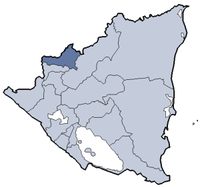 | |
This article is issued from Wikipedia - version of the 7/7/2016. The text is available under the Creative Commons Attribution/Share Alike but additional terms may apply for the media files.