Jackson Township, Putnam County, Ohio
| Jackson Township, Putnam County, Ohio | |
|---|---|
| Township | |
|
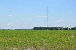
Scene along U.S. Route 224 southwest of Kalida | |
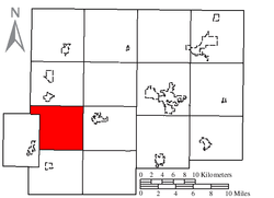 Location of Jackson Township in Putnam County | |
| Coordinates: 40°58′15″N 84°15′37″W / 40.97083°N 84.26028°WCoordinates: 40°58′15″N 84°15′37″W / 40.97083°N 84.26028°W | |
| Country | United States |
| State | Ohio |
| County | Putnam |
| Area | |
| • Total | 25.8 sq mi (66.9 km2) |
| • Land | 25.8 sq mi (66.9 km2) |
| • Water | 0.0 sq mi (0.0 km2) |
| Elevation[1] | 728 ft (222 m) |
| Population (2000) | |
| • Total | 939 |
| • Density | 36.4/sq mi (14.0/km2) |
| Time zone | Eastern (EST) (UTC-5) |
| • Summer (DST) | EDT (UTC-4) |
| FIPS code | 39-38024[2] |
| GNIS feature ID | 1086859[1] |
Jackson Township is one of the fifteen townships of Putnam County, Ohio, United States. The 2000 census found 939 people in the township.[3]
Geography
Located in the western part of the county, it borders the following townships:
- Perry Township - north
- Greensburg Township - northeast corner
- Union Township - east
- Sugar Creek Township - southeast corner
- Jennings Township - south
- Monterey Township - southwest
- Washington Township, Paulding County - northwest
No municipalities are located in Jackson Township.
Name and history
Jackson Township was organized in the 1830s, but the exact date is unknown since records were lost.[4] It is one of thirty-seven Jackson Townships statewide.[5]
Government
The township is governed by a three-member board of trustees, who are elected in November of odd-numbered years to a four-year term beginning on the following January 1. Two are elected in the year after the presidential election and one is elected in the year before it. There is also an elected township fiscal officer,[6] who serves a four-year term beginning on April 1 of the year after the election, which is held in November of the year before the presidential election. Vacancies in the fiscal officership or on the board of trustees are filled by the remaining trustees.
References
- 1 2 "US Board on Geographic Names". United States Geological Survey. 2007-10-25. Retrieved 2008-01-31.
- ↑ "American FactFinder". United States Census Bureau. Archived from the original on September 11, 2013. Retrieved 2008-01-31.
- ↑ Putnam County, Ohio — Population by Places Estimates Ohio State University, 2007. Accessed 15 May 2007.
- ↑ Kinder, George D. (1915). History of Putnam County, Ohio : its peoples, industries, and institutions. B.F. Bowen. p. 120.
- ↑ "Detailed map of Ohio" (PDF). United States Census Bureau. 2000. Retrieved 2007-02-16.
- ↑ §503.24, §505.01, and §507.01 of the Ohio Revised Code. Accessed 4/30/2009.
External links
Municipalities and communities of Putnam County, Ohio, United States | ||
|---|---|---|
| Villages |  | |
| Townships | ||
| CDP | ||
| Unincorporated communities | ||
| Ghost towns | ||