Ivydale, Clay County, West Virginia
| Ivydale, West Virginia | |
|---|---|
| Unincorporated community | |
 Ivydale | |
| Coordinates: 38°32′08″N 81°02′05″W / 38.53556°N 81.03472°WCoordinates: 38°32′08″N 81°02′05″W / 38.53556°N 81.03472°W | |
| Country | United States |
| State | West Virginia |
| County | Clay |
| Elevation | 761 ft (232 m) |
| Time zone | Eastern (EST) (UTC-5) |
| • Summer (DST) | EDT (UTC-4) |
| ZIP code | 25113 |
| Area code(s) | 304 & 681 |
| GNIS feature ID | 1554789[1] |
Ivydale is an unincorporated community in Clay County, West Virginia, United States. Ivydale is located on the Elk River, 6 miles (9.7 km) northeast of Clay. Ivydale has a post office with ZIP code 25113.[2]
References
Municipalities and communities of Clay County, West Virginia, United States | ||
|---|---|---|
| Town | 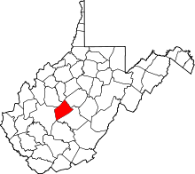 | |
| Unincorporated communities |
| |
| Footnotes | ‡This populated place also has portions in an adjacent county or counties | |
This article is issued from Wikipedia - version of the 9/3/2016. The text is available under the Creative Commons Attribution/Share Alike but additional terms may apply for the media files.