Iron Gates
The Iron Gates (Romanian: Porțile de Fier, Serbian: Đerdapska klisura, German: Eisernes Tor) is a gorge on the Danube River. It forms part of the boundary between Serbia and Romania. In the broad sense it encompasses a route of 134 km (83 mi); in the narrow sense it only encompasses the last barrier on this route, just beyond the Romanian city of Orșova, that contains two hydroelectric dams, with two power stations, Iron Gate I Hydroelectric Power Station and Iron Gate II Hydroelectric Power Station.
The gorge lies between Romania to the north and Serbia to the south. At this point, the river separates the southern Carpathian Mountains from the northwestern foothills of the Balkan Mountains. The Romanian side of the gorge constitutes the Iron Gates natural park, whereas the Serbian part constitutes the Đerdap national park.
Names
In English, the gorge is known as Iron Gates or Iron Gate. An 1853 article about the Danube in The Times of London referred to it as "the Iron Gate, or the Gate of Trajan."[1]
In languages of the region including Romanian, Hungarian, Polish, Slovak, Czech, German and Bulgarian, names literally meaning "Iron Gates" are used to name the entire range of gorges. These names are Romanian: Porțile de Fier (pronounced [ˈport͡sile de ˈfjer], Hungarian: Vaskapu, Slovak: Železné vráta, Polish: Żelazné Bramy, German: Eisernes Tor, and Bulgarian: Железни врата Železni vrata"). An alternative Romanian name for the last part of the route is Defileul Dunării, literally "Danube Gorge".
In Serbian, the gorge is known as Đerdap (Ђердап; [d͡ʑě̞rdaːp]), with the last part named Đerdapska klisura (Ђердапска клисура; [d͡ʑě̞rdaːpskaː klǐsura]) from the Byzantine Greek Κλεισούρα (kleisoura), "enclosure" or "pass."
Gorges

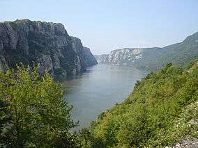
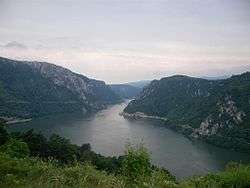
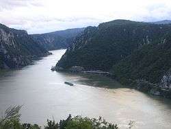
The first narrowing of the Danube lies beyond the Romanian isle of Moldova Veche and is known as the Golubac gorge. It is 14.5 km long and 230 m (755 ft) wide at the narrowest point. At its head, there is a medieval fort at Golubac, on the Serbian bank. Through the valley of Ljupovska lies the second gorge, Gospodjin Vir, which is 15 km long and narrows to 220 m (722 ft). The cliffs scale to 500 m and are the most difficult to reach here from land. The broader Donji Milanovac forms the connection with the Great and the Small Kazan gorge, which have a combined length of 19 km (12 mi). The Orșova valley is the last broad section before the river reaches the plains of Wallachia at the last gorge, the Sip gorge.

The Great Kazan (kazan meaning "cauldron" or "reservoir") is the most famous and the most narrow gorge of the whole route: the river here narrows to 150 m and reaches a depth of up to 53 m (174 ft). East of this site the Roman emperor Trajan had built the legendary bridge erected by Apollodorus of Damascus. Construction of the bridge ran from 103 through 105, preceding Trajan's final conquest of Dacia. On the right (Serbian) bank a Roman plaque commemorates him. On the Romanian bank, at the Small Kazan, the likeness of Trajan's Dacian opponent Decebalus was carved in rock from 1994 through 2004.
Significantly older discoveries have been found in the geographically less spectacular gorge of Gospodjin Vir: in the 1960s the archaeological site Lepenski Vir was unearthed, the most important in all of southeastern Europe. The sandstone statues dated to the early neolithic era are particularly splendid. Together with many other findings in the Iron Gates gorges area, they indicate that the region has been inhabited for a very long time.
Channel
The riverbed rocks and the associated rapids made the gorge valley an infamous passage for shipping. In German, the passage is still known as the Kataraktenstrecke, even though the cataracts are gone. Near the actual "Iron Gates" strait the Prigrada rock was the most important obstacle until 1896: the river widened considerably here and the water level was consequently low. Upstream, the Greben rock near the "Kazan" gorge was notorious.
In 1831 a plan had already been drafted to make the passage navigable, at the initiative of the Hungarian politician István Széchenyi. Finally Gábor Baross, Hungary's "Iron Minister", succeeded in financing this project.
In 1890, near the city of Orsova (in Hungarian; Ursa in Romanian) being the last border town of Hungary, rocks were cleared by explosion over a 2 km (1.2 mi) stretch in order to create an 80 m (262 ft) wide and 3 m (10 ft) deep channel. A spur of the Greben Mountains was removed across a length of over 2 km (1.2 mi). Here, a depth of 2 m (7 ft) sufficed. On 17 September 1896, the 3.2km long Sip Channel thus created (named after the Serbian village on the right bank) was inaugurated by the Austro-Hungarian emperor Franz Joseph, the Romanian king Carol I, and the Serbian king Alexander Obrenovich.
The results of these efforts were slightly disappointing. The currents in the Sip Channel were so strong at 15kts (8m/s) that, until 1973, ships had to be dragged upstream along the canal by locomotive. The Iron Gates thus remained an obstacle of note.
Dams

The construction of the joint Romanian-Yugoslavian mega project commenced in 1964. In 1972 the Iron Gate I Dam was opened, followed by Iron Gate II Dam, in 1984, along with two hydroelectric power stations,two sluices and navigation locks for shipping.
The construction of these dams gave the valley of the Danube below Belgrade the nature of a reservoir, and additionally caused a 35 m rise in the water level of the river near the dam. The old Orșova, the Danube island of Ada Kaleh (below) and at least five other villages, totaling a population of 17,000, had to make way. People were relocated and the settlements have been lost forever to the Danube.
The dam's construction had a major impact on the local fauna and flora as well—for example, the spawning routes of several species of sturgeon were permanently interrupted.
The flora and fauna, as well as the geomorphological, archaeological and cultural historical artifacts of the Iron Gates have been under protection of both nations since the construction of the dam. In Serbia this was done with the Đerdap National Park (since 1974, 636.08 km2 (245.59 sq mi)) and in Romania by the Porțile de Fier National Park (since 2001, 1,156.55 km2 (446.55 sq mi)).
Ada Kaleh

The isle of Ada Kaleh is probably the most evocative victim of the Đerdap dam's construction. A Turkish exclave, it had a mosque and a thousand twisting alleys, and was known as a free port and smuggler's nest. Many other ethnic groups lived there beside Turks.
The island was about 3 km (1.9 mi) downstream from Orșova and measured 1.7 by 0.4-0.5 km. It was walled; the Austrians built a fort there in 1669 to defend it from the Turks, and that fort would remain a bone of contention for the two empires. In 1699 the island came under Turkish control, from 1716 to 1718 it was Austrian, after a four-month siege in 1738 it was Turkish again, followed by the Austrians reconquering it in 1789, only to have to yield it to the Turks in the following peace treaty.

Thereafter, the island lost its military importance. The 1878 Congress of Berlin forced the Ottoman Empire to retreat far into the south, but the island remained the property of the Turkish sultan, allegedly because it was forgotten to be mentioned in the treaty. The inhabitants enjoyed exemption from taxes and customs and were not conscripted. In 1923, when the Ottoman monarchy had disappeared, the island was given to Romania in the Treaty of Lausanne
The Ada Kaleh mosque dated from 1903 and was built on the site of an earlier Franciscan monastery. The mosque's carpet, a gift from the Turkish sultan Abdülhamid II, has been located in the Constanța mosque since 1965.
Most Ada Kaleh inhabitants emigrated to Turkey after the evacuation of the island. A smaller part went to Northern Dobruja, another Romanian territory with a Turkish minority.
Cultural references and uses
Literature
- The pre-historic settings of the Earth's Children book series focuses in on difficulties traveling through or around the Iron Gates in both the second ("The Valley of Horses") and fourth ("The Plains of Passage") novels during scene sequences detailing travel adventures whilst the protagonists navigate between the upper and lower Danube valleys.
- The book Between the Woods and the Water by Patrick Leigh Fermor describes a night on the now submerged island Ada Kaleh and a trip by ferry through the Iron Gates, in August, 1934.
Film
- The 2003 film Donau, Duna, Dunaj, Dunav, Dunarea contains several minutes of film of the Iron Gates.
Music
- The Iron Gates are mentioned in the second verse of the Zvonko Bogdan song Rastao sam pored Dunava.
- The folk song Jugoslavijo by Milutin Popović, commonly called Od Vardara pa do Triglava, includes a mention of the Iron Gates in the beginning.
Gallery


 Ponicova cave
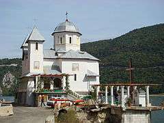 Mraconia Monastery
.jpg)

See also
- Commissions of the Danube River
- Danube River Conference of 1948
- Defile (geography)
- Energy in Romania
References
Further reading
- Bonsall, Clive; Lennon, Rosemary; McSweeney, Kathleen; Stewart, Catriona; Harkness, Douglas; Boronean, Vasile; Bartosiewicz, László; Payton, Robert; Chapman, John (1997). "Mesolithic and Early Neolithic in the Iron Gates: A Paiaeodietary Perspective". Journal of European Archaeology. 5 (1): 50–92. doi:10.1179/096576697800703575.
- Bonsall, C; Cook, G T; Hedges, R E M; Higham, T F G; Pickard, C; Radovanović, I (2004). "Radiocarbon and stable isotope evidence of dietary change from the Mesolithic to the Middle Ages in the iron gates: New results from Lepenski Vir". Radiocarbon. 46 (1): 293–300.
- Teodoru, Cristian; Wehrli, Bernhard (2005). "Retention of Sediments and Nutrients in the Iron Gate I Reservoir on the Danube River". Biogeochemistry. 76 (3): 539–65. doi:10.1007/s10533-005-0230-6.
- Micić, Vesna; Kruge, Michael; Körner, Petra; Bujalski, Nicole; Hofmann, Thilo (2010). "Organic geochemistry of Danube River sediments from Pančevo (Serbia) to the Iron Gate dam (Serbia–Romania)". Organic Geochemistry. 41 (9): 971–4. doi:10.1016/j.orggeochem.2010.05.008.
- Roksandic, Mirjana; Djurić, Marija; Rakočević, Zoran; Seguin, Kimberly (2006). "Interpersonal violence at Lepenski Vir Mesolithic/Neolithic complex of the Iron Gates Gorge (Serbia-Romania)". American Journal of Physical Anthropology. 129 (3): 339–48. doi:10.1002/ajpa.20286. PMID 16323188.
- Boric, Dusan; Miracle, Preston (2004). "Mesolithic and Neolithic (Dis)Continuities in the Danube Gorges: New Ams Dates from Padina and Hajducka Vodenica (Serbia)". Oxford Journal of Archaeology. 23 (4): 341–71. doi:10.1111/j.1468-0092.2004.00215.x.
- Bonsall, Clive (2008). "The Mesolithic of the Iron Gates". In Bailey, Geoff; Spikins, Penny. Mesolithic Europe. Cambridge: Cambridge University Press. pp. 238–79. ISBN 978-0-521-85503-7.
External links
| Wikimedia Commons has media related to Iron Gate (Danube). |
- (Romanian) Porțile de Fier National Park
- (Serbian) Lepenski Vir
- (German) Ada Kaleh, die Inselfestung, also the source of the Ada Kaleh section in this article
Coordinates: 44°40′16″N 22°31′47″E / 44.67111°N 22.52972°E
Seven Serbian Wonders of Construction
| ||
Seven Serbian Wonders of Nature
| ||