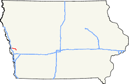
Iowa Highway 127
| ||||
|---|---|---|---|---|
 | ||||
| Route information | ||||
| Maintained by Iowa DOT | ||||
| Length: | 15.985 mi[1] (25.725 km) | |||
| Major junctions | ||||
| West end: |
| |||
|
| ||||
| East end: |
| |||
| Location | ||||
| Counties: | Harrison | |||
| Highway system | ||||
| ||||

Iowa Highway 127 is an east–west highway in western Iowa. It has a length of 16 miles (26 km). It lies entirely in Harrison County. Iowa Highway 127's western terminus is at Interstate 29 near Mondamin, while its eastern terminus is in Logan at U.S. Highway 30.
Route description
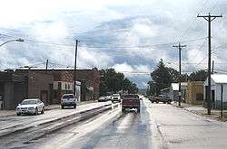
Iowa Highway 127 begins at an interchange with Interstate 29 (I-29) west of Mondamin, traveling east along a two-lane highway. 4⁄5 mile (1.3 km) east of I-29, it meets Harrison County Road K45 (CR K45), which is a former alignment of U.S. Route 75. Three miles east of Mondamin, it meets the southern end of Iowa Highway 183, which is part of the Loess Hills Scenic Byway (LHSB). The LHSB follows Iowa 127 for 1 1⁄2 miles (2.4 km) before Iowa 127 turns to the east and the LHSB continues south along CR L20. The route travels east for 6 miles (9.7 km),[2] passing through Magnolia, after which it turns to the south towards Logan. The designation ends at U.S. Route 30 in downtown Logan.[3]
History
Iowa Highway 127 originally went traveled between U.S. Route 75 west of Magnolia, where it now meets Harrison CR L20, and U.S. Route 30 in Logan. This intersection is now where it meets Harrison County Road L20. In 1968, upon completion of Interstate 29 west of Mondamin, US 75 was relocated onto I-29 and Iowa 127 was extended west to the interstate.[4]
Major intersections
The entire route is in Harrison County.
| Location | mi[1] | km | Destinations | Notes | |
|---|---|---|---|---|---|
| Mondamin | 0.000 | 0.000 | |||
| 4.247 | 6.835 | ||||
| Magnolia | 5.662 | 9.112 | Former Iowa 183 | ||
| Logan | 15.985 | 25.725 | |||
| 1.000 mi = 1.609 km; 1.000 km = 0.621 mi | |||||
References
- 1 2 "2009 Volume of Traffic on the Primary Road System of Iowa" (PDF). Iowa Department of Transportation. January 1, 2009. Retrieved July 31, 2010.
- ↑ Highway and Transportation Map of Harrison County, Iowa (PDF) (Map). Iowa Department of Transportation. January 1, 2009. Retrieved July 31, 2010.
- ↑ Iowa Department of Transportation (2010). Iowa State Highway Map (PDF) (Map). Ames: Iowa Department of Transportation. Retrieved July 31, 2010.
- ↑ Iowa State Highway Commission (1969). Iowa State Highway Map (PDF) (Map). Ames: Iowa State Highway Commission. Retrieved July 31, 2010.