Inishturk
| Native name: <span class="nickname" ">Inis Toirc | |
|---|---|
 North coast of Inishturk | |
 Inishturk | |
| Geography | |
| Location | Atlantic Ocean |
| Coordinates | 53°42′05″N 10°06′30″W / 53.7014°N 10.1083°WCoordinates: 53°42′05″N 10°06′30″W / 53.7014°N 10.1083°W |
| Area | 0.24 km2 (0.093 sq mi) |
| Highest elevation | 189.3 m (621.1 ft)[1] |
| Administration | |
| Province | Connacht |
| County | Mayo |
| Demographics | |
| Population | 58 (2014) |
| Pop. density | 221 /km2 (572 /sq mi) |
| Ethnic groups | Irish |
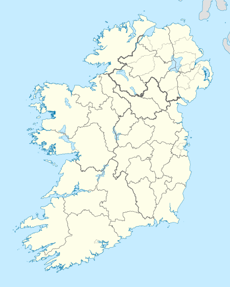
Inishturk (Inis Toirc in Irish, meaning Wild Boar Island) is an inhabited island of County Mayo, in Ireland.[2]
Geography

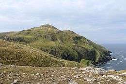
The island lies about 15 km (9 mi) off the coast; its highest point reaches 189.3 m (621.1 ft) above sea level.[1] Between Inisturk and Clare Island lies Caher Island. It has a permanent population of 58 people.[3] There are two main settlements, both on the more sheltered eastern end of the island, Ballyheer and Garranty. Bellavaun and Craggy are abandoned settlements. The British built a Martello tower on the western coast during the Napoleonic Wars. Inisturk has the highest per capita donation rate towards the RNLI in the whole of Ireland.
History
Inishturk has been inhabited on and off since 4,000 BCE and has been inhabited permanently since at least 1700.[4] Some of the more recent inhabitants are descended from evacuees from Inishark to the southwest. The social club Mountain Common is situated on the hill that separates the two settlements.
Recent history
In 1993 Inishturk Community centre was opened, this community centre doubles as a library and a pub.
In June 2014 the ESB commissioned three new Broadcrown BCP 110-50 100kVA diesel generators to supply electricity to the island[5] The ESB have operated a diesel power station on the island since the 1980s[6]
Inishturk gained international attention in 2016 after a number of websites claimed that the island would welcome any American "refugees" fleeing a potential Donald Trump presidency.[7][8][9] These claims were used as one example of the type of "fake news" that arose during the 2016 US presidential election campaign.[10] As of November 2016, no changes to inward migration have been reported.
Demographics
The table below reports data on Inisturk's population taken from Discover the Islands of Ireland (Alex Ritsema, Collins Press, 1999) and the Census of Ireland.
| Historical population | |||||||||||||||||||||||||||||||||||||||||||||||||||||||||||||||||||||||||||||||||||
|---|---|---|---|---|---|---|---|---|---|---|---|---|---|---|---|---|---|---|---|---|---|---|---|---|---|---|---|---|---|---|---|---|---|---|---|---|---|---|---|---|---|---|---|---|---|---|---|---|---|---|---|---|---|---|---|---|---|---|---|---|---|---|---|---|---|---|---|---|---|---|---|---|---|---|---|---|---|---|---|---|---|---|---|
|
|
| |||||||||||||||||||||||||||||||||||||||||||||||||||||||||||||||||||||||||||||||||
| Source: Central Statistics Office. "CNA17: Population by Off Shore Island, Sex and Year". CSO.ie. Retrieved October 12, 2016. | |||||||||||||||||||||||||||||||||||||||||||||||||||||||||||||||||||||||||||||||||||
Transport
Prior to 1997 there was no scheduled ferry service and people traveled to and from the islands using local fishing boats. Since then a ferry service operates from Roonagh Quay, Louisburgh, County Mayo.[11] The pier was constructed during the 1980s by the Irish government, around this time the roads on the island were paved.[12]
Gallery
 Inisturk and Caher island
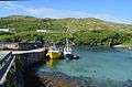 Inishturk pier
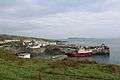 Harbour with Caher Island in background
 Community centre
 Freshwater lake
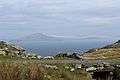 Clare Island as seen from Inishturk
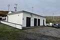 Power station
See also
References
- 1 2 "Inisturk". MountainViews. Ordnance Survey Ireland. Retrieved February 23, 2015.
- ↑ Sometimes the island's name is reported as Inisturk, as for instance by Google Maps
- ↑ http://www.breakingnews.ie/ireland/no-christmas-medical-cover-on-island-of-inishturk-655775.html
- ↑ Mayo Walks - Inishturk
- ↑ BC Inishturk case study
- ↑ New hope for Inishturk
- ↑ http://www.theatlantic.com/video/index/491813/the-tiny-irish-island-that-will-welcome-american-refugees/
- ↑ Huffington Post - Looking to escape Donald Trump
- ↑ Remote Irish island seeks American fleeing Donald Trump presidency
- ↑ "Fake news is big business - and may have handed Trump the election". The Business Post. 20 November 2016. (subscription required (help)).
- ↑ islander committed to her community
- ↑ Winter Inishturk
External links
-
 Media related to Inishturk at Wikimedia Commons
 - Podcast series on Mayo's Heritage, including a heritage Tour of Inishturk
- Mayo News - Inishturk islander committed to her community
- Island life Inishbofin Inishturk