Indiana State Road 104
| ||||
|---|---|---|---|---|
 | ||||
| Route information | ||||
| Maintained by INDOT | ||||
| Length: | 9.519 mi[1] (15.319 km) | |||
| Existed: | 1940s – present | |||
| Major junctions | ||||
| West end: |
| |||
| East end: |
| |||
| Location | ||||
| Counties: | LaPorte, St. Joseph | |||
| Highway system | ||||
| ||||

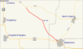
State Road 104 (SR 104) is a part of the Indiana State Road that runs through LaPorte and St. Joseph counties in the US state of Indiana. The 9.51 miles (15.30 km) of SR 104 that lie within Indiana serve as a minor highway. None of the highway is listed on the National Highway System. Most of the route is an rural two-lane highway. The highway passes through residential properties and farmland.
Route description
SR 104 begins in LaPorte County at an all-way stop with SR 4, a few miles southeast of the town of LaPorte. The route heads southeast towards Walkerton, as a two-lane rural highway, passing through farmland with some houses. The road crosses the Canadian National Railway, near Stillwell. Afterwards the highway crosses the Kankakee River. The route enters Walkerton and passes through residential. The highway crosses the CSX Railroad track, soon after the tracks the highway ends at U.S. Route 6 (US 6). At US 6 the path that SR 104 was on crosses US 6 and becomes a city street serving the Walkerton Industrial Park.[2][3][4]
No segment of State Road 104 in Indiana that is included in the National Highway System (NHS).[5] The NHS is a network of highways that are identified as being most important for the economy, mobility and defense of the nation.[6] The highway is maintained by the Indiana Department of Transportation (INDOT) like all other state roads in the state. The department tracks the traffic volumes along all state roads as a part of its maintenance responsibilities using a metric called average annual daily traffic (AADT). This measurement is a calculation of the traffic level along a segment of roadway for any average day of the year. In 2010, INDOT figured that lowest traffic levels were 980 vehicles and 100 commercial vehicles used the highway daily from the western terminus to the Kankakee River. The peak traffic volumes were 2,190 vehicles and 150 commercial vehicles AADT along the section of SR 104 between the Kankakee River and the LaPorte–St. Joseph county line.[7]
Major intersections
| County | Location | mi[1] | km | Destinations | Notes |
|---|---|---|---|---|---|
| LaPorte | Pleasant Township | 0.000 | 0.000 | Western terminus of SR 104 | |
| St. Joseph | Lincoln Township | 9.519 | 15.319 | Eastern terminus of SR 104 | |
| 1.000 mi = 1.609 km; 1.000 km = 0.621 mi | |||||
References
- 1 2 Indiana Department of Transportation (July 2015). Reference Post Book (PDF). Indianapolis: Indiana Department of Transportation. Retrieved September 17, 2016.
- ↑ Indiana Department of Transportation (August 23, 2011). Indiana Railroad Map (PDF) (Map). 1:633,600. Indianapolis: Indiana Department of Transportation. Retrieved December 3, 2012.
- ↑ Google (December 3, 2012). "Overview of State Road 104" (Map). Google Maps. Google. Retrieved December 3, 2012.
- ↑ Indiana Department of Transportation (2012). Indiana Transportation Map (PDF) (Map) (2011–12 ed.). 1:550,000. Indianapolis: Indiana Department of Transportation. § B6. OCLC 765461296. Retrieved December 3, 2012.
- ↑ Federal Highway Administration (December 2003). National Highway System: Indiana (PDF) (Map). Scale not given. Washington, DC: Federal Highway Administration. Retrieved December 3, 2012.
- ↑ Natzke, Stefan; Neathery, Mike; Adderly, Kevin (September 26, 2012). "What is the National Highway System?". National Highway System. Federal Highway Administration. Retrieved December 3, 2012.
- ↑ Indiana Department of Transportation (2010). "Indiana Traffic Counts". Indianapolis: Indiana Department of Transportation. Retrieved December 3, 2012.