Interstate 15 in Nevada
| ||||
|---|---|---|---|---|
_map.svg.png) | ||||
| Route information | ||||
| Maintained by NDOT | ||||
| Length: | 123.776 mi[1] (199.198 km) | |||
| Existed: | June 29, 1956 – present | |||
| Major junctions | ||||
| South end: |
| |||
|
| ||||
| North end: |
| |||
| Highway system | ||||
| ||||
.svg.png)
Interstate 15 (I-15) is an Interstate Highway in the U.S. state of Nevada that begins in Primm, continues through Las Vegas and it crosses the border with Arizona in Mesquite. The freeway runs entirely in Clark County. Many motorists use I-15 to visit Las Vegas, as it is the only primary Interstate Highway in the city. The highway was built along the corridor of the older U.S. Route 91 (US 91) and Arrowhead Trail, eventually replacing both of these designations.
Route description
.jpg)
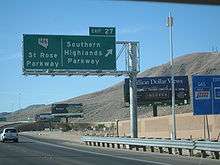
Motorists in California leave the mountainous Mojave Desert and begin a long descent through Ivanpah Valley and Ivanpah Dry Lake. I-15 crosses the Nevada state line at the first exit, Primm. Once I-15 leaves Primm, the route travels north through the desert with few services. The highway then enters the Las Vegas urban area upon passing the State Route 146 (SR 146, Saint Rose Parkway) interchange. Quickly thereafter, the Interstate meets I-215 at the Southern Beltway Interchange, which provides access to Henderson and McCarran International Airport. Originally, this interchange was termed Son of Spaghetti Bowl by the Las Vegas Review-Journal when the interchange was built.
_in_Las_Vegas%2C_Nevada.jpg)
I-15 travels along the west side of the Las Vegas Strip corridor and just west of downtown Las Vegas just before its junction with I-515 and US 95 (the "Spaghetti Bowl" interchange). Then the interstate enters North Las Vegas and continues to run roughly parallel to Las Vegas Boulevard (old US 91) as it leaves the Las Vegas urban limits near the northern junction with the Clark County 215 beltway.[2]
Once I-15 leaves North Las Vegas, the freeway travels northeast and crosses the Muddy River at Glendale and then climbs up onto the Mormon Mesa. At Mesquite, the freeway then crosses the Arizona state line and cuts through the extreme northwestern corner of Arizona through the Virgin River Gorge before entering Utah.
History

Early routes
The general location of the I-15 corridor through Nevada can be traced as far back as the early 1900s. Regular automobile travel through southern Nevada was established by 1914 along the Arrowhead Trail, a road connecting Los Angeles and Salt Lake City.[3] In 1919, the Nevada Legislature amended its newly adopted highway law to add SR 6, which was described as "Commencing at the Arizona line near Mesquite and running southwesterly over what is now known as the Arrow Head [sic] trail through Las Vegas to Jean, Nevada."[4] Two years later, the route was revised to pass through Las Vegas and head "via Jean or Goodsprings to a junction with the California state highway system."[5]
US 91 was later proposed as part of the original 1925 U.S. Highway System plan. As originally proposed, US 91 would have followed SR 6 southwest from Mesquite to downtown Las Vegas, where it would then turn southeast along SR 5 to California via Searchlight.[6] The revised 1926 plan had proposed US 91 follow SR 6 through Las Vegas and Jean to the California state line.[7] Nevada's 1927 official highway map reflects the routing of the final 1926 plan; however, a few maps from the era indicate the original proposal.[8][9]
US 91/SR 6 began at Primm and followed the Los Angeles Highway towards Las Vegas. Within the city limits, it ran along Fifth Street (now Las Vegas Boulevard) through downtown and into North Las Vegas, where it departed from 5th at Main Street. Exiting the Las Vegas area to the northeast, US 91 became the Salt Lake Highway and then headed towards Apex and Glendale. The highway then curved east-northeast before following present-day SR 170 through Riverside and Bunkerville into Mesquite. US 91 was routed through that city on Mesquite Boulevard, Sandhill Boulevard and Fairview Avenue before crossing the Arizona state line. By 1929, the alignment of US 91/SR 6 was graded throughout much of the state, a distance of 129.5 miles (208.4 km).[10]
The route eventually gained two other highway overlaps. US 466 was christened in 1934, and was routed concurrently along US 91 from California to downtown Las Vegas before heading southeast to Hoover Dam (the route was deleted in 1971).[11] Also, in 1936, US 93 was extended from its 1932 southern terminus at Glendale, over US 91 to downtown Las Vegas on its way to Hoover Dam.[12]
Interstate development
A new alignment of US 91 was completed in 1955. This bypassed both Bunkerville and Mesquite to the northwest, along what would become the future path of I-15.[13] The original alignment through Bunkerville is now SR 170.
The passage of the Federal Aid Highway Act of 1956 quickly brought upgrades to the US 91 corridor. The first section of the newly designated I-15 opened by 1960. This stretch extended from the California state line to just north of Sloan.[14] In 1963, the new freeway reached the south end of the Las Vegas Valley at Blue Diamond Road, and more than 20 miles (32 km) south of Glendale was also finished.[15] By 1967, I-15 had been constructed along the entire length of US 91 except through parts of Las Vegas and near Mesquite.[16]
The final sections of I-15 to be completed were in North Las Vegas and near the Arizona state line.[17] Both of these sections were completed in 1974. The US 91 designation, which had remained on its original alignment during the construction of the Interstate, was made redundant by the new freeway and was removed in 1974.[18][19]
Between Las Vegas and the Nevada state line, the Nevada Department of Transportation (NDOT) added callboxes at one-mile (1.6 km) intervals in the mid-2000s, used for motorists who end up with vehicle problems and don't have access to a cell phone. This was done as part of a larger project that expanded this portion of the freeway to three travel lanes in each direction to coordinate with a similar effort in California.
Exit list
The entire route is in Clark County.
| Location | mi[20] | km | Exit | Destinations | Notes | |
|---|---|---|---|---|---|---|
| Primm | 0.00 | 0.00 | — | Continuation into California | ||
| 0.39 | 0.63 | 1 | Primm (Primm Boulevard) | |||
| Jean | 12.63 | 20.33 | 12 | |||
| | 25.52 | 41.07 | 25 | Sloan (Sloan Road) | ||
| Enterprise (unincorporated) | 27 | |||||
| 29 | Starr Avenue | Interchange under construction | ||||
| 30 | Cactus Avenue | |||||
| 31 | Silverado Ranch Boulevard | Southern end of I-15 express lanes | ||||
| 33.55 | 53.99 | 33 | ||||
| 34.85 | 56.09 | 34 | Northbound exit is part of exit 33; southbound exit to CC 215 west is part of exit 36; I-215 exit 12; US 95 detour route to Reno[21] | |||
| Paradise (unincorporated) | 36.39 | 58.56 | 35 | Russell Road (SR 594), Frank Sinatra Drive | Signed as exit 36 southbound; no southbound access to/from or northbound entrance from Frank Sinatra Drive | |
| 37.40 | 60.19 | 36 | Tropicana Avenue (SR 593), Frank Sinatra Drive – UNLV | Signed as exit 37 southbound; no southbound access to/from or northbound entrance from Frank Sinatra Drive | ||
| 38.35 | 61.72 | 38 | Flamingo Road (SR 592 west) | Signed as exits 38A (west) and 38B (east) southbound | ||
| 39.16 | 63.02 | 39 | Spring Mountain Road | |||
| Las Vegas | 40.55 | 65.26 | 40 | Sahara Avenue (SR 589) | Northern end of I-15 express lanes; detour route to US 95 north is via Rancho Drive[21] | |
| 41.75 | 67.19 | 41 | Signed as exits 41A (east) and 41B (west/Grand Central Parkway) northbound; detour route to US 95 north via Rancho Drive on Charleston Boulevard is not advisable due to heavy traffic[21] | |||
| 42.89 | 69.02 | 42 | Southern end of US 93 overlap; I-515 exit 76; no access to US 95 north until March 2017[21] | |||
| 43.47 | 69.96 | 43 | D Street | Northbound exit and southbound entrance; connected by frontage roads to exit 44; detour route to US 95 north is via Rancho Drive[21] | ||
| 43.60 | 70.17 | 44 | Washington Avenue (SR 578 east) | Southbound exit and northbound entrance; connected by frontage roads to exit 43; detour route to US 95 north is via Rancho Drive[21] | ||
| North Las Vegas | 44.72 | 71.97 | 45 | Lake Mead Boulevard (SR 147 east) | ||
| 46.45 | 74.75 | 46 | Cheyenne Avenue (SR 574) | |||
| 48.44 | 77.96 | 48 | Craig Road (SR 573) | |||
| 50.15 | 80.71 | 50 | Lamb Boulevard (SR 610 south) | |||
| 52 | US 95 detour route to Reno[21] | |||||
| 53.65 | 86.34 | 54 | Speedway Boulevard, Hollywood Boulevard | Serves Las Vegas Motor Speedway | ||
| | 58.16 | 93.60 | 58 | |||
| | 64.31 | 103.50 | 64 | Northern end of US 93 overlap | ||
| | 75.70 | 121.83 | 75 | Valley of Fire, Lake Mead (Valley of Fire Highway) | Serves Moapa River Indian Reservation | |
| | 80.78 | 130.00 | 80 | Ute | ||
| | 84.56 | 136.09 | 84 | Byron | ||
| | 88.71 | 142.76 | 88 | Hidden Valley (Hidden Valley Road) | ||
| | 90.86 | 146.22 | 90 | Southbound exit and northbound entrance are via exit 91 | ||
| | 91.63 | 147.46 | 91 | Glendale, Moapa (Glendale Boulevard, Lewis Ranch Road) | Southbound entrance is via exit 90 | |
| | 93.91 | 151.13 | 93 | |||
| | 100.45 | 161.66 | 100 | Carp, Elgin (Carp–Elgin Road) | ||
| | 112.03 | 180.29 | 112 | |||
| Mesquite | 118 | Lower Flat Top Drive | ||||
| 120.37 | 193.72 | 120 | Falcon Ridge Parkway, Mesquite Boulevard | Former I-15 Bus. north / SR 144 north | ||
| 122.92 | 197.82 | 122 | Pioneer Boulevard, Sandhill Boulevard | Former I-15 Bus. south / SR 144 south | ||
| 123.77 | 199.19 | — | Continuation into Arizona | |||
1.000 mi = 1.609 km; 1.000 km = 0.621 mi
| ||||||
See also
-
 Nevada portal
 -
 U.S. Roads portal
References
- ↑ State Maintained Highways of Nevada: Description and Maps – Quarterly Changes (April, May, June). Nevada Department of Transportation. July 2014. Retrieved November 8, 2014.
- ↑ McCabe, Francis (July 2, 2009). "Interstate 15 Projects Pile Up". Las Vegas Review Journal.
- ↑ "Arrowhead Trail (1914-1924)". State Historic Preservation. Nevada Department of Cultural Affairs. 2008. Retrieved June 7, 2009.
- ↑ Statutes of the State of Nevada Passed at the Twenty-Ninth Session of the Legislature. Carson City, NV: State Printing Office. 1919. pp. 23–24. Retrieved June 2, 2009.
- ↑ Statutes of the State of Nevada Passed at the Thirtieth Session of the Legislature. Carson City, NV: State Printing Office. 1921. pp. 383–384. Retrieved June 2, 2009.
- ↑ Droz, Robert V. (February 24, 2003). "1925 US Highway Plan". U.S. Highways: from US 1 to (US 830). Retrieved June 2, 2009.
- ↑ Droz, Robert V. (February 28, 2005). "US Highways in 1927". U.S. Highways: from US 1 to (US 830). Retrieved June 2, 2009.
- ↑ Highway Map of the State of Nevada (Map). 1 in=25 mi. Nevada Department of Highways. 1927. Retrieved June 3, 2009.
- ↑ Rand McNally Junior Auto Map (Map). Rand McNally and Co. 1927.
- ↑ Highway Map State of Nevada (Map). 1 in=25 mi. Nevada Department of Highways. 1929. Retrieved June 3, 2009.
- ↑ Official Road Map of Nevada (Map). Nevada State Highway Department. 1934. Retrieved June 3, 2009.
- ↑ Official Road Map of the State of Nevada (Map). Nevada Department of Highways. 1939. Retrieved June 3, 2009.
- ↑ Official Highway Map of Nevada (Map). Nevada Department of Highways. 1955. Retrieved June 3, 2009.
- ↑ 1960 Official Highway Map of Nevada (Map). Nevada State Highway Department. 1960. Retrieved June 3, 2009.
- ↑ 1963-1964 Official Highway Map of Nevada (Map). Nevada State Highway Department. 1963. Retrieved June 3, 2009.
- ↑ 1967 Official Highway Map of Nevada (Map). Nevada State Highway Department. 1967. Retrieved June 3, 2009.
- ↑ 1973 Official Highway Map of Nevada (Map). Nevada State Highway Department. 1973. Retrieved June 3, 2009.
- ↑ Droz, Robert V. (October 29, 2008). "North–South Routes - US 1 to US 101". U.S. Highways: from US 1 to (US 830). Retrieved June 3, 2009.
- ↑ 1975 Official Highway Map of Nevada (Map). Nevada State Highway Department. 1975. Retrieved June 3, 2009.
- ↑ Nevada Interchanges & Structures: I-15. Nevada Department of Transportation. January 1998.
- 1 2 3 4 5 6 7 Marroquin, Art (October 31, 2016). "Car-nado cluster avoided as Las Vegas motorists heed closure warnings". Las Vegas Review-Journal. Retrieved November 16, 2016.
External links
| Wikimedia Commons has media related to Interstate 15 in Nevada. |
| Previous state: California |
Nevada | Next state: Arizona |
| ||