Valley of Fire State Park
| Valley of Fire State Park | |
| Nevada State Park | |
 Valley of Fire State Park | |
| Country | United States |
|---|---|
| State | Nevada |
| County | Clark |
| Location | Overton |
| - elevation | 2,464 ft (751 m) [1] |
| - coordinates | 36°26′20″N 114°31′57″W / 36.43889°N 114.53250°WCoordinates: 36°26′20″N 114°31′57″W / 36.43889°N 114.53250°W |
| Area | 42,059 acres (17,021 ha) |
| Founded | 1935 |
| Management | Nevada Division of State Parks |
 Location of Valley of Fire State Park in Nevada | |
| Designated | 1968 |
Nevada Historical Marker | |
| Reference no. | 150 |
Valley of Fire State Park is the oldest state park in Nevada, USA and was designated as a National Natural Landmark in 1968.[2] It covers an area of 42,059 acres (17,021 ha)[3] and was dedicated in 1935. It derives its name from red sandstone formations, the Aztec Sandstone, which formed from great shifting sand dunes during the age of dinosaurs. These features, which are the centerpiece of the park's attractions, often appear to be on fire when reflecting the sun's rays.
Valley of Fire is located 50 miles (80 km) northeast of Las Vegas, at an elevation between 1,320–3,009 feet (402–917 m).[4] It abuts the Lake Mead National Recreation Area on the east at the Virgin River confluence. It lies in a 4 by 6 mi (6.4 by 9.7 km) basin.
Complex uplifting and faulting of the region, followed by extensive erosion, have created the present landscape. The rough floor and jagged walls of the park contain brilliant formations of eroded sandstone and sand dunes more than 150 million years old. Other important rock formations include limestones, shales, and conglomerates.
The site is marked as Nevada Historical Marker #150.
History
Prehistoric users of the Valley of Fire included the Ancient Pueblo Peoples, also known as the Anasazi, who were farmers from the nearby fertile Moapa Valley. Their approximate span of occupation has been dated from 300 BC to 1150 AD. Their visits probably involved hunting, food gathering, and religious ceremonies, although scarcity of water would have limited their stay. Fine examples of rock art (petroglyphs) left by these ancient peoples can be found at several sites within the park.
Climate
The Valley of Fire State Park has a dry and warm climate typical of the Mojave Desert in which it lies. Winters are mild with daytime temperatures ranging from 54 °F (12 °C) to 75 °F (24 °C). and over night lows in the mid 30°F's to mid 40°F's (3-8°C). Storms moving east from the Pacific Ocean occasionally bring rain during winter months. Daily summer highs usually range from 100 °F (38 °C) to 115 °F (46 °C) and on occasion may reach near 120 °F (49 °C). Thunderstorms from the Southwestern Monsoon can produce heavy showers during summer. The average annual precipitation is 6.50" (165.1mm).
| Climate data for Valley of Fire SP, Nevada | |||||||||||||
|---|---|---|---|---|---|---|---|---|---|---|---|---|---|
| Month | Jan | Feb | Mar | Apr | May | Jun | Jul | Aug | Sep | Oct | Nov | Dec | Year |
| Record high °F (°C) | 74 (23) |
87 (31) |
93 (34) |
100 (38) |
111 (44) |
117 (47) |
117 (47) |
115 (46) |
110 (43) |
102 (39) |
87 (31) |
74 (23) |
117 (47) |
| Average high °F (°C) | 58.0 (14.4) |
62.4 (16.9) |
70.5 (21.4) |
79.3 (26.3) |
89.9 (32.2) |
100.0 (37.8) |
105.4 (40.8) |
103.3 (39.6) |
95.8 (35.4) |
81.9 (27.7) |
67.2 (19.6) |
57.0 (13.9) |
81.0 (27.2) |
| Average low °F (°C) | 38.9 (3.8) |
42.9 (6.1) |
48.4 (9.1) |
55.1 (12.8) |
64.8 (18.2) |
74.2 (23.4) |
80.8 (27.1) |
78.8 (26) |
71.0 (21.7) |
58.7 (14.8) |
46.7 (8.2) |
38.3 (3.5) |
58.3 (14.6) |
| Record low °F (°C) | 19 (−7) |
18 (−8) |
29 (−2) |
29 (−2) |
42 (6) |
48 (9) |
60 (16) |
61 (16) |
49 (9) |
38 (3) |
19 (−7) |
12 (−11) |
12 (−11) |
| Average precipitation inches (mm) | 0.83 (21.1) |
1.05 (26.7) |
0.81 (20.6) |
0.24 (6.1) |
0.10 (2.5) |
0.10 (2.5) |
0.62 (15.7) |
0.64 (16.3) |
0.34 (8.6) |
0.52 (13.2) |
0.49 (12.4) |
0.76 (19.3) |
6.50 (165.1) |
| Source: wrcc.dri.edu [5] | |||||||||||||
Valley of Fire Road
.jpg)
Valley of Fire Road is the main road through the park. The 10.5 mi (16.9 km) road connects the east and west entrances of the park. It was designated as a Nevada Scenic Byway on June 30, 1995.[6]
Park features

Although petroglyphs are present throughout the entire park, Mouse's Tank and Atlatl Rock are two areas in particular which have many petroglyphs while being relatively easily accessible. The park also contains three cabins built by the Civilian Conservation Corps. There are facilities for picnicking, camping, and hiking.
Film history
Valley of Fire is a popular location for shooting automobile commercials and other commercial photography. It has provided a setting for the following films and television shows:
- "Viva Las Vegas" starring Elvis Presley (1963 film) had multiple shots filmed in the park during the racing scenes for the movie finale.
- The Professionals with Burt Lancaster, Lee Marvin, and Claudia Cardinale was filmed in 1966. Valley of Fire was one of three locations used in the film. All that remains of the set is a portion of a rock wall of a hacienda.[7]
- The outside Mars scenes from Total Recall, starring Arnold Schwarzenegger, were almost totally shot in Valley of Fire.[8]
- The scenes from planet Veridian III from Star Trek: Generations were filmed here. The Silica Dome is particularly highlighted for Star Trek fans as the site of iconic starship captain James T. Kirk's death and burial.
Gallery
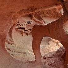 Windstone Arch
 Petroglyphs in Valley of Fire State Park
.jpg) Visitors at Valley of Fire
Visitors at Valley of Fire
See also
- Red Rock Canyon National Conservation Area
- Little Finland and Gold Butte Backcountry Byway
- Moapa River Indian Reservation
References
- ↑ "Valley of Fire State Park". Geographic Names Information System. United States Geological Survey. 1980-12-12. Retrieved 2011-04-02.
- ↑ http://www.nature.nps.gov/nnl/site.cfm?Site=VAFI-NV
- ↑ "Valley of Fire State Park General Management Plan 2010" (PDF). Nevada Division of State Parks. p. 9. Retrieved 2016-08-04.
- ↑ "Valley of Fire State Park General Management Plan 2010" (PDF). Nevada Division of State Parks. p. 30. Retrieved 2016-08-04.
- ↑ WRCC. "1981–2010 MONTHLY NORMALS for Valley of Fire SP, NV". WRCC. Retrieved 2016-11-26.
- ↑ "Nevada's Scenic Byways". Nevada Department of Transportation. Retrieved 2008-09-19.
- ↑ Carlo Gaberscek, Kenny Stier (2014). In Search of Western Movie Sites. Lulu.com. ISBN 978-1312625020.
- ↑ "Scene In Nevada: Total Recall". Nevada Film Office. Retrieved 7 July 2016.
External links
| Wikimedia Commons has media related to Valley of Fire. |
| Wikimedia Commons has media related to Valley of Fire State Park. |
- Valley of Fire State Park Nevada State Parks