Hynes Convention Center (MBTA station)
HYNES CONVENTION CENTER | |||||||||||||||||||||
|---|---|---|---|---|---|---|---|---|---|---|---|---|---|---|---|---|---|---|---|---|---|
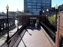
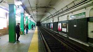 Hynes Convention Center station in January 2014 | |||||||||||||||||||||
| Location |
360 Newbury Street Boston, Massachusetts | ||||||||||||||||||||
| Coordinates | 42°20′52.1″N 71°5′16.18″W / 42.347806°N 71.0878278°WCoordinates: 42°20′52.1″N 71°5′16.18″W / 42.347806°N 71.0878278°W | ||||||||||||||||||||
| Owned by | Massachusetts Bay Transportation Authority | ||||||||||||||||||||
| Line(s) | |||||||||||||||||||||
| Platforms | 2 side platforms | ||||||||||||||||||||
| Tracks | 2 | ||||||||||||||||||||
| Connections |
| ||||||||||||||||||||
| History | |||||||||||||||||||||
| Opened | October 3, 1914[1] | ||||||||||||||||||||
| Rebuilt | 2019 (planned)[2] | ||||||||||||||||||||
| Previous names |
Massachusetts (1914–1965) Auditorium (1965–1990) Hynes Convention Center/ICA (1990–2006)[1] | ||||||||||||||||||||
| Traffic | |||||||||||||||||||||
| Passengers (2013) | 8,946 (weekday average boardings)[3] | ||||||||||||||||||||
| Services | |||||||||||||||||||||
| |||||||||||||||||||||
Hynes Convention Center is an underground light rail station on the MBTA Green Line, located at the intersection of Newbury Street and Massachusetts Avenue at the western end of the Back Bay neighborhood of Boston, Massachusetts. It was opened by the Boston Elevated Railway (BERy) in 1914 as a transfer station between east-west streetcars running in the Boylston Street Subway to the Tremont Street Subway, and north-south streetcars on Massachusetts Avenue. The surface cars were replaced by buses in the mid-20th century; Hynes is still a transfer location to the key route 1 bus and two other MBTA bus routes.
The subway station is not currently wheelchair accessible, although a renovation to the station is planned around 2019 as part of air rights development over the adjacent Massachusetts Turnpike. Like all MBTA bus stops, the surface-level stop is fully accessible.
History
Opening
.jpg)
Construction of the Boylston Street Subway, a westward extension of the 1897-built Tremont Street Subway, began in March 1912.[4] Stations were located to serve Copley Square - a major civic center - and the Massachusetts Avenue thoroughfare. The tunnel including Massachusetts station opened on October 3, 1914.[1]
Just east of the station, the subway curves slightly to the north to parallel the Boston and Albany Railroad (B&A), located below grade in a trench. West of the station, a reverse curve aligned the tunnel with Newbury Street. Massachusetts station was thus located roughly parallel to the B&A tracks and oblique to the Back Bay street grid. Although located below street level, much of the station was actually built in open air due to the adjacent trench.
The main entrance was on Massachusetts Avenue just south of Newbury Street. A secondary entrance to the east end of the station was located on Boylston Street near Dalton Street. A waiting room for passengers transferring to streetcars was located on Massachusetts Avenue next to the main station entrance.[5] However, this small facility soon proved inadequate.
Surface station
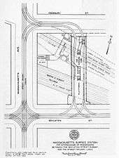
In 1917, the Massachusetts General Court passed legislation allowing the Boston Elevated Railway (BERy) to construct prepayment streetcar transfer areas at existing subway and elevated stations.[6] Soon after, BERy asked the Boston Transit Commission to build such a structure at Massachusetts station.[7] In November 1917, the Public Service Commission approved BERy's plans to construct the transfer station as a bridge between Newbury Street and Boylston Street over the B&A tracks.[8]:6
A reinforced concrete building was built with two tracks and a 27-foot (8.2 m)-wide island platform. Staircases connected it to both subway platforms and the fare mezzanine, with faregates providing access from Newbury and Boylston Streets. Streetcars from either direction on both Massachusetts and Boylston could reach the transfer station, then either loop back to their original or continue in the other three directions.[8]:38 Construction began on February 4, 1918, and demolition of buildings was completed by April 5.[8]:39
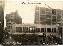
The surface station opened on November 29, 1919.[9] It served as the terminus for four routes, including the 76 Harvard - Mass. Station and 47 Mass. Station - Dudley lines on Massachusetts Avenue plus routes on Boylston Street to Cypress Street Carhouse and Chestnut Hill.[10]
Bustitution
%2C_January_1962.jpg)
When Kenmore opened in 1932, the Boylston Street surface routes were bustituted and cut to Kenmore. The 54 Mass. Station - Bowdoin and 55 Queensbury Street - Copley bus routes, the latter created to cover territory formerly served by the shortened routes, soon were added to the surface station.[10] The 76 route was converted to trackless trolley on September 18, 1949. The 47 route was bustituted on September 12, 1953, followed by the 76 on March 31, 1961.[1]
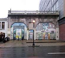
In the early 1960s, the Massachusetts Turnpike Extension was built along the Boston and Albany Railroad Corridor, necessitating a major widening of that right of way. The 47 and 76 were through-routed as route 1 in September 1962 to eliminate looping at the surface station, which was permanently closed on January 21, 1963.[1][9] The portion closer to Boylston Street was demolished soon after. The remaining part, which faces Newbury Street, is used as an MBTA traction power substation, with two large rectifier transformers in the rear.[11] Locally known as "the Slab", the facade is frequently covered in graffiti art and the sidewalk in front is used by buskers. The MBTA has also attempted to lease the space.[10]
A large dedicated bus shelter was built across Massachusetts Avenue for southbound riders in 1963. On November 16, 1964, the newly formed MBTA opened a pedestrian tunnel from the bus shelter to the station's fare lobby.[9] The completion of the Prudential Tower and the adjacent Prudential Center complex in 1965 on what had previous been rail yards increased the number of riders accessing the station from the Boylston Street direction. On April 19, 1965, the MBTA opened a short pedestrian tunnel from the station to a new headhouse on Boylston Street, diagonally across from the Prudential complex.[12]
MBTA era

The station was renamed to Auditorium on February 18, 1965 upon the completion of the War Memorial Auditorium (later renamed Hynes Memorial Auditorium).[9][13] The Auditorium was replaced by the Hynes Convention Center in 1988; two years later, the station was renamed Hynes Convention Center/ICA after the new building and the nearby Institute of Contemporary Art.[1]
The tunnel to the southbound bus shelter was closed due to security concerns in the early 1980s;[14] passengers are supposed to cross at an adjacent crosswalk, but often run across the street directly to or from the subway entrance at midblock. Passengers waiting for northbound buses can wait under the sidewalk canopy of a large building adjacent to the street.
The Boylston Street entrance was closed (except for special events) in the late 1990s.[15] In November 2006, shortly after the ICA relocated from its nearby location on Boylston Street to a new building on the South Boston Waterfront, the station was renamed a third time to Hynes Convention Center.[1]
Planned renovations
The subway station is not currently wheelchair accessible. Design for accessibility improvements was advanced to the 15% design level in March 2013.[16] On September 3, 2014, MassDOT announced the opening of bidding on air rights development over the Mass Pike on Parcel 13 next to the station. As part of the project, the developer was to be required to renovate Hynes Convention Center station with elevators for handicapped accessibility, as well as reopening both the tunnel under Massachusetts Avenue and the disused Boylston Street headhouse.[17][18]
In November 2015, MassDOT approved plans for a development called "The Viola" on the site, with construction to begin in 2019. The developer, Peebles Corporation, will work with the MBTA to design the renovated station, but will not perform the work. Instead, Peebles will provide $30.5 million of the estimated $45.7 million station cost; the MBTA must obtain the remaining funds and organize renovation.[2]
Station layout
The station has two side platforms serving the line's two tracks. The primary entrance to the station is from Massachusetts Avenue, which leads to a fare lobby which connects the west ends of the platforms. A side exit leads from the lobby to Newbury Street.
The secondary entrance from Boylston Street to the east end of the platforms is normally closed; it is opened on Patriot's Day to handle the spectators from the Boston Marathon, as well as for large events like Anime Boston at the convention center.[19] For some of these events, like the 2014 Boston Marathon, it is opened for exiting passengers only.[20] The planned station renovations include permanently reopening the entrance.[17]
| Ground | Street level | Exit or entrance |
| Mezzanine | Concourse | Fare control, crossover between platforms |
| Green Line platforms |
Side platform, doors will open on the right | |
| Outbound | ← Green Line "B" Branch toward Boston College (Kenmore) ← Green Line "C" Branch toward Cleveland Circle (Kenmore) ← Green Line "D" Branch toward Riverside (Kenmore) | |
| Inbound | → Green Line toward North Station, Government Center, or Park Street (Copley) → | |
| Side platform, doors will open on the right | ||
Bus connections
Three MBTA Bus routes stop at the station:
- CT1 Central Square, Cambridge - B.U. Medical Center/Boston Medical Center via M.I.T.
- 1 Harvard/Holyoke Gate - Dudley Station via Massachusetts Avenue & B.U. Medical Center
- 55 Jersey & Queensberry - Copley Square or Park & Tremont Streets via Ipswich Street
The 1 and CT1 stop on Massachusetts Avenue with stops at and across from the station entrance, while the 55 runs on Boylston Street with stops just east of Massachusetts Avenue.[21]
References
- 1 2 3 4 5 6 7 Belcher, Jonathan (26 December 2015). "Changes to Transit Service in the MBTA district 1964-2015" (PDF). NETransit. Retrieved 14 January 2016.
- 1 2 Logan, Tim (3 November 2015). "Housing and hotel plan above Mass. Pike goes forward". Boston Globe. Retrieved 4 November 2015.
- ↑ "Ridership and Service Statistics" (PDF) (14 ed.). Massachusetts Bay Transportation Authority. 2014. Retrieved 30 July 2014.
- ↑ Clarke, Bradley H.; Cummings, O.R. (1997). Tremont Street Subway: A Century of Public Service. Boston Street Railway Association. p. 40. ISBN 0938315048.
- ↑ Boston Transit Commission (1915). Annual report of the Boston Transit Commission, for the year ending June 30, 1915. p. 41 – via Internet Archive.
- ↑ Secretary of the Commonwealth (1917). "Chapter 373: An Act Relative to the Property, Service, and Capitalization of the Boston Elevated Railway". Special Acts and Resolves Passed by the General Court of Massachusetts in the Year 1917. Wright and Potter. pp. 416–417 – via Internet Archive.
- ↑ Boston Transit Commission (1917). Annual report of the Boston Transit Commission, for the year ending June 30, 1917. City of Boston Printing Department. p. 7 – via Internet Archive.
- 1 2 3 Annual report of the Boston Transit Commission, for the year ending June 30, 1918. Boston Transit Commission. 1918 – via Internet Archive.
- 1 2 3 4 A Chronicle of the Boston Transit System. Massachusetts Bay Transportation Authority. 1981. pp. 3–6 – via Internet Archive.
- 1 2 3 Propp, Gil. "Massachusetts Station". Streetcar Tracks. Retrieved 13 January 2016.
- ↑ "Request For Proposals: Air Rights Parcel 13 and Hynes Convention Center Station" (PDF). Massachusetts Department of Transportation. 2 September 2014. pp. 17–20. Retrieved 25 February 2016.
- ↑ "MBTA Station: AUDITORIUM". Boston Globe. April 18, 1965. p. 68 – via Proquest Historical Newspapers. (subscription required (help)).
- ↑ "The City of Boston War Memorial Auditorium". City of Boston. 1965. Retrieved 30 July 2014 – via Internet Archive.
- ↑ Belcher, Jonathan. "Remnants of Abandoned Stations, Tunnels, and Station Entrances found on the MBTA". NETransit. Archived from the original on 29 December 2004.
- ↑ O'Regan, Gerry. "MBTA Green Line". NYCSubway.org. Retrieved 13 January 2016.
- ↑ "Accessibility Upgrades at Symphony, Hynes and Wollaston Stations". Massachusetts Bay Transportation Authority. Archived from the original on 25 January 2014. Retrieved 25 January 2014.
- 1 2 Metzger, Andy (3 September 2014). "State Seeks air rights developer near Hynes station". State House News Service. Archived from the original on 4 September 2014. Retrieved 6 September 2014.
- ↑ "Parcel 13 – Hynes station air rights feasibility study: CAC Presentation March 27, 2014". Boston Redevelopment Authority. 27 March 2014. Retrieved 12 November 2014.
- ↑ "Boylston Street Exit of Hynes Station Open This Weekend for Anime Convention" (Press release). Massachusetts Bay Transportation Authority. 4 April 2012. Retrieved 4 April 2015.
- ↑ Rocheleau, Matt (10 April 2014). "MBTA to close some stations, alter bus routes, while increasing most service for Boston Marathon". Boston Globe. Retrieved 4 April 2015.
- ↑ "Hynes Convention Center Neighborhood Map" (PDF). Massachusetts Bay Transportation Authority. October 2012. Retrieved 3 November 2015.
External links
| Wikimedia Commons has media related to Hynes Convention Center (MBTA station). |
- MBTA - Hynes Convention Center
- Hynes Convention Center station on Google Maps Street View: Massachusetts Avenue entrance, Newbury Street exit and former transfer station, former Boylston Street entrance
| Subway lines (List of stations) |
| |||||||||||
|---|---|---|---|---|---|---|---|---|---|---|---|---|
| Commuter Rail lines (List of stations) |
| |||||||||||
| Bus routes (List of routes) | ||||||||||||
| Other services | ||||||||||||
| Component parts of system lines | ||||||||||||
| Capital projects |
| |||||||||||
| History |
| |||||||||||
| Other | ||||||||||||