Atlantic Avenue Elevated
| Atlantic Avenue Elevated | ||||||||||||||||||||||||||||||||||||||||||||||||||||||||||||||||||||||||||||||||||||||||||||||||||||||||||||||||||||||||||||||||||||||||||||||||||
|---|---|---|---|---|---|---|---|---|---|---|---|---|---|---|---|---|---|---|---|---|---|---|---|---|---|---|---|---|---|---|---|---|---|---|---|---|---|---|---|---|---|---|---|---|---|---|---|---|---|---|---|---|---|---|---|---|---|---|---|---|---|---|---|---|---|---|---|---|---|---|---|---|---|---|---|---|---|---|---|---|---|---|---|---|---|---|---|---|---|---|---|---|---|---|---|---|---|---|---|---|---|---|---|---|---|---|---|---|---|---|---|---|---|---|---|---|---|---|---|---|---|---|---|---|---|---|---|---|---|---|---|---|---|---|---|---|---|---|---|---|---|---|---|---|---|---|
|
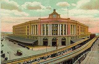
The Atlantic Avenue Elevated outside South Station | ||||||||||||||||||||||||||||||||||||||||||||||||||||||||||||||||||||||||||||||||||||||||||||||||||||||||||||||||||||||||||||||||||||||||||||||||||
| Overview | ||||||||||||||||||||||||||||||||||||||||||||||||||||||||||||||||||||||||||||||||||||||||||||||||||||||||||||||||||||||||||||||||||||||||||||||||||
| System | Boston Elevated Railway | |||||||||||||||||||||||||||||||||||||||||||||||||||||||||||||||||||||||||||||||||||||||||||||||||||||||||||||||||||||||||||||||||||||||||||||||||
| Termini |
North Station Tower D | |||||||||||||||||||||||||||||||||||||||||||||||||||||||||||||||||||||||||||||||||||||||||||||||||||||||||||||||||||||||||||||||||||||||||||||||||
| Stations | 6 | |||||||||||||||||||||||||||||||||||||||||||||||||||||||||||||||||||||||||||||||||||||||||||||||||||||||||||||||||||||||||||||||||||||||||||||||||
| Operation | ||||||||||||||||||||||||||||||||||||||||||||||||||||||||||||||||||||||||||||||||||||||||||||||||||||||||||||||||||||||||||||||||||||||||||||||||||
| Opened | 22 August 1901[1] | |||||||||||||||||||||||||||||||||||||||||||||||||||||||||||||||||||||||||||||||||||||||||||||||||||||||||||||||||||||||||||||||||||||||||||||||||
| Closed | 30 September 1938[1] | |||||||||||||||||||||||||||||||||||||||||||||||||||||||||||||||||||||||||||||||||||||||||||||||||||||||||||||||||||||||||||||||||||||||||||||||||
| Technical | ||||||||||||||||||||||||||||||||||||||||||||||||||||||||||||||||||||||||||||||||||||||||||||||||||||||||||||||||||||||||||||||||||||||||||||||||||
| Number of tracks | 2 | |||||||||||||||||||||||||||||||||||||||||||||||||||||||||||||||||||||||||||||||||||||||||||||||||||||||||||||||||||||||||||||||||||||||||||||||||
| Track gauge | 4 ft 8 1⁄2 in (1,435 mm) | |||||||||||||||||||||||||||||||||||||||||||||||||||||||||||||||||||||||||||||||||||||||||||||||||||||||||||||||||||||||||||||||||||||||||||||||||
| ||||||||||||||||||||||||||||||||||||||||||||||||||||||||||||||||||||||||||||||||||||||||||||||||||||||||||||||||||||||||||||||||||||||||||||||||||
The Atlantic Avenue Elevated was an elevated railway around the east side of downtown Boston, Massachusetts, providing a second route for the Boston Elevated Railway's Main Line Elevated (now the MBTA's Orange Line) around the Washington Street Tunnel. It was in use from 1901 to 1938, and was demolished due to low ridership.[2]
History
The Atlantic Avenue El was conceived as a part of a greater mass transit proposal by the Boston Transit Commission in 1896.[3] After the success of the Tremont Street Subway (now the Green Line) the Commission began looking at options for a unified system that would serve all of downtown Boston and reach out into the growing suburbs. As conceived, there would be two corridors through which elevated trains would run: the Washington Street Tunnel — the heart of today's MBTA Orange Line subway — under Washington Street from a portal at Oak Street to the then-existing subway portal north of Haymarket Square, and an all-elevated line which would run along Atlantic Avenue. At the time, Atlantic Avenue was the heart of the fishing and maritime industries in Boston, and home to ferry terminals. Both the Washington Street Subway and Atlantic Avenue El would service trains from the Main Line El (the elevated section of the old Orange Line, now demolished).
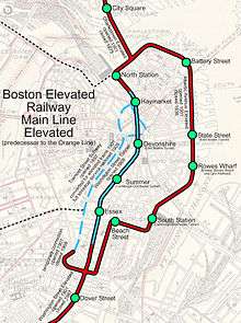
When the Atlantic Avenue El first opened–shortly after the Main Line itself–in August 1901,[1] the Main Line went through the Tremont Street Subway, changing between elevated and subway at the Pleasant Street Incline (in the south) and the Canal Street Incline (in the north). The low-level trolley platforms were altered with temporary high-level platforms to allow elevated trains to unload passengers. Where the original Washington Street Elevated (the south part of the Main Line) turned west from Washington Street onto Castle Street (now Herald Street), it had a full three-way junction (Tower D) with the Atlantic Avenue El, which began by heading east between Motte Street (also part of Herald Street) and the New York, New Haven and Hartford Railroad's approach tracks for South Station.
The El turned north after a block onto Harrison Avenue, continuing to Beach Street, where it turned east for its first station, Beach Street, on the block just east of Harrison Avenue. The El turned north on Atlantic Avenue, with its second station, South Station, located just north of East Street, with transfers to the South Station intercity and commuter terminal, and, beginning in 1916, to the Cambridge-Dorchester Tunnel (now the Red Line). Next was Rowes Wharf, at Broad Street and High Street, with a transfer to the Boston, Revere Beach and Lynn Railroad via a ferry from Rowe's Wharf to East Boston.
Continuing along Atlantic Avenue, the next station, at State Street, was named State Street, and had, beginning in 1904, a transfer to the East Boston Tunnel (now the Blue Line). After merging with Commercial Street, Battery Street Station, just north of Battery Street, provided access to Boston's North End. Just south of Battery Street, on the east side, was the Boston Elevated Railway's Lincoln Wharf Power Station. At Keany Square, the Atlantic Avenue Elevated met the Charlestown Elevated, the north part of the Main Line, at a full three-way junction (Tower C), with the Charlestown El heading west on Causeway Street and into the subway, on the one hand, and north over the Charlestown Bridge, on the other.
In 1908, the Washington Street Tunnel opened, rerouting the Main Line. At this time the Tremont St Subway was switched back to trolley-only service. As a consequence, the southern junction (Tower D) was reconfigured, with the Main Line heading north from it on the east side of Washington Street to the incline into the tunnel.
Service patterns originally included through service over the Main Line and additional Washington Street Elevated service looping via the tunnel one way and the El the other way. The El south of South Station was closed to most service following a fatal wreck at the tight curve at Harrison and Beach in July 1928, and all service (except rush-hour trains from North Station to Dudley via the Atlantic Avenue Elevated)[1] became a shuttle between there and North Station on the Charlestown Elevated.
In 1919, the Boston Molasses Disaster resulted in damage to the El in the area north of Battery Street.
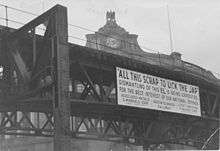
In the early 1920s, the fishing and maritime industries in Boston hit hard times, and passenger loads along the Atlantic Ave El dropped. With the construction of the Sumner Tunnel and the cessation of ferry service on Boston Harbor, ridership between North and South Station dropped precipitously.[4] The Atlantic Avenue Elevated was closed for good on October 1, 1938,[1] and torn down in 1942 for scrap metal for World War II.
The Union Freight Railroad ran underneath the El on Atlantic Avenue and Commercial Street, carrying freight between the lines terminating in North Station and South Station.
References
- 1 2 3 4 5 Belcher, Jonathan (27 June 2015). "Changes to Transit Service in the MBTA district 1964-2015" (PDF). NETransit. Retrieved 14 February 2016.
- ↑ world.nycsubway.org/United States/Boston, Massachusetts/MBTA Orange Line
- ↑ | About the MBTA History The Rapid Transit Commission and the BERY | MBTA.com
- ↑ MIT OpenCourseWare | Civil and Environmental Engineering | 1.012 Introduction to Civil Engineering Design, Spring 2002 | Readings | detail Archived September 20, 2006, at the Wayback Machine.
| Subway lines (List of stations) |
| |||||||||||
|---|---|---|---|---|---|---|---|---|---|---|---|---|
| Commuter Rail lines (List of stations) |
| |||||||||||
| Bus routes (List of routes) | ||||||||||||
| Other services | ||||||||||||
| Component parts of system lines | ||||||||||||
| Capital projects |
| |||||||||||
| History |
| |||||||||||
| Other | ||||||||||||