Hurricane Hernan (2008)
| Category 3 major hurricane (SSHWS/NWS) | |
 Hurricane Hernan near peak intensity | |
| Formed | August 6, 2008 |
|---|---|
| Dissipated | August 12, 2008 |
| Highest winds |
1-minute sustained: 120 mph (195 km/h) |
| Lowest pressure | 956 mbar (hPa); 28.23 inHg |
| Fatalities | None reported |
| Damage | None |
| Areas affected | Hawaii |
| Part of the 2008 Pacific hurricane season | |
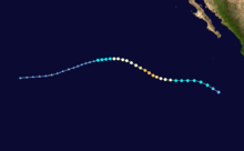
Hurricane Hernan was the ninth tropical depression, eighth named storm, fifth hurricane, and first major hurricane of the 2008 Pacific hurricane season. Hernan developed out of a tropical wave that formed off the east coast of Africa on July 24. Over the next week, the wave traversed the Atlantic without development and entered the Eastern Pacific basin on August 2. The wave became better organized over the next several days and was declared Tropical Depression Nine-E on August 6. The depression quickly became Tropical Storm Hernan later that day. Hernan steadily intensified over the next two days and was upgraded to a hurricane on the morning of August 8.
Hernan continued to intensify and became the first major hurricane—a storm with winds of 111 mph (178 km/h) or higher—of the season on August 9. After reaching major hurricane status, Hernan steadily weakened to a minimal hurricane. The weakening continued, and Hernan was further downgraded to a tropical storm on August 11. As Hernan moved over cold waters, the convection associated with the storm dissipated, leaving only a swirl of clouds. By the morning of August 12, almost all of the convection associated with Hernan had dissipated and the system was declared a remnant low-pressure area. The remnants of the hurricane caused light rain to Hawaii.
Origins
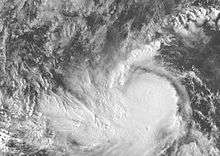
On July 24, a tropical wave emerged from the east coast of Africa, near the Cape Verde Islands. The wave was disorganized and failed to develop convection as it traversed the Atlantic Ocean| over the next several days. The wave eventually entered the Eastern Pacific basin on August 2, and interacted with a broad area of cyclonic flow located a few hundred miles south of Mexico.[1] The wave became better organized throughout the day, and [2] an area of low pressure formed 660 mi (1060 km) south of Manzanillo, Mexico on August 5.[1] Strong convection began to develop.[3] That day, a banding feature formed[4] On the morning of August 6, a Tropical Cyclone Formation Alert was issued.[5] Later in the day, the National Hurricane Center determined that the system had developed sufficient convection to be declared Tropical Depression Nine-E while located 775 mi (1230 km) to the south-southwest of the southern tip of Baja California Sur.[1] However, the storm was operationally believed to have become a depression several hours later.[6]
Tropical Depression Nine-E was influenced by a high pressure area located over Mexico, causing it to move 16 mph (26 km/h) to the north-west. The depression was upgraded to Tropical Storm Hernan overnight as the storm became more organized.[7] Although Hernan was located over warm waters, moderate wind shear prevented the storm from intensifying quickly, and the storm slowed.[8] Hernan slowly became better organized throughout the night,[9] but wind shear continued to impair Hernan through the morning; as a result, most of the tropical cyclone forecast models did not predict Hernan to become a hurricane.[10]
Intensification and peak strength
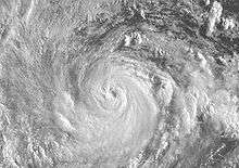
In the early afternoon, an eye feature began to form; subsequently, Hernan was nearing hurricane status.[11] However, by the nighttime hours, a microwave satellite found that the center of Hernan was located to the west-southwest of the eye feature, and the intensification ceased for the rest of the day and into the morning of August 8.[12][13] Later in the morning, the center of Hernan was determined to be located underneath the eye and was determined to have become a hurricane, the fifth of the season, during the afternoon of August 8.[14] Throughout the day, the eye became better defined, indicating that moderate northeasterly wind shear had already begun to diminish. Despite a cloud-filled eye, meteorologists showed Hernan peaking as a Category 2 hurricane overnight.[15][16]
Early on August 9, Hernan was upgraded to a Category 2 hurricane, with winds of 100 mph (155 km/h). Convection around the eye continued become more symmetrical, though the National Hurricane Center had stated that Hernan had most likely reached its peak intensity or was very close to doing so.[17] However, the eye suddenly became better defined. Based on this, Hernan was upgraded to a major hurricane.[18] The intensity of Hernan was uncertain, as there was some difference between intensity estimates.[19] Hernan maintained its appearance through the evening and it was stated that the peak intensity of the storm may have been 125 mph (205 km/h).[20] Overnight, Hernan moved over cooler waters and started to weaken. Although the eye remained well defined, outflow to all the southwestern semicircle became poor.[21]
Weakening and dissipation
Hernan rapidly weakened overnight and was barely a Category 2 in the afternoon hours of August 10 as it moved over cooler waters.[22] The erosion of the eyewall was later found to be caused by an eyewall replacement cycle that rapidly completed itself during the afternoon. Continuing to slowly weaken,[23] Hernan was soon downgraded to a strong Category 1.[24] The newly formed eye began to shrink and deteriorate through the early afternoon, but Hernan briefly stopped weakening.[25] Initially, Hernan's strong circulation allowed it to maintain hurricane status over 24 °C waters.[26]
Early on August 11, Hernan was downgraded to a tropical storm.[27] Deep convection diminished around the center of the storm[28] and by August 12, almost all of the deep convection dissipated as Hernan continued to weaken.[29] Over 23 °C water,[30] only a swirl of clouds remained and the storm was barely a tropical system.[31] Later that night, Hernan had degenerated into a remnant low, and the final advisory was issued by the National Hurricane Center.[32] The remnant low still retained tropical storm-force winds for a short while before weakening further by the next morning. The low moved towards the west-southwest over the next several days before dissipating 460 mi (740 km) southeast of the Island of Hawaii on August 16.[1] The remnant low-pressure area of Hernan later brought moisture to the island of Hawaii, causing cloud and shower activity. The associated rainfall was light and insignificant.[33]
See also
- 2008 Pacific hurricane season
- List of Pacific hurricanes
- Timeline of the 2008 Pacific hurricane season
References
- 1 2 3 4 Daniel P. Brown (2008). "Hurricane Hernan Tropical Cyclone Report" (PDF). National Hurricane Center. Retrieved 2008-10-18.
- ↑ Aguirre (2008). "Tropical Weather Discussion August 5, 2008 15Z". National Hurricane Center. Retrieved 2008-10-04.
- ↑ Aguirre (2008). "Tropical Weather Discussion August 4, 2008 21Z". National Hurricane Center. Retrieved 2008-09-27.
- ↑ Aguirre (2008). "Tropical Weather Discussion August 5, 2008 21Z". National Hurricane Center. Retrieved 2008-09-27.
- ↑ Cobb (2008). "Tropical Weather Discussion August 6, 2008 03Z". National Hurricane Center. Retrieved 2008-09-27.
- ↑ Knabb (2008). "Tropical Depression Nine-E Public Advisory One". National Hurricane Center. Retrieved 2008-08-30.
- ↑ Associated Press (2008-08-06). "Tropical storm forms off Mexico". Fox News. Retrieved 2008-10-18.
- ↑ Brown (2008). "Tropical Storm Hernan Discussion Two". National Hurricane Center. Retrieved 2008-08-31.
- ↑ Pasch (2008). "Tropical Storm Hernan Discussion Three". National Hurricane Center. Retrieved 2008-09-25.
- ↑ Avila (2008). "Tropical Storm Hernan Discussion Four". National Hurricane Center. Retrieved 2008-09-25.
- ↑ Knabb (2008). "Tropical Storm Hernan Discussion Five". National Hurricane Center. Retrieved 2008-09-25.
- ↑ Beven (2008). "Tropical Storm Hernan Discussion Six". National Hurricane Center. Retrieved 2008-09-25.
- ↑ Avila (2008). "Tropical Storm Hernan Discussion Seven". National Hurricane Center. Retrieved 2008-09-25.
- ↑ Knabb/Kimberlain (2008). "Hurricane Hernan Discussion Eight". National Hurricane Center. Retrieved 2008-09-26.
- ↑ Kimberlain/Brown (2008). "Hurricane Hernan Discussion Nine". National Hurricane Center. Retrieved 2008-09-26.
- ↑ Beven (2008). "Hurricane Hernan Discussion Ten". National Hurricane Center. Retrieved 2008-09-26.
- ↑ Rhome (2008). "Hurricane Hernan Discussion Eleven". National Hurricane Center. Retrieved 2008-09-26.
- ↑ Rhome (2008). "Hurricane Hernan Public Advisory Nineteen". National Hurricane Center. Retrieved 2008-10-08.
- ↑ Knabb (2008). "Hurricane Hernan Discussion Twelve". National Hurricane Center. Retrieved 2008-09-26.
- ↑ Brown (2008). "Hurricane Hernan Discussion Thirteen". National Hurricane Center. Retrieved 2008-09-26.
- ↑ Beven (2008). "Hurricane Hernan Discussion Fourteen". National Hurricane Center. Retrieved 2008-09-26.
- ↑ Rhome (2008). "Hurricane Hernan Discussion Fifteen". National Hurricane Center. Retrieved 2008-09-26.
- ↑ Knabb (2008). "Hurricane Hernan Discussion Seventeen". National Hurricane Center. Retrieved 2008-09-26.
- ↑ National Hurricane Center; Hurricane Research Division; Central Pacific Hurricane Center. "The Northeast and North Central Pacific hurricane database 1949–2015". United States National Oceanic and Atmospheric Administration's National Weather Service. A guide on how to read the database is available here.
- ↑ Blake (2008). "Hurricane Hernan Discussion Eighteen". National Hurricane Center. Retrieved 2008-09-26.
- ↑ Berg/Pasch (2008). "Hurricane Hernan Discussion Twenty". National Hurricane Center. Retrieved 2008-09-26.
- ↑ Stewart/Pasch (2008). "Tropical Storm Hernan Discussion Twenty-One". National Hurricane Center. Retrieved 2008-09-26.
- ↑ Blake (2008). "Tropical Storm Hernan Discussion Twenty-Two". National Hurricane Center. Retrieved 2008-09-26.
- ↑ Rhome (2008). "Tropical Storm Hernan Discussion Twenty-Three". National Hurricane Center. Retrieved 2008-09-26.
- ↑ Berg/Brown (2008). "Tropical Storm Hernan Discussion Twenty-Four". National Hurricane Center. Retrieved 2008-09-26.
- ↑ Berg/Brown (2008). "Tropical Storm Hernan Discussion Twenty-Five". National Hurricane Center. Retrieved 2008-09-26.
- ↑ Blake (2008). "Remnant Low Hernan Discussion Twenty-Six". National Hurricane Center. Retrieved 2008-09-26.
- ↑ National Weather Service (2008). "August 2008 Precipitation Summary". National Weather Service in Honolulu, Hawaii. Retrieved 2008-11-03.
External links
| Wikimedia Commons has media related to Hurricane Hernan (2008). |
- The NHC's archive on Hurricane Hernan
- The NHC's Tropical Cyclone Report on Hurricane Hernan
- The NHC's Tropical Cyclone Outlook for the Eastern Pacific
Tropical cyclones of the 2008 Pacific hurricane season | ||
|---|---|---|
 | ||
| ||