Hurricane Elida (2008)
| Category 2 hurricane (SSHWS/NWS) | |
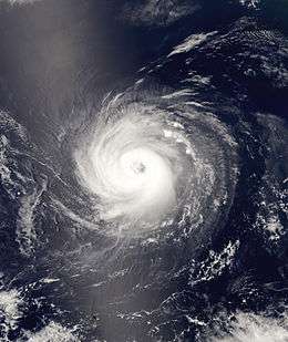 Hurricane Elida at peak intensity | |
| Formed | July 11, 2008 |
|---|---|
| Dissipated | July 19, 2008 |
| Highest winds |
1-minute sustained: 105 mph (165 km/h) |
| Lowest pressure | 970 mbar (hPa); 28.64 inHg |
| Fatalities | None |
| Damage | None |
| Areas affected | Hawaii |
| Part of the 2008 Pacific hurricane season | |
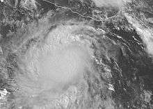
Hurricane Elida was the sixth tropical cyclone, fifth named storm, and second hurricane of the 2008 Pacific hurricane season. Elida formed out of a weak tropical wave which formed off the western coast of Central America on July 8. The wave remained poorly organized over the next two days before developing a surface low. The low was declared Tropical Depression Six-E on July 11 while located to the south of Guatemala. The depression intensified into Tropical Storm Elida the next morning. It intensified steadily over the next two days before being upgraded to a hurricane. The storm fluctuated in intensity over the next several days before reaching its peak intensity on July 16 with winds of 105 mph (165 km/h). Elida slowly weakened as it passed over cooling waters and was downgraded to a tropical storm on July 18 and further downgraded to a tropical depression on July 19. The cyclone degenerated into a remnant low shortly after, and completely dissipated on July 21 over open waters.
Meteorological history

Hurricane Elida developed out of a weak tropical wave which formed off the western coast of Central America on July 8. It is possible that the wave formed in the Atlantic Ocean, but there is little evidence to support this theory. The system remained poorly organized for two days before gaining enough convection to be classified using the Dvorak technique on July 10, while located 290 mi (465 km) south of Guatemala. Later that day, a surface low developed but convection remained minimal. During the night and through the morning of July 11, convection increased sufficiently and a tropical cyclone formation alert was issued. By the end of the day, the storm had become Tropical Depression Six-E, six hours earlier than the operational data.[1][2] At the time of the upgrade, the depression was located 360 mi (580 km) south-southeast of Puerto Angel, Mexico. The depression was moving towards the west-northwest at 16 mph (26 km/h) due to a low to mid-level ridge located to the north of the storm.[1]
The depression was upgraded to Tropical Storm Elida early on July 12 while located 200 mi (370 km) south of Puerto Angel, Mexico.[3] Elida's forward motion slowed somewhat as it neared the southwestern edge of the mid-level ridge. Deep convection developed around the center of circulation and a strong banding feature formed along the western side of the storm.[4] Slow strengthening took place throughout the morning as the center remained underneath the deep convection. Outflow to the north of the storm was slightly restricted, indicating that there was some easterly wind shear.[5] During the afternoon, a well defined banding feature appeared, but the outflow to the north remained highly constricted. Elida began to move slightly faster, still being influenced by the mid-level ridge. The foreword motion was forecast to slow down in the two- to three-day range as it moved away from the ridge.[6] Overnight, wind shear began to weaken and outflow to the north of Elida was established.[7] By the morning of July 13, banding features and outflow were present all around the storm, but wind shear managed to keep the center of Elida slightly displaced from the deepest convection. The movement of a weakening mid to upper-level trough would allow Elida to make a westerly turn.[8] Later in the morning, the wind shear lessened[9] and in the early afternoon, a burst of convection near the center of Elida had formed, but subsequently weakened.[10]
Although Elida initially failed to develop an eyewall.[11] in the early afternoon hours, satellite indicated the formation of an eye. Based on this, Elida was upgraded into a hurricane.[12] In the late morning hours, Elida intensified slightly.[13] and a ragged eye appeared in the afternoon as the structure of the storm improved. At this point, forecasters thought the Elida had peaked in intensity or was near its peak. Elida's direction shifted from a west-northwest to west as the ridge located to the north of the storm began influencing the trajectory.[14] The eye disappeared shortly afterwords.[15] as easterly wind shear began to increase.[16] Elida slowly weakened[17] and by the afternoon, Elida was barely holding onto hurricane status.[18] Despite this, Elida became better organized overnight as convection wrapped around the eye.[19]
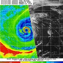
On the morning of July 16, the eye appeared on infrared satellite and cirrus outflow improved all around the system; however, Elida was nearing cooler waters. The mid-level ridge to the north of Elida was now forecast to move with the storm, ensuring westward motion and slightly increasing the foreword speed to 12 mph (19 km/h). Elida accelerated slightly and maintained a westerly motion.[1][20] The eye quickly disappeared from infrared satellite later in the morning, but deep convection persisted on the eastern side of the center of circulation.[21] In the afternoon, an eye appeared embedded in the deep convection and Elida intensified into a category two hurricane with winds of 105 mph (165 km/) while located 630 mi (1015 km) southwest of Cabo San Lucas, Mexico.[1][22] By the nighttime hours, thunderstorm activity in the northern semicircle of Elida waned[23] and cold waters began to take their toll on Elida as the eye became cloud filled and less distinct.[24] In the late morning, Elida weakened to a category one hurricane as determined in the tropical cyclone report.[1] Despite continuing deep convection near the center of Elida and even an embedded eye, the center was lagging behind, making the storm slightly tilted.[25] Elida produced a large amount of deep convection overnight, but the winds continued to lessen. The storm continued to move over colder waters, but wind shear was forecast to lessen, leading to slow, steady weakening.[26]
By the morning of July 18, thunderstorm activity associated with Elida diminished further and the storm was downgraded to a tropical storm.[27] Despite being over very cool waters, Elida managed to maintain a small area of deep convection as it slowly weakened.[28] By the afternoon, most of the convection had dissipated and all that remained.[29] The small area of convection shifted to the east side of the center overnight, allowing Elida to remain a tropical storm with winds barely at 40 mph (65 km/h).[30] By the morning of July 19, Elida was traversing waters of 23°C (73°F) and all the deep convection had dissipated. Due to the lack of convection, Elida was downgraded to a tropical depression.[31] Cold waters prevented any convection from redeveloping in the late morning, and it was unlikely that any convection would form.[32] Elida was later declared a remnant low that afternoon as the system had been devoid of convection for hours.[33] The remnant low continued moving towards the west-southwest before dissipating into an open trough on July 21 while located 690 mi (1,110 km) east-southeast of the Hawaiian Islands.[1]
Preparations and impact
Due to the proximity of Elida to Mexico, the Government of Mexico warned residents about the possibility of heavy rains from the outer edges of the storm.[34] Thunderstorms related to Elida developed over Oaxaca, Guerrero, Michoacán, Colima and Jalisco.[35] In Nayarit, Elida produced storms that dropped torrential rainfall and hail that injured at least one person. The rainfall resulted in the formation of a lake roughly 45 cm (18 in) deep. Several trees feel, blocking streets for several hours. Street flooding reached a depth of 20 cm (7.9 in), inundating shops and some homes.[36] Indirect effects, such as large swells, were felt along the Mexican coastline as the storm produced waves up to 4 m (13 ft).[37] However, as trade winds increased during the middle of July, the remnants of Elida brought rainfall to east-facing slopes of the Island of Hawaii and Maui. Frequent rain showers produced 2 to 6 inches (51 to 152 mm) of precipitation in those regions, but no significant flooding occurred.[38]
See also
- Timeline of the 2008 Pacific hurricane season
- List of Hawaii hurricanes
- Other storms of the same name
References
- 1 2 3 4 5 6 James L. Franklin (2008). "Hurricane Elida Tropical Cyclone Report" (PDF). National Hurricane Center. Retrieved 2008-10-01.
- ↑ Roberts/Knabb (2008). "Tropical Depression Six-E Public Advisory Number One". National Hurricane Center. Retrieved 2008-10-01.
- ↑ Roberts/Beven (2008). "Tropical Storm Elida Public Advisory Number Two". National Hurricane Center. Retrieved 2008-10-01.
- ↑ Roberts/Beven (2008). "Tropical Storm Elida Discussion Number Two". National Hurricane Center. Retrieved 2008-10-01.
- ↑ Brown (2008). "Tropical Storm Elida Discussion Number Three". National Hurricane Center. Retrieved 2008-10-01.
- ↑ Brown (2008). "Tropical Storm Elida Discussion Number Four". National Hurricane Center. Retrieved 2008-10-01.
- ↑ Roberts/Knabb (2008). "Tropical Storm Elida Discussion Number Five". National Hurricane Center. Retrieved 2008-10-01.
- ↑ Roberts/Beven (2008). "Tropical Storm Elida Discussion Number Six". National Hurricane Center. Retrieved 2008-10-01.
- ↑ Blake (2008). "Tropical Storm Elida Discussion Number Seven". National Hurricane Center. Retrieved 2008-10-01.
- ↑ Blake (2008). "Tropical Storm Elida Discussion Number Eight". National Hurricane Center. Retrieved 2008-10-01.
- ↑ Brown (2008). "Tropical Storm Elida Discussion Number Nine". National Hurricane Center. Retrieved 2008-10-01.
- ↑ Rhome (2008). "Hurricane Elida Discussion Number Ten". National Hurricane Center. Retrieved 2008-10-01.
- ↑ Landsea/Franklin (2008). "Hurricane Elida Discussion Number Eleven". National Hurricane Center. Retrieved 2008-10-01.
- ↑ Landsea/Franklin (2008). "Hurricane Elida Discussion Number Twelve". National Hurricane Center. Retrieved 2008-10-04.
- ↑ Brown (2008). "Hurricane Elida Discussion Number Thirteen". National Hurricane Center. Retrieved 2008-10-04.
- ↑ Rhome (2008). "Hurricane Elida Discussion Number Fourteen". National Hurricane Center. Retrieved 2008-10-04.
- ↑ Bann (2008). "Hurricane Elida Discussion Number Fifteen". National Hurricane Center. Retrieved 2008-10-04.
- ↑ Bann (2008). "Hurricane Elida Discussion Number Sixteen". National Hurricane Center. Retrieved 2008-10-04.
- ↑ Franklin (2008). "Hurricane Elida Discussion Number Seventeen". National Hurricane Center. Retrieved 2008-10-04.
- ↑ Franklin (2008). "Hurricane Elida Discussion Number Eighteen". National Hurricane Center. Retrieved 2008-10-04.
- ↑ Avila (2008). "Hurricane Elida Discussion Number Nineteen". National Hurricane Center. Retrieved 2008-10-04.
- ↑ Avila (2008). "Hurricane Elida Discussion Number Twenty". National Hurricane Center. Retrieved 2008-10-04.
- ↑ Franklin (2008). "Hurricane Elida Discussion Number Twenty-One". National Hurricane Center. Retrieved 2008-10-04.
- ↑ Avila (2008). "Hurricane Elida Discussion Number Twenty-Two". National Hurricane Center. Retrieved 2008-10-04.
- ↑ Knabb (2008). "Hurricane Elida Discussion Number Twenty-Four". National Hurricane Center. Retrieved 2008-10-04.
- ↑ Roberts/Rhome (2008). "Hurricane Elida Discussion Number Twenty-Five". National Hurricane Center. Retrieved 2008-10-04.
- ↑ Roberts/Avila (2008). "Tropical Storm Elida Discussion Number Twenty-Six". National Hurricane Center. Retrieved 2008-10-04.
- ↑ Knabb (2008). "Tropical Storm Elida Discussion Number Twenty-Seven". National Hurricane Center. Retrieved 2008-10-04.
- ↑ Knabb (2008). "Tropical Storm Elida Discussion Number Twenty-Eight". National Hurricane Center. Retrieved 2008-10-04.
- ↑ Roberts/Franklin (2008). "Tropical Storm Elida Discussion Number Twenty-Nine". National Hurricane Center. Retrieved 2008-10-04.
- ↑ Rhome (2008). "Tropical Depression Elida Discussion Number Thirty". National Hurricane Center. Retrieved 2008-10-04.
- ↑ Knabb (2008). "Tropical Depression Elida Discussion Number Thirty-One". National Hurricane Center. Retrieved 2008-10-04.
- ↑ Knabb (2008). "Remnant Low Elida Discussion Number Thirty-Two". National Hurricane Center. Retrieved 2008-10-04.
- ↑ Staff Writer (2008-07-12). "Quadratín, Podría 'Elida' afectar a Michoacán" (in Spanish). Quadratín. Retrieved 2009-08-01.
- ↑ Staff Writer (2008-07-13). ""Elida" gana fuerza, pero se aleja de las costas del Pacífico" (in Spanish). El Periódico de México. Retrieved 2009-08-01.
- ↑ Angélica Cureño (2008-07-13). "Tormenta y caos en Tepic" (in Spanish). Periódico Express. Retrieved 2009-08-01.
- ↑ Gustavo Alonso Alvarez (2008-07-14). "Elida podría generar lluvias en BCS" (in Spanish). El Sudcaliforniano. Retrieved 2009-08-01.
- ↑ Honolulu National Weather Service (2008). "July 2008 Precipitation Summary". National Weather Service. Archived from the original on 2008-10-02. Retrieved 2009-03-28.
External links
| Wikimedia Commons has media related to Hurricane Elida (2008). |
- The NHC's archive on Hurricane Elida
- The NHC's Tropical Cyclone Report on Hurricane Elida
- The NHC's Tropical Cyclone Outlook for the Eastern Pacific
Tropical cyclones of the 2008 Pacific hurricane season | ||
|---|---|---|
 | ||
| ||