Hopeton, Oklahoma
| Hopeton, Oklahoma | |
|---|---|
| Unincorporated community | |
 Hopeton, Oklahoma | |
| Coordinates: 36°41′17″N 98°39′57″W / 36.68806°N 98.66583°WCoordinates: 36°41′17″N 98°39′57″W / 36.68806°N 98.66583°W | |
| Country | United States |
| State | Oklahoma |
| County | Woods |
| Elevation | 1,414 ft (431 m) |
| Time zone | Central (CST) (UTC-6) |
| • Summer (DST) | CDT (UTC-5) |
| ZIP code | 73746 |
| Area code(s) | 580 |
| GNIS feature ID | 1093915[1] |
Hopeton is an unincorporated community in Woods County, Oklahoma, United States.[1] Hopeton is located along U.S. Route 281 8 miles (13 km) south of Alva. Hopeton has a post office with ZIP code 73746.[2][3]
References
- 1 2 "Hopeton". Geographic Names Information System. United States Geological Survey.
- ↑ United States Postal Service (2012). "USPS - Look Up a ZIP Code". Retrieved 2012-02-15.
- ↑ "Postmaster Finder - Post Offices by ZIP Code". United States Postal Service. Retrieved April 18, 2014.
Municipalities and communities of Woods County, Oklahoma, United States | ||
|---|---|---|
| Cities | 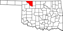 | |
| Towns | ||
| Unincorporated communities | ||
This article is issued from Wikipedia - version of the 7/29/2014. The text is available under the Creative Commons Attribution/Share Alike but additional terms may apply for the media files.