Hiawassee, Georgia
| Hiawassee, Georgia | |
|---|---|
| Town | |
|
Towns County Courthouse in Hiawassee | |
 Location in Towns County and the state of Georgia | |
| Coordinates: 34°56′58″N 83°45′18″W / 34.94944°N 83.75500°WCoordinates: 34°56′58″N 83°45′18″W / 34.94944°N 83.75500°W | |
| Country | United States |
| State | Georgia |
| County | Towns |
| Area | |
| • Total | 2.2 sq mi (5.6 km2) |
| • Land | 1.7 sq mi (4.4 km2) |
| • Water | 0.5 sq mi (1.2 km2) |
| Elevation | 1,972 ft (601 m) |
| Population (2010) | |
| • Total | 880 |
| • Density | 367.3/sq mi (144.3/km2) |
| Time zone | Eastern (EST) (UTC-5) |
| • Summer (DST) | EDT (UTC-4) |
| ZIP code | 30546 |
| Area code(s) | 706 |
| FIPS code | 13-38124[1] |
| GNIS feature ID | 0328122[2] |

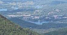
Hiawassee is the county seat of Towns County, Georgia, United States.[3] The community's population was 880 at the 2010 census. Its name comes from the Cherokee -- or perhaps Creek -- word Ayuhwasi, which means meadow,[4] (A variant spelling, "Hiwassee," is used for the local river and some other Appalachian place names.)
History
Settled about 1820, Hiawassee was designated seat of the newly formed Towns County in 1856. It was incorporated as a town in 1870 and as a city in 1916 But the city of Hiawassee was named after a Native American princess.[5]
Geography
Hiawassee is located on the Hiwassee River at 34°56′58″N 83°45′18″W / 34.94944°N 83.75500°W (34.949428, -83.755078).[6]
According to the United States Census Bureau, the town has a total area of 2.2 square miles (5.7 km2), of which, 1.7 square miles (4.4 km2) is land and 0.5 square miles (1.3 km2) (21.86%) is water.
Hiawassee is approximately 2000 feet (609 m) above sea level.[2]
Demographics
| Historical population | |||
|---|---|---|---|
| Census | Pop. | %± | |
| 1880 | 104 | — | |
| 1910 | 226 | — | |
| 1920 | 146 | −35.4% | |
| 1930 | 169 | 15.8% | |
| 1940 | 163 | −3.6% | |
| 1950 | 375 | 130.1% | |
| 1960 | 455 | 21.3% | |
| 1970 | 415 | −8.8% | |
| 1980 | 491 | 18.3% | |
| 1990 | 547 | 11.4% | |
| 2000 | 808 | 47.7% | |
| 2010 | 880 | 8.9% | |
| Est. 2015 | 906 | [7] | 3.0% |
As of the 2010 United States Census, there were 880 people residing in the city. The racial makeup of the city was 95.2% White, 0.3% Black, 0.1% Native American, 1.3% Asian and 0.3% from two or more races. 2.7% were Hispanic or Latino of any race.
As of the census[1] of 2000, there were 810 people, 355 households, and 203 families residing in the town. The population density was 479.5 people per square mile (184.6/km²). There were 527 housing units at an average density of 312.7 per square mile (120.4/km²). The racial makeup of the town was 97.40% White, 0.25% African American, 0.12% Native American, 1.73% Asian, 0.37% from other races, and 0.12% from two or more races. Hispanic or Latino of any race were 1.61% of the population.
There were 355 households out of which 14.1% had children under the age of 18 living with them, 45.6% were married couples living together, 10.1% had a female householder with no husband present, and 42.8% were non-families. 40.3% of all households were made up of individuals and 24.2% had someone living alone who was 65 years of age or older. The average household size was 1.86 and the average family size was 2.39.
In the town the population was spread out with 10.0% under the age of 18, 5.4% from 18 to 24, 13.1% from 25 to 44, 25.1% from 45 to 64, and 46.3% who were 65 years of age or older. The median age was 62 years. For every 100 females there were 70.5 males. For every 100 females age 18 and over, there were 65.6 males.
The median income for a household in the town was $26,615, and the median income for a family was $31,458. Males had a median income of $28,929 versus $22,917 for females. The per capita income for the town was $19,957. About 12.6% of families and 16.0% of the population were below the poverty line, including 28.3% of those under age 18 and 10.2% of those age 65 or over.
Education
Towns County School District
The Towns County School District holds grades pre-school to grade twelve, and consists of one elementary school, a middle school and a high school.[9] The district has 144 full-time teachers and over 2,408 students.[10]
- Towns County Elementary School
- Towns County Middle School
- Towns County High School
Points of interest
References
- 1 2 "American FactFinder". United States Census Bureau. Retrieved 2008-01-31.
- 1 2 "US Board on Geographic Names". United States Geological Survey. 2007-10-25. Retrieved 2008-01-31.
- ↑ "Find a County". National Association of Counties. Retrieved 2011-06-07.
- ↑ "The Names Stayed". Calhoun Times and Gordon County News. August 29, 1990. p. 64. Retrieved 29 April 2015.
- ↑ Hellmann, Paul T. (May 13, 2013). Historical Gazetteer of the United States. Routledge. p. 233. Retrieved 30 November 2013.
- ↑ "US Gazetteer files: 2010, 2000, and 1990". United States Census Bureau. 2011-02-12. Retrieved 2011-04-23.
- ↑ "Annual Estimates of the Resident Population for Incorporated Places: April 1, 2010 to July 1, 2015". Retrieved July 2, 2016.
- ↑ "Census of Population and Housing". Census.gov. Retrieved June 4, 2015.
- ↑ Georgia Board of Education, Retrieved June 28, 2010.
- ↑ School Stats, Retrieved June 28, 2010.
Municipalities and communities of Towns County, Georgia, United States | ||
|---|---|---|
| City | 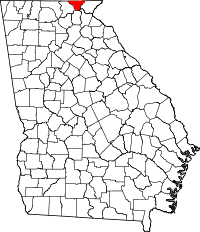 | |
| Town | ||
| CDP | ||