Hebe Haven
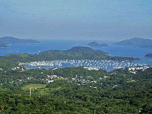
Hebe Haven, also known as Pak Sha Wan (Chinese: 白沙灣; pinyin: Báishā Wān; literally: "white sand bay"), is a harbour in the south shore of Sai Kung Peninsula in Hong Kong.
The harbour has one opening to Port Shelter in its south. A long peninsula spanning south from Tsiu Hang (蕉坑) hugs the Hebe Haven and separates it from Inner Port Shelter (Sai Kung Hoi). Villages gathers along its shore and the haven harbours yachts and boats.
There is Sea Scouting activity centre situated by the haven. The haven is an excellent natural harbour and is home to a number of yacht clubs, including the Shelter Cove yacht club (part of the Royal Hong Kong Yacht Club), and Hebe Haven Yacht Club. There are numerous moorings and many boats distributed around the area along with a clearly marked navigational channel. The channel marks are not lit at night.
Geography
Two main rivers run into the haven, Ho Chung River at the west and Tai Chung River in the north west. Tides, sea currents and river drifts form alleviates and beaches in the haven, although the tidal flow is of minimal strength. A number of smaller streams run into the haven, notably one at the extreme north western edge, just north of Pak Sha Wan. The mangrove area surrounding this stream is a good place in Hong Kong to see the black-capped kingfisher, it is not scenic, small in area and it can be accessed at high tide by dinghy only, nevertheless black-capped kingfishers are commonly sighted.
The Ma Nam Wat peninsula forms the eastern edge of the harbour.
The white sands of a beach northwest gives the native name of Pak Sha Wan, which means "white sand bay". It is the name of a village also and became the indigenous name of Hebe Haven.
Villages
Villages that are close to the Hebe Haven includes Tsiu Hang Hau, Tsiu Hang, Che Keng Tuk, Ta Ho Tun Sheung Wai, Ta Ho Tun Ha Wai, Kau Sai San Tsuen, Pak Sha Wan, Pak Wai, Luk Mei Tsuen, Ho Chung New Village, Wo Mei, Nam Wai and Au Tsai Tsuen.
The Marina Cove residential estate is also located in Hebe Haven.
| Wikimedia Commons has media related to Pak Sha Wan. |
Coordinates: 22°22′N 114°16′E / 22.367°N 114.267°E