Havasupai Indian Reservation
| Havasupai Indian Reservation Havsuw’ Baaja | ||
|---|---|---|
| Reservation | ||
| ||
| Capital | Supai | |
| Government | ||
| • Body | Havasupai Tribal Council | |
| • Chairman | Don E. Watahomigie | |
| • Vice Chairman | Edmond Tilousi | |
| Area | ||
| • Total | 763.22 km2 (294.68 sq mi) | |
| Population (2010) | ||
| • Total | 639 | |
| • Density | 0.84/km2 (2.2/sq mi) | |
| Time zone | MST | |

The Havasupai Indian Reservation is a Native American reservation for the Havasupai people, surrounded entirely by the Grand Canyon National Park, in Coconino county in Arizona, United States. It is considered one of America's most remote Indian reservations. The reservation is governed by a seven-member tribal council, led by a chairman who is elected from among the members of the council. The capital of the reservation is Supai, situated at the bottom of Cataract Canyon, one of the tributary canyons of the Grand Canyon. Havasupai is a combination of the words Havasu (meaning "blue-green water") and pai (meaning "people"),[1] thus meaning "people of the blue-green waters".[2]
History
The Havasupai led a semi-nomadic life amongst the canyons and plateaus in and around Havasu Canyon for centuries. In 1882, President Rutherford B. Hayes created the Havasupai Indian Reservation, and restricted the tribe to 518 acres in Havasu Canyon.[3][4] The rest of their ancestral lands were taken by the federal government for public use. According to reports, the Havasupai were completely unaware of the act for several years.[5] The reduction of their lands led to a disruption on the tribe's way of life, and constant tension between the tribe and the U.S. Government.[6]
With the creation of the Grand Canyon National Park in 1919 the reservation was completely surrounded by National Park lands. By agreement with the federal government, the reservation and the trails which led down to it remained sovereign to Havasupai tribe. The tribe continually lobbied the United States to restore more of their ancestral land to them, although to no avail. In the 1950s a superintendent of the Grand Canyon, John McLaughlin, proposed to take over the reservation, but he was rebuffed by the tribe.[6]
Eventually the persistence of the tribe began to pay off. In 1968 the tribe won a case against the government with the Indian Claim Commission.[7] The ruling stated that the lands had been taken illegally from the tribe in 1882, and that the tribe had the right to recover the lands by paying the government fair market value for the property. At a rate of 55 cents an acre, the value of the lands was sent at slightly more than one million dollars. However, the tribe still fought for having the lands returned to them, without having to pay for them. The tribe found support from the Nixon administration, and began to lobby for passage of congressional bill S. 1296, which would return the lands to the tribe.[5] Finally, in 1975, the U.S. Congress passed the Grand Canyon National Park Enlargement Act, which was signed into law by President Gerald Ford on January 4, 1975. Among other things, the Act returned 188,077 acres (76,112 ha) of plateau and canyon lands to the Havasupai, which is what forms the reservation today.[3][6][8]
The tribe still speaks Yuman, one of about 200 indigenous languages still spoken in North America.[9]
Government
The tribe passed their Constitution on March 27, 1939. In it the governing body was defined as a seven-member tribal council, which handles most policy matters. Four of the councilmen were to be elected and serve two years, with the remaining three councilmen being hereditary chiefs of the tribe, who would serve for life. The council is led by a chairman who is elected from among the members of the council.[10] The Bureau of Indian Affairs (BIA) is the entity charged with law enforcement and protection for the Tribe, while the Indian Health Service clinic provides health care and emergency services.
Geography
Located in Coconino County, the reservation sits at the southwest corner of the Grand Canyon National Park, considered one of America's most remote Indian reservations.[9] The nearest community to the Reservation is Peach Springs, Arizona, which lies approximately 64 miles to the southwest. The topography of the Reservation is made up of plateau country, dissected with deep canyons. The plateau itself varies from rolling, gentle slopes, to escarpments of Kaibab Limestone.[3] While similar to other locations within the system of canyons of which it is part, Cataract Canyon is unique due to the high concentrations of travertine in Havasu creek. The canyon itself is the largest largest individual side-canyon to the Grand Canyon. The presence of the travertine is what leads to the aquamarine color of the streams and ponds in the canyon.[4] There is another small settlement at Indian Gardens.[6]
The main population center of the Reservation is centered around Cataract Canyon (also known as Havasu Canyon), where the capital of the reservation, Supai, is located.[4] Supai has been referred to as "the most remote community" in the contiguous United States by the U.S. Department of Agriculture.[11] It is accessible only by helicopter, on foot or by mule. Supai is 8 miles (13 km) from the nearest road and has no automobiles in the community. It is the only place in the United States where mail is still carried out by mules.[12]
Notable geographic features include The Great Thumb, Long Mesa, and Tenderfoot Mesa. The main attraction is Havasu Creek, with aquamarine water (due to the presence of travertine), the stream is one of the longest tributaries on the south side of the Colorado River, and falls 1,400 feet (430 m) over its course. The stream is renowned for its beautiful waterfalls, which include Havasu Falls, Mooney Falls, and Beaver Falls. A fourth well-known falls, Navajo Falls, is no longer in existence following a devastating flood in 2008.[3][13] While Navajo Falls is no longer in existence, the re-routing of the stream created two new falls, which have yet to be officially named, although unofficially they are being called New Navajo Falls and Rock Falls. Each of the falls has its own swimming hole at their base.[14]
Flora and fauna
Non-human denizens of the reservation include canyon tree frogs, cottontail rabbits, rattlesnakes, desert kingsnakes, and california condors.[4]
In the canyons, canyon grapevine and giant Fremont cottonwood trees can be found.[4]
Economy
Tourism is a large portion of the economy of the Reservation. The tribe runs its own tourism office, as well as a café, lodge, and general store. Individual members of the tribe also have small businesses, leading tour groups and packing supplies in and out of the canyon. In 2008, a dam burst upstream, causing a torrent to sweep through the canyon, resulting in significant damage to the natural resources as well as man-made structures. The tourism industry was devastated. The tribe received a one million dollar grant from the San Manuel Band of Mission Indians to assist in the economic recovery of the Reservation.[6]
The tribe also runs a campground in the canyon, as well as the Havasupai Tribal Museum, which displays photography of the reservation, as well as offering tribal crafts for sale. On the second weekend in August, the tribe holds an annual Peach Festival.[3]
Havasu Canyon receives approximately 500 visitors per day during the summer months, and has an annual total of approximately 25,000.[13]
References
- ↑ Bureau of Indian Affairs (1928). The Havasupai Indian Agency, Arizona. Haskell Printing Department. p. 6.
- ↑ "Havasupai Indian Reservation". National Park Service. Archived from the original on November 25, 2016. Retrieved November 25, 2016.
- 1 2 3 4 5 "Havasupai Tribe". Inter Tribal Council of Arizona. Archived from the original on November 25, 2016. Retrieved November 25, 2016.
- 1 2 3 4 5 "Havasupai History & Culture". Arizona Outback Adventures. Archived from the original on November 25, 2016. Retrieved November 25, 2016.
- 1 2 Hirst, Stephen. Havsu ‘Baaja: People of the Blue Green Water. Tempe, Arizona: Walsh and Associates, 1985
- 1 2 3 4 5 "Havasupai Reservation". Arizona State University. Archived from the original on November 25, 2016. Retrieved November 25, 2016.
- ↑ The Havasupai Tribe of the Havasupai Reservation, Arizona, The Navajo Tribe of Indians v. the United States of America 20 Ind. Cl. Comm. 210 (1968)
- ↑ United States Statutes at Large 1974, Volume 88 (PDF), Washington: United States Government Printing Office, 1976, p. 2089, retrieved 2013-05-05
- 1 2 "Havasupai". Grand Canyon Tourist. Archived from the original on November 25, 2016. Retrieved November 25, 2016.
- ↑ "Constitution and By-Laws of the Havasupai Tribe of the Havasupai Reservation Arizona". U.S. Department of the Interior. Archived from the original (PDF) on November 25, 2016. Retrieved November 25, 2016.
- ↑ "USDA Rural Utilities Administrator Visits Supai Tribe in Arizona to Announce a Recovery Act Broadband Project". U.S. Department of Agriculture. Retrieved July 16, 2016.
- ↑ Bill Geist (2000-01-23). "Special Delivery: Mail By Mule". CBS News Sunday Morning. CBS News. Retrieved 2009-09-30.
- 1 2 "Havasupai Indian Reservation". The American Southwest. Archived from the original on November 25, 2016. Retrieved November 25, 2016.
- ↑ "Introducing Havasupai Reservation". Lonely Planet. Archived from the original on November 25, 2016. Retrieved November 25, 2016.
See also: Indigenous peoples of Arizona |
Municipalities and communities of Coconino County, Arizona, United States | ||
|---|---|---|
| Cities | 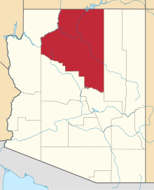 | |
| Towns | ||
| CDPs | ||
| Unincorporated communities |
| |
| Indian reservations | ||
| Ghost town | ||
| Footnotes | ‡This populated place also has portions in an adjacent county or counties | |