Bellemont, Arizona
| Bellemont, Arizona | |
|---|---|
| Unincorporated community | |
|
A field in Bellemont, Arizona | |
 Bellemont, Arizona  Bellemont, Arizona | |
| Coordinates: 35°14′17″N 111°50′01″W / 35.23806°N 111.83361°WCoordinates: 35°14′17″N 111°50′01″W / 35.23806°N 111.83361°W | |
| Country | United States |
| State | Arizona |
| County | Coconino |
| Elevation | 7,132 ft (2,174 m) |
| Time zone | Mountain (MST) (UTC-7) |
| ZIP code | 86015 |
| Area code(s) | 928 |
| GNIS feature ID | 26201[1] |
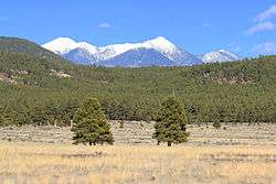
Bellemont is an unincorporated community in Coconino County, Arizona, United States. Bellemont is located along Interstate 40 11 miles (18 km) west-northwest of Flagstaff. Bellemont at an elevation of 7,132 feet above sea level claims to be the highest settlement along the historic Route 66. Bellemont was a known water stop on historic Route 66, due to local springs. As of June 2012 Bellemont has an estimated population of 893.[2]
In October 2010 Bellement was struck by a tornado.[3] The tornado damaged 15 homes in the community, to the point "that they were uninhabitable", resulting in evacuation of about 30 people.[3] A train and 30 recreational vehicles were damaged, but "No serious injuries or deaths were reported."[3]
Bellemont is the location for the Flagstaff field office for the National Weather Service.[4]
Climate
This region experiences warm (but not hot) and dry summers, with no average monthly temperatures above 71.6°F. According to the Köppen Climate Classification system, Bellemont has a Continental climate, abbreviated "Dsb" on climate maps.[5]
See also
References
- ↑ U.S. Geological Survey Geographic Names Information System: Bellemont, Arizona
- ↑ http://factfinder.census.gov/servlet/SAFFPopulation?_event=Search&_zip=86015
- 1 2 3 "Tornadoes derail train, smash homes in N. Arizona," Associated Press, October 6, 2010. Found at yahoo news Archived October 7, 2010, at the Wayback Machine.. Accessed October 6, 2010.
- ↑ http://www.wrh.noaa.gov/fgz/vws/location.php?wfo=fgz
- ↑ Climate Summary for Carpinteria, California
- They Came To The Mountain, by Platt Cline, Northern Arizona University with Northland Press, 1976.
- The Santa Fe Route Railroads of Arizona Vol. 4 by David F. Myrick, Signature Press 1998.
Municipalities and communities of Coconino County, Arizona, United States | ||
|---|---|---|
| Cities | 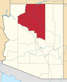 | |
| Towns | ||
| CDPs | ||
| Unincorporated communities |
| |
| Indian reservations | ||
| Ghost town | ||
| Footnotes | ‡This populated place also has portions in an adjacent county or counties | |