Haskell Township, Haskell County, Kansas
| Haskell Township | |
|---|---|
| Township | |
 Location in Haskell County | |
| Coordinates: 37°34′00″N 100°52′22″W / 37.56667°N 100.87278°WCoordinates: 37°34′00″N 100°52′22″W / 37.56667°N 100.87278°W | |
| Country | United States |
| State | Kansas |
| County | Haskell |
| Area | |
| • Total | 192.5 sq mi (498.56 km2) |
| • Land | 192.36 sq mi (498.22 km2) |
| • Water | 0.13 sq mi (0.34 km2) 0.07% |
| Elevation | 2,943 ft (897 m) |
| Population (2000) | |
| • Total | 1,971 |
| • Density | 10.2/sq mi (4/km2) |
| GNIS feature ID | 0470608 |
Haskell Township is a township in Haskell County, Kansas, USA. As of the 2000 census, its population was 1,971.
Geography
Haskell Township covers an area of 192.5 square miles (499 km2) and contains one incorporated settlement, Sublette (the county seat). According to the USGS, it contains two cemeteries: Haskell and Ivanhoe.
Transportation
Haskell Township contains two airports or landing strips: Currey Farms Airport and Sublette Flying Club Land Strip.
References
External links
Municipalities and communities of Haskell County, Kansas, United States | ||
|---|---|---|
| Cities | 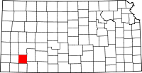 | |
| Townships | ||
This article is issued from Wikipedia - version of the 11/11/2013. The text is available under the Creative Commons Attribution/Share Alike but additional terms may apply for the media files.