Harmans Water

Coordinates: 51°24′13″N 0°44′20″W / 51.403473°N 0.738849°W
Harmans Water is a suburb of Bracknell in Berkshire, England. It takes its name from Harman's Water Lake, long gone.[1] Building of the estate began around 1960 and was the fourth and last estate to be built as part of the original plan for the new town.
The estate lies approximately 1 mile (1.6 km) south-east of the town centre, to the east of the A322 road and south of the A329 road. It is in Harmans Water ward, which following boundary changes now includes parts of Bullbrook, Martins Heron and The Parks.[2]
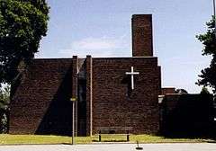
Facilities include a shopping centre, a library, several public houses and Harmans Water Primary School . St. Pauls Church has shared Church of England and United Reformed Church services and is situated adjacent to the shopping centre. There are a few office buildings in Broad Lane but otherwise the estate is largely residential.
The Parks
The Parks is a recent development and is on the site of the former RAF Staff College which closed in 2004. The first phase of the development, of 220 homes was developed by English Partnerships and completed in 2008.[3] As of 2016 development continues with a further 530 homes and is due to be completed in 2017.
Ramslade House, the former headquarters building of the RAF staff college, was originally planned to become a community centre but was demolished in 2016 to make way for a development of 12 townhouses being built by Taylor Wimpey.[4]
References
- ↑ "History of the Hamlets of Winkfield, Berkshire". David Nash Ford. Retrieved 28 September 2012.
- ↑ "Ward Map for Harmans Water" (PDF). Bracknell Forest Council. Retrieved 28 September 2012.
- ↑ "The Parks, Bracknell". English Heritage. Retrieved 4 October 2012.
- ↑ "Uncertain future for Historic Ramslade House". Bracknell Forest Standard. Retrieved 4 October 2012.