Swinley Forest
Swinley Forest is a large expanse of Crown Estate woodland mainly within the civil parishes of Windlesham in Surrey and Winkfield and Crowthorne in Berkshire, England.
Coverage
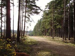
Situated to the south-west of Windsor Great Park, the forest stretches from Bracknell, in the north, to Bagshot, in the south. It is owned and managed by the Crown Estate and comprises over 2,600 acres (11 km2) of woodland across gently undulating hills. Although now mostly a modern plantation of Scots Pines, the area was once part of Windsor Forest. Swinley Forest includes Crowthorne Woods around Caesar's Camp between the Nine Mile Ride and Crowthorne; Swinley Park between Forest Park and the B3017; Bagshot Heath just west of Bagshot; and Swinley Woods around Kings Ride between the B3017 and South Ascot. Much of the woods cover what used to be moorland as indicated by the names of some of the hills, such as Broadmoor, Owlsmoor, Wishmoor, Gormoor, Whitmoor and Englemoor (now Englemere).
History
Swinley Park once surrounded Swinley Lodge where the King kept the Royal Staghounds in Georgian times. It was at the centre of Swinley Walke, one of the sub-divisions of Windsor Forest.
There are a number of late 18th century redoubts scattered throughout the forest. These defensive earth fortifications were built here not as working defences but as training grounds to carry out military exercises in the buildup to the Napoleonic Wars.
In May 2011 forest fires broke out throughout the forest; the cause is believed to be a mixture of the unseasonably dry conditions and arson. Although the fires were stated at the time by the Royal Berkshire Fire and Rescue Service to have been the most extensive fires ever tackled by the service, the extent of the damage to the forest was relatively limited.
Leisure and attractions
Mountain biking
The woods provide some of the best mountain biking[1] in South-East England, with many off-road 'single-track' trails available as well as plenty of fire roads. Mountain biking no longer requires a permit since the introduction of the three marked trails (Green, Blue & Red) and walking is free. Swinley Woods was originally submitted as the proposed venue for the mountain biking event of the 2012 Summer Olympics, however, the distance from the main Olympic Park was considered too great and the heavy forestation along most of the suggested routes would have resulted in poor camera access and views. The event was instead located at Hadleigh Farm near Hadleigh, Essex.
Visitor centre
At Gormoor on the Nine Mile Ride, on the northern edge of Crowthorne Woods, is The Look Out Discovery Centre, operated by Bracknell Forest Borough Council. This is a hands-on science exhibition and nature discovery centre, which also acts as a visitor centre for the forest, providing maps, car parking and bike hire. Most of the self-guided walks and bike trails start and end at the centre.
Caesar's Camp
Adjoining the Look Out is an Iron Age hill fort known as Caesar's Camp. It is the only one in East Berkshire. It has not been excavated but Iron Age coins have been found there. The name only dates from the 18th century.
Go Ape
In 2007, a "Go-Ape" facility was opened to the public, featuring a series of tree-top rope bridges and climbs.
Protection status
Swinley Park and its Brick Pits is a Site of Special Scientific Interest (SSSI) and has protected areas for the birds that live there. As well as the extensive commercial conifer plantations and mixed woodland the nationally rare lowland heath present means Swinley Forest forms part of the Thames Basin Heaths,[2] a designated Special Protection Area (SPA), due to the rare ground nesting birds including wood lark, Dartford warbler and European nightjar which nest in open parts of the forest.
References
- ↑ "Mountain Bikin UK: Trail of the Year: Swinley Forest, Berkshire" (PDF). Gorrick.com. Retrieved 2012-11-27.
- ↑ "RSPB Thames Basin Heaths" (PDF). Rspb.org.uk. Retrieved 2012-11-27.
External links
| Towns, villages and neighbourhoods |
|  | ||||||||||||||||||||||||||
|---|---|---|---|---|---|---|---|---|---|---|---|---|---|---|---|---|---|---|---|---|---|---|---|---|---|---|---|---|
| Parks | ||||||||||||||||||||||||||||
| Listed Churches | ||||||||||||||||||||||||||||
| Education | ||||||||||||||||||||||||||||
| Transport |
| |||||||||||||||||||||||||||
| Buildings and structures | ||||||||||||||||||||||||||||
| Sport | ||||||||||||||||||||||||||||
Places listed are articles or sections notable as settlements, arranged by post town Camberley is the administrative centre and largest single settlement | ||||||||||||||||||||||||||||
Coordinates: 51°22′N 0°44′W / 51.367°N 0.733°W