Hajdúbagos
| Hajdúbagos | ||
|---|---|---|
| ||
 Hajdúbagos | ||
| Coordinates: 47°23′33″N 21°39′55″E / 47.39250°N 21.66528°E | ||
| Country |
| |
| County | Hajdú-Bihar | |
| Area | ||
| • Total | 37.44 km2 (14.46 sq mi) | |
| Population (2001) | ||
| • Total | 1,981 | |
| • Density | 52.91/km2 (137.0/sq mi) | |
| Time zone | CET (UTC+1) | |
| • Summer (DST) | CEST (UTC+2) | |
| Postal code | 4273 | |
| Area code(s) | 52 | |
Hajdúbagos is a village in Hajdú-Bihar county, in the Northern Great Plain region of eastern Hungary.
History
The village was known as "Csirebagos" for a time in the Middle Ages, referring back to the gentry Csir family who held a number of villages in the vicinity between the 12th and 16th centuries.
Geography
It covers an area of 37.44 km2 (14 sq mi) and has a population of 1981 people (2001).
County seat: Debrecen | ||
| Cities and towns | 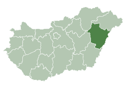 | |
| Villages |
| |
| Other topics |
| |
Coordinates: 47°23′34″N 21°39′55″E / 47.39268°N 21.66519°E
This article is issued from Wikipedia - version of the 9/7/2015. The text is available under the Creative Commons Attribution/Share Alike but additional terms may apply for the media files.