Hai River
| Hai River (海河) | |
| Hai He | |
 Hai River in Tianjin | |
| Country | China |
|---|---|
| States | Tianji, Hebei, Beijing, Henan, Inner Mongolia, Shanxi, Shandong |
| Source | Taihang Mountains、Yan Mountains |
| Mouth | Bohai Sea |
| Length | 1,329 km (826 mi) |
| Basin | 318,200 km2 (122,858 sq mi) |
| Discharge | |
| - average | 717 m3/s (25,321 cu ft/s) |
 Hai River basin | |
| Hai River | |||||||
| Chinese | 海河 | ||||||
|---|---|---|---|---|---|---|---|
| Literal meaning | Sea River | ||||||
| |||||||
| Peiho | |||||||
| Chinese | 白河 | ||||||
| Literal meaning | White River | ||||||
| |||||||
The Hai River, formerly known as the Peiho or Pei Ho, is a Chinese river connecting Beijing to Tianjin and the Bohai Sea.
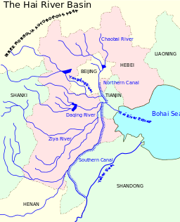
The Hai River at Tianjin is formed by the confluence of five rivers, the Southern Canal, Ziya River, Daqing River, Yongding River, and the Northern Canal. The southern and northern canals are parts of the Grand Canal. The Southern Canal is joined by the Wei River at Linqing. The Northern Canal joins with the Bai He (or Chaobai River) at Tongzhou. The Northern Canal (sharing a channel with Bai He) is also the only waterway from the sea to Beijing. Therefore, early Westerners also called the Hai He the Bai He.
At Tianjin, through the Grand Canal, the Hai connects with the Yellow and Yangtze rivers. The construction of the Grand Canal greatly altered the rivers of the Hai He basin. Previously, the Wei, Ziya Yongding and Bai Rivers flowed separately to the sea. The Grand Canal cut through the lower reaches of these rivers and fused them into one outlet to the sea, in the form of the current Hai He.
Hai He is 1,329 kilometres (826 mi) long measured from the longest tributary. However, the Hai He is only around 70 kilometres (43 mi) from Tianjin to its estuary. Its basin has an area of approximately 319,000 km2 (123,000 sq mi). Its annual flow is only half that of the Yellow River, or one-thirtieth that of the Yangtze River.
History

In 1863 seagoing ships could reach the head of navigation at Tongzhou, but the crooked river was difficult for large vessels.[1] During the Boxer Rebellion, Imperial Chinese forces deployed a weapon called "electric mines" on June 15, at the Baihe river before the Battle of Dagu Forts (1900), to prevent the western Eight-Nation Alliance from sending ships to attack. This was reported by American military intelligence in the United States. War Dept. by the United States. Adjutant-General's Office. Military Information Division.[2][3][4][5]
Like the Yellow River, the Hai is exceedingly muddy because of the powdery soil through which it flows. The silt carried by the water deposits in the lower reaches, sometimes causing flooding. The waters from the five major tributaries only have one shallow outlet to the sea, which makes such floods stronger. Because China's capital (and second largest city), Beijing, and the third largest city, Tianjin, both lie in the Hai He Basin, Hai He floods cause a significant loss. To alleviate flooding, reservoirs have been built and artificial channels dug to divert excess water directly into the sea. For example, the Chaobai River is diverted to the Chaobai Xin River and no longer joins with the Northern Canal.
Due to industrial and urban development in the Hai He Basin, the volume of water flow has greatly decreased. Many smaller tributaries and some of the major tributaries are dry for most of the year. With reduced water flow, water pollution worsens. The water shortage in the Hai He basin is expected to be alleviated by the South-North Water Transfer Project.
See also
References
- ↑ Alexander Michie,The Siberian Overland Route from Peking to Petersburg, 1864
- ↑ United States. Adjutant-General's Office. Military Information Division (1901). Publication, Issue 33. WASHINGTON: G.P.O. p. 533. Retrieved February 19, 2011.(Document (United States. War Dept.))(Original from Harvard University)
- ↑ United States. Adjutant-General's Office. Military Information Division, Stephen L'H. Slocum, Carl Reichmann, Adna Romanga Chaffee (1901). Reports on military operations in South Africa and China. July, 1901. WASHINGTON: Govt. print. off. p. 533. Retrieved February 19, 2011.(Issue 33 of Publication (United States. Adjutant-General's Office. Military Information Division) Issue 143 of Document, United States War Dept Issue 33 of Publication, United States Adjutant-General's Office)
- ↑ Monro MacCloskey (1969). Reilly's Battery: a story of the Boxer Rebellion. R. Rosen Press. p. 95. Retrieved February 19, 2011.(Original from the University of Wisconsin - Madison)
- ↑ Stephan L'H. Slocum, Carl Reichmann, Adna Romanza Chaffee, United States. Adjutant-General's Office. Military Information Division (1901). Reports on military operations in South Africa and China. WASHINGTON: G.P.O. p. 533. Retrieved February 19, 2011.(Issue 143 of Document (United States. War Dept.))(Original from the New York Public Library)
Bibliography
 This article incorporates text from Publication, Issue 33 Document (United States. War Dept.), by United States. Adjutant-General's Office. Military Information Division, a publication from 1901 now in the public domain in the United States.
- This article incorporates text from Reports on military operations in South Africa and China. July, 1901, by United States. Adjutant-General's Office. Military Information Division, Stephen L'H. Slocum, Carl Reichmann, Adna Romanga Chaffee, a publication from 1901 now in the public domain in the United States.
- This article incorporates text from Reports on military operations in South Africa and China, by Stephan L'H. Slocum, Carl Reichmann, Adna Romanza Chaffee, United States. Adjutant-General's Office. Military Information Division, a publication from 1901 now in the public domain in the United States.
Further reading
- Domagalski, J.L., et al. (2001). Comparative water-quality assessment of the Hai He River basin in the People's Republic of China and three similar basins in the United States [U.S. Geological Survey Professional Paper 1647]. Reston, VA: U.S. Department of the Interior, U.S. Geological Survey.
External links
| Wikimedia Commons has media related to: |
Coordinates: 38°57′N 117°43′E / 38.950°N 117.717°E