Hünenberg
| Hünenberg | ||
|---|---|---|
 | ||
| ||
 Hünenberg | ||
|
Location of Hünenberg 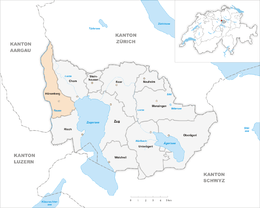 | ||
| Coordinates: 47°11′N 8°26′E / 47.183°N 8.433°ECoordinates: 47°11′N 8°26′E / 47.183°N 8.433°E | ||
| Country | Switzerland | |
| Canton | Zug | |
| District | n.a. | |
| Area[1] | ||
| • Total | 18.45 km2 (7.12 sq mi) | |
| Elevation | 444 m (1,457 ft) | |
| Lowest elevation (Reussspitz) | 388 m (1,273 ft) | |
| Population (Dec 2015[2]) | ||
| • Total | 8,848 | |
| • Density | 480/km2 (1,200/sq mi) | |
| Postal code | 6331 | |
| SFOS number | 1703 | |
| Surrounded by | Cham, Dietwil (AG), Maschwanden (ZH), Merenschwand (AG), Mühlau (AG), Oberrüti (AG), Obfelden (ZH), Risch, Sins (AG), Zug | |
| Twin towns | Banska Stiavnica (Slovakia) | |
| Website |
www SFSO statistics | |

Hünenberg is a municipality in the canton of Zug in Switzerland.
History
Hünenberg is first mentioned in 1173 as de Hunberg, though this document is considered a forgery. In 1185 it was mentioned as de Hunoberg and in 1239 as de Hunaberc.[3]
Geography
Hünenberg has an area, as of 2006, of 18.4 km2 (7.1 sq mi). Of this area, 63.4% is used for agricultural purposes, while 17% is forested. Of the rest of the land, 12.3% is settled (buildings or roads) and the remainder (7.3%) is non-productive (rivers, glaciers or mountains).[4]
The municipality is located between the Reuss river, Lorze river Lake Zug.
Demographics
Hünenberg has a population (as of 31 December 2015) of 8,848.[5] As of 2007, 12.1% of the population was made up of foreign nationals. Over the last 10 years the population has grown at a rate of 21.1%. Most of the population (as of 2000) speaks German (91.7%), with English being second most common ( 1.8%) and French being third ( 1.3%).[4]
In the 2007 federal election the most popular party was the SVP which received 27.5% of the vote. The next three most popular parties were the CVP (26.7%), the FDP (21.9%) and the Green Party (15.3%).[4]
In Hünenberg about 85.9% of the population (between age 25-64) have completed either non-mandatory upper secondary education or additional higher education (either university or a Fachhochschule).[4]
Hünenberg has an unemployment rate of 1.39%. As of 2005, there were 253 people employed in the primary economic sector and about 74 businesses involved in this sector. 1,092 people are employed in the secondary sector and there are 95 businesses in this sector. 2,881 people are employed in the tertiary sector, with 445 businesses in this sector.[4]
The historical population is given in the following table:[3]
| year | population |
|---|---|
| 1771 | 812 |
| 1850 | 1,032 |
| 1900 | 943 |
| 1950 | 1,409 |
| 1970 | 1,819 |
| 1980 | 4,105 |
| 2000 | 6,987 |
Education
The International School of Zug and Luzern has its Riverside campus, housing upper secondary (senior high school) classes, in Hünenberg.[6]
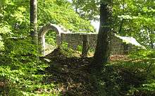
Heritage sites of national significance
The Catholic Church of St. Wolfgang is listed as a heritage sites of national significance.[7]
References
- ↑ Arealstatistik Standard - Gemeindedaten nach 4 Hauptbereichen
- ↑ Swiss Federal Statistical Office - STAT-TAB, online database – Ständige und nichtständige Wohnbevölkerung nach institutionellen Gliederungen, Geburtsort und Staatsangehörigkeit (German) accessed 30 August 2016
- 1 2 Hünenberg in German, French and Italian in the online Historical Dictionary of Switzerland.
- 1 2 3 4 5 Swiss Federal Statistical Office accessed 22-Sep-2009
- ↑ Swiss Federal Statistical Office - STAT-TAB, online database – Ständige und nichtständige Wohnbevölkerung nach institutionellen Gliederungen, Geburtsort und Staatsangehörigkeit (German) accessed 30 August 2016
- ↑ "Contact and Visit Us." International School of Zug and Luzern. Retrieved on 20 October 2015. "Rothusstrasse 4b 6331 Hünenberg, Switzerland"
- ↑ Swiss inventory of cultural property of national and regional significance Archived May 1, 2009, at the Wayback Machine. 21.11.2008 version, (German) accessed 22-Sep-2009
External links
- Hünenberg in German, French and Italian in the online Historical Dictionary of Switzerland.
| Wikimedia Commons has media related to Hünenberg. |