Hægeland
| Hægeland herred | |
|---|---|
| Former Municipality | |
|
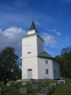
Hægeland church | |
| Coordinates: 58°23′01″N 07°44′26″E / 58.38361°N 7.74056°ECoordinates: 58°23′01″N 07°44′26″E / 58.38361°N 7.74056°E | |
| Country | Norway |
| County | Vest-Agder |
| District | Sørlandet |
| Municipality ID | NO-1015 |
| Adm. Center | Hægeland |
| Area[1] | |
| • Total | 194 km2 (75 sq mi) |
| Split from | Øvrebø og Hægeland in 1896 |
| Merged into | Vennesla in 1964 |
Hægeland is a village and a former municipality in Vest-Agder county in Norway. It is located in the northern part of the present-day municipality of Vennesla, just west of the Kilefjorden.
Name
The municipality (originally the parish) is named after the old Hægeland farm (Old Norse: Helgaland). The first element of the name means "holy" (Old Norse: heilagr and Norwegian: hellig) and the last element (Old Norse: land) is identical with the word land which means "land". This area was important to ancient Norse pagan worship.[1][2]
History
The municipality of Hægeland was established on 1 July 1896 when the old municipality of Øvrebø og Hægeland was divided into the separate municipalities of Hægeland (population: 843) and Øvrebø (population: 888). On 1 January 1964, the municipalities of Hægeland, Vennesla, and most of Øvrebø were merged to form a new Vennesla municipality. Vennesla was previously part of the old municipality of Øvrebø og Hægeland until 1861. Prior to the merger, Hægeland had a population of 849.[3]
References
- 1 2 "Hægeland" (in Norwegian). Store norske leksikon. Retrieved 2009-10-29.
- ↑ Rygh, Oluf (1912). Norske gaardnavne: Lister og Mandals amt (in Norwegian) (9 ed.). Kristiania, Norge: W. C. Fabritius & sønners bogtrikkeri. p. 34.
- ↑ Jukvam, Dag (1999). "Historisk oversikt over endringer i kommune- og fylkesinndelingen" (PDF) (in Norwegian). Statistisk sentralbyrå.
External links
- Weather information for Hægeland (Norwegian)