Gweru District
Coordinates: 19°27′42″S 29°49′14″E / 19.461632°S 29.820595°E
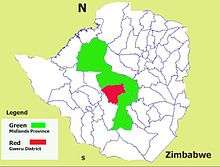
Gweru District is a district in the Midlands Province of Zimbabwe.
Background
Gweru District gets its name from Ikwelo River now Gweru River which has the city as its source and primary drainage basin.
The name Gweru is a further corruption of the name Gwelo which was a distortion of the original name Ikwelo given by the earliest isiNdebele speakers in the late 19th century. Ikwelo was the district because it was not a spot name but rather a name given to a place along the length of the river in question as written by Colonel Carbutt, of Southern Rhodesia as published by the then Chief Information Officer, Information Services Branch. (Division of Native Affairs, Salisbury September, 1960) in the article Lore and Legend: Southern Rhodesia Place Names.[1]
Gweru District has a population of over 231,675.
It has Shurugwi District to the south-esst, Chirumhanzu District to the east, Insiza District south-west, Bubi District to the west, Nkayi District north-west and Kwekwe District north.
Gweru City Climate
| Climate data for Gweru (1961–1990) | |||||||||||||
|---|---|---|---|---|---|---|---|---|---|---|---|---|---|
| Month | Jan | Feb | Mar | Apr | May | Jun | Jul | Aug | Sep | Oct | Nov | Dec | Year |
| Average high °C (°F) | 26.3 (79.3) |
25.8 (78.4) |
25.8 (78.4) |
24.7 (76.5) |
22.9 (73.2) |
20.6 (69.1) |
20.5 (68.9) |
23.3 (73.9) |
26.8 (80.2) |
28.3 (82.9) |
27.4 (81.3) |
26.3 (79.3) |
24.9 (76.8) |
| Average low °C (°F) | 15.3 (59.5) |
15.1 (59.2) |
13.8 (56.8) |
11.3 (52.3) |
7.6 (45.7) |
4.9 (40.8) |
4.5 (40.1) |
6.5 (43.7) |
10.0 (50) |
13.1 (55.6) |
14.5 (58.1) |
15.1 (59.2) |
11.0 (51.8) |
| Average rainfall mm (inches) | 139.1 (5.476) |
124.8 (4.913) |
55.9 (2.201) |
29.0 (1.142) |
7.7 (0.303) |
1.9 (0.075) |
1.0 (0.039) |
1.9 (0.075) |
9.3 (0.366) |
35.1 (1.382) |
96.2 (3.787) |
159.4 (6.276) |
661.3 (26.035) |
| Average rainy days | 12 | 10 | 7 | 3 | 1 | 1 | 0 | 0 | 1 | 4 | 9 | 12 | 60 |
Source:World Meteorological Organization[2]
Gweru Rural
Mian article: Vungu Rural District Council
Gweru District is administered by the District Administrator who is an ex-offio of (Gweru City Council and Gweru Rural District Council. for Gweru rural.
Gweru rural district includes Lower Gweru and the greater part of Chiwundura
Gweru Urban
Urban districts are administered by urban councils established in terms of the Zimbabwe Urban Councils Act, Chapter 29.15[3]
Gweru local authoruty is Gweru Municipality which is literally Gweru City Council.
Like in most urban centers nationwide Gweru City Council is dominated by MDC-T.
2013 - 2018 Term
Source: Zimbabwe Electoral Commission[4]
| Ward | Councillor | Gender | IParty | Constituency | |
|---|---|---|---|---|---|
| 01 | Kombayi Hamutendi | m | MDC-T | ||
| 02 | Chipondeni Tiripai | m | ZANU-PF | ||
| 03 | Mbano Nokuthula | f | MDC-T | ||
| 04 | Sithole Kenneth Marekiwa | m | MDC-T | ||
| 05 | Marecha Moses | m | MDC-T | ||
| 05 | Mafa Mafa Kwanisai | m | ZANU-PF | ||
| 06 | Tsanyawu Joas | m | ZANU-PF | ||
| 07 | Matyorauta Artwell | m | MDC-T | ||
| 08 | Ndaguta Willard | m | MDC-T | ||
| 09 | Fundira Gibson Jackson | m | MDC-T | ||
| 10 | Chikozho Charles | m | MDC-T | ||
| 11 | Chirau Albert | m | MDC-T | ||
| 12 | Mavhondo Elvis | m | MDC-T | ||
| 13 | Mhondiwa Catherine | f | MDC-T | ||
| 14 | Guduza Ernest | m | MDC-T | ||
| 15 | Mhondiwa Norman Alexander | m | MDC-T | ||
| 16 | Magidi Tawanda | m | MDC-T | ||
| 17 | Muza Farai Jonathan | m | MDC-T | ||
| 18 | Magara Bonface | m | MDC-T | ||
Gweru mayor for tgis term was Clr. Hamutendi Kombayi[5]
2008 - 2013 Term
Source: Kubatana Aechive[6]
| Ward | Councillor | Gender | IParty | Remarks | |
|---|---|---|---|---|---|
| 01 | Mufunde Fungayi Desmond | m | MDC-T | Mayor (Died June 2009) | |
| 02 | Dzuda Holly | - | MDC-T | ||
| 03 | Pasipanodya Nelson | m | MDC-T | ||
| 04 | Sithole Kenneth Marekiwa | m | MDC-T | ||
| 05 | Chikweche Enock Mukandi | m | MDC-T | ||
| 06 | Mukwazhe Ferinos | m | MDC-T | ||
| 07 | Matyorauta Artwell | m | MDC-T | ||
| 08 | Demo Taurai | m | MDC-T | ||
| 09 | Chimombe Takavada Tadious | m | MDC-T | ||
| 10 | Munach Arminon Takaidza | m | MDC-T | ||
| 11 | Rutsvara Kumirai | m | MDC-T | ||
| 12 | Mavondo Elves | m | MDC-T | ||
| 13 | Dzingisoh Canaan Chabhabha | m | MDC-T | ||
| 14 | Tsuro Wonder James | m | MDC-T | ||
| 15 | Chineni Trust | m | MDC-T | ||
| 16 | Makumbe Trinos | m | MDC-T | ||
| 17 | Kwaru Clemence | m | MDC-T | ||
| 18 | Mpofu Muchaneta | - | MDC-T | ||
The mayor was Councilor Desmond Fungayi Mufunde who deceised on 21 June 2009.[7]
Operations
Gweru District, district number three of the 61 in Zimbabwe has Gweru City the 3rd largest city in Zimbabwe as its capital.
Gweru City is also Midlands provincial capital. It is located 164 km northeast of Bulawayo and 275 km south-west-south of Harare via Mvuma ( A17 Highway ) or 278 km via Kwekwe ( A5 Highway ).
. Gwer District is home to * Roman Catholic Diocese of Gweru, * Lower Gweru,* Gweru River,* Riverside School,* Ascot Stadium, * Chapungu United, * Nalatale, * Danangombe,* Dabuka, * Chaplin High School,* Thornhill High School, * Midlands Christian College, * Nashville Secondary School, * Fletcher High School,* Midlands State University and * Gweru-Thornhill Air Base to name a few.
References
- ↑ Rhodesian Lore and Legend "The late Col. Carbutt wrote, "Gwelo township was originally known to Africans as Senka after the kopje of that name. This was at least indicative of a fixed spot, unlike the name of Gwelo which is applicable to anywhere along the course of a river one hundred miles in length." The Gwelo River near its source and down to almost where it joins the Shangani, has carved steep slippery banks in the plain over the years. When the AmaNdebele first settled in the area, the woman are said to have found it very difficult to draw water, in fact they could never find an easy place to climb up from the river bed with their full vessels. Accordingly, they often spoke of "the steep place" (ikwelo), and the river came to be known as iKwelo, eventually becoming Gwelo."
- ↑ WMO Weather Information Service – Gweru |World Meteorological Organization|Retrieved|27 February 2016
- ↑ Ministries of Local Government International |Chapter 29:15 Urban Councils Act|Zimbabwe Urban_Councils Act mlgi.org.za|Retrieved 2 March 2016
- ↑ Notice Board Local Authority Results-Midlands-Gweru Municipality Zec.gov.zw|Retrieved 2 March 2016
- ↑ Pindai Dube 23 September 2013 leadership deals with indiscipline DailyNews Live Retrieved 3 March 2016
- ↑ The Herald (zw)candidates - 'Harmonised' elections 29 March 2008: Local Government - Midlands kubatana.net|archive|Retrieved 1 March 2016
- ↑ 24 June 2009 Another MDC Official Dies The Zimbabwe Daily|news|Retrieved 3 March 2016
Capital: Gweru | |
| Dams/Reservoirs |
|
| Rivers |
|
| Highways/Roads |
|
| Museums/Monuments | |
| Settlements |
|
| Health Centres |
|
| Irrgation Schemes |
|
| Education |
|
| Culture and sport | |
| Notable People | |
| Constituencies |
|
| Industries | |