Inagua
| District of Inagua | ||
|---|---|---|
| District | ||
| ||
.svg.png) | ||
| Coordinates: 25°4′N 77°20′W / 25.067°N 77.333°W | ||
| Country |
| |
| Island | Great Inagua | |
| Established | 1800 | |
| Government | ||
| • Type | District Councils | |
| • Sr. Chief Councillor | Ronald Roker | |
| • Jr.Deputy Chief Councillor | Nirel Moultrie | |
| • Jr.Treasurer | Perontay Fawkes | |
| Area | ||
| • Total | 1,679 km2 (648 sq mi) | |
| Population (2010) | ||
| • Total | 913 | |
| • Density | 0.54/km2 (1.4/sq mi) | |
| Time zone | EST (UTC−5) | |
| • Summer (DST) | EDT (UTC−4) | |
| Area code(s) | 242 | |
Inagua is the southernmost district of the Bahamas, comprising the islands of Great Inagua and Little Inagua.
History
The original settler name Heneagua was derived from a Spanish expression meaning 'water is to be found there'. Two names of apparent Lucayan origin, Inagua (meaning "Small Eastern Island") and Baneque (meaning "Big Water Island") were used by the Spanish to refer to Great Inagua.[1]
Several documented treasure laden ships were destroyed on Inaguan reefs between the years of 1500 and 1825. The two most valuable wrecks lost off the Inaguas were treasure-laden Spanish galleons: the Santa Rosa (1599) and the Infanta (1788). Other ships of considerable value were the British HMS Statira and HMS Lowestoffe in 1802, and the French Le Count De Paix in 1713.
Local legend has it that Henri Christophe, King of Haiti from 1811 to 1820, buried treasure at the Northeast Point of Great Inagua where he had a summer retreat.
Islands
Great Inagua
Great Inagua is the third largest island in the Bahamas at 596 sq mi (1544 km2) and lies about 55 miles (89 kilometres) from the eastern tip of Cuba. The island is about 55 by 19 mi (89 by 31 km) in extent, the highest point being 108 ft (33 m) on East Hill. It encloses several lakes, most notably the 12-mile (19 km) long Lake Windsor (also called Lake Rosa) which occupies nearly a quarter of the interior. The population of Great Inagua is 913 (2010 census).[2]
The island's capital and only harbour is Matthew Town, named after George Matthew, a 19th-century Governor of the Bahamas. This town houses the Morton Salt Company’s main facility, producing one million tonnes of sea salt a year — the second largest solar saline operation in North America and Inagua's main industry.
Great Inagua Airport (IATA: IGA, ICAO: MYIG) is located nearby.
There is a large bird sanctuary in the centre of the island with a population of more than 80,000 West Indian flamingoes and many other bird species, including the Bahama parrot, Inagua woodstar, Bahama pintail, brown pelican, tricolored heron, snowy egret, reddish egret, stripe-headed tanager, double-crested cormorant, Neotropic cormorant, roseate spoonbill, American kestrel, and burrowing owl.
Little Inagua
The neighbouring Little Inagua five miles (8 km) to the northeast is uninhabited and occupied by a large Land and Sea Park. It is 30 sq mi (78 km2) and has herds of feral donkeys and goats (descendants of stock introduced by the French). Little Inagua has a large protective reef that prevents boats from coming too close, extending up to a mile away from the island in all directions around it.
In popular culture
Games
- In the 2013 video game Assassin's Creed IV: Black Flag, Great Inagua is used as headquarters for the protagonist Edward Kenway's pirating venture. It can be upgraded to the player's liking (adding General Store, docks, etc.) though it maintains its correct geography.
Gallery
 Main Guest House in Matthew Town, Great Inagua
 Downtown Matthew Town, Great Inagua
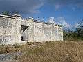 Old disused prison, Matthew Town, Great Inagua
 Window in old prison, Matthew Town, Great Inagua
 Modern police station, Matthew Town, Great Inagua
 Grocery store in Matthew Town, Great Inagua
 Part of the Morton Salt facilities on the north shore of Great Inagua
 Northern rocky shore of Great Inagua exposing Pleistocene reefal limestones
Notes
- ↑ Julian Granberry and Gary S. Vescelius. (2004) Languages of the Pre-Columbian Antilles. The University of Alabama Press. ISBN 0-8173-5123-X p. 83
- ↑ INAGUA POPULATION BY SETTLEMENT AND TOTAL NUMBER OF OCCUPIED DWELLINGS: 2010 CENSUS - Bahamas Department of Statistics
Further reading
Klingel, Gilbert. The Ocean Island (Inagua). Dodd, Mead: New York, 1940.
External links
- Great Inagua Photos, January 2006
Coordinates: 21°03′25″N 73°25′28″W / 21.05682°N 73.424377°W