Great Horwood
| Great Horwood | |
 Great Horwood |
|
| Population | 1,049 (2011 Census)[1] |
|---|---|
| OS grid reference | SP770312 |
| Civil parish | Great Horwood |
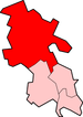
| District | Aylesbury Vale |
| Shire county | Buckinghamshire |
| Region | South East |
| Country | England |
| Sovereign state | United Kingdom |
| Post town | MILTON KEYNES |
| Postcode district | MK17 |
| Dialling code | 01296 |
| Police | Thames Valley |
| Fire | Buckinghamshire |
| Ambulance | South Central |
| EU Parliament | South East England |
| UK Parliament | Buckingham |
|
|
Coordinates: 51°58′23″N 0°52′41″W / 51.973°N 0.878°W
Great Horwood is a small village and is also a civil parish within Aylesbury Vale district in Buckinghamshire, England with a population of about 1025 people (2001 Census). It is about five miles ESE of Buckingham, six miles WSW of Milton Keynes.
The village name 'Horwood' is Anglo Saxon in origin, and means 'muddy wood'. The affix 'Great' was added later to differentiate it from the adjacent village Little Horwood. In the Anglo-Saxon Chronicle in 792 the village was recorded as Horwudu.
The village was from ancient times on the periphery of the Whaddon Chase: royal hunting land that stretched across the north part of the Aylesbury Vale. In 1447 the village was granted Royal charter to hold a weekly market, thus becoming a market town. The rents from the market were collected by New College, Oxford. Great Horwood is no longer a market town.
Great Horwood has two historic pubs: The Crown is situated on the village green and The Swan Inn on Winslow Road.
A hamlet within the parish border of Great Horwood is Singleborough.
Both Great Horwood village itself and Singleborough have Conservation Areas and there are 46 Grade II listed buildings in the Parish.
The parish church is dedicated to St James.
The village is also home to Great Horwood Church of England Combined School, which is a mixed Church of England primary school. It is a voluntary controlled school, which takes children from the age of four through to the age of eleven. The school has approximately 160 pupils. Its catchment area also includes the villages of Thornborough, Nash, Beachampton and Whaddon.
References
- ↑ Neighbourhood Statistics 2011 Census, Accessed 3 February 2013
External links
| Wikimedia Commons has media related to Great Horwood. |
- Great Horwood Church of England Combined School
- Great Horwood Football Club
- Great Horwood Silver Band
Pictures
 Entrance to Mary's?
 Great Horwood Church
 Garages in Great Horwood
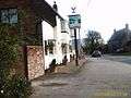 The Swan, Great Horwood
 Horses seen in the village