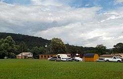
Graysville, Tennessee
| Graysville, Tennessee | |
|---|---|
| Town | |
 | |
 Location of Graysville, Tennessee | |
| Coordinates: 35°26′52″N 85°4′57″W / 35.44778°N 85.08250°WCoordinates: 35°26′52″N 85°4′57″W / 35.44778°N 85.08250°W | |
| Country | United States |
| State | Tennessee |
| County | Rhea |
| Named for | William Gray, early settler[1] |
| Area | |
| • Total | 0.8 sq mi (2.1 km2) |
| • Land | 0.8 sq mi (2.1 km2) |
| • Water | 0.0 sq mi (0.0 km2) |
| Elevation | 745 ft (227 m) |
| Population (2010) | |
| • Total | 1,502 |
| • Density | 1,877.5/sq mi (715.2/km2) |
| Time zone | Eastern (EST) (UTC-5) |
| • Summer (DST) | EDT (UTC-4) |
| ZIP code | 37338 |
| Area code(s) | 423 |
| FIPS code | 47-30760[2] |
| GNIS feature ID | 1286033[3] |
| Website |
graysvilletn |
Graysville is a town in Rhea County, Tennessee, United States. The population was 1,411 at the 2000 census and 1,502 at the 2010 census.
History
Graysville is named for William Gray, an early settler who was appointed postmaster in 1875. The town expanded in the 1880s, when the arrival of the railroad brought coal extraction industries to the area. During this period, the Dayton Coal and Iron Company established a major operation at Graysville. Coal mined nearby was converted into coke, which in turn was used to fuel two blast furnaces to produce pig iron. This operation continued until the Great Depression brought about a general collapse in the industry in the 1930s.[1]
Geography
Graysville is located at 35°26′52″N 85°4′57″W / 35.44778°N 85.08250°W (35.447848, -85.082437).[4] It is situated along Roaring Creek between Walden Ridge (an escarpment of the Cumberland Plateau) and Blackoak Ridge, just north of the Rhea-Hamilton line.[1] U.S. Route 27 passes through the eastern part of Graysville.
According to the United States Census Bureau, the town has a total area of 0.8 square miles (2.1 km2), all of it land.
Demographics
| Historical population | |||
|---|---|---|---|
| Census | Pop. | %± | |
| 1920 | 786 | — | |
| 1930 | 793 | 0.9% | |
| 1940 | 846 | 6.7% | |
| 1950 | 820 | −3.1% | |
| 1960 | 838 | 2.2% | |
| 1970 | 951 | 13.5% | |
| 1980 | 1,380 | 45.1% | |
| 1990 | 1,301 | −5.7% | |
| 2000 | 1,411 | 8.5% | |
| 2010 | 1,502 | 6.4% | |
| Est. 2015 | 1,515 | [5] | 0.9% |
| Sources:[6][7] | |||
As of the census[2] of 2000, there were 1,411 people, 551 households, and 400 families residing in the town. The population density was 1,745.1 people per square mile (672.6/km²). There were 610 housing units at an average density of 754.4 per square mile (290.8/km²). The racial makeup of the town was 97.24% White, 0.64% African American, 0.21% Native American, 0.07% Pacific Islander, 0.57% from other races, and 1.28% from two or more races. Hispanic or Latino of any race were 1.49% of the population.
There were 551 households out of which 36.7% had children under the age of 18 living with them, 50.1% were married couples living together, 17.8% had a female householder with no husband present, and 27.4% were non-families. 23.4% of all households were made up of individuals and 9.6% had someone living alone who was 65 years of age or older. The average household size was 2.56 and the average family size was 3.01.
In the town the population was spread out with 27.1% under the age of 18, 9.6% from 18 to 24, 31.3% from 25 to 44, 22.0% from 45 to 64, and 10.1% who were 65 years of age or older. The median age was 34 years. For every 100 females there were 85.7 males. For every 100 females age 18 and over, there were 81.2 males.
The median income for a household in the town was $28,370, and the median income for a family was $32,163. Males had a median income of $28,810 versus $20,885 for females. The per capita income for the town was $12,244. About 13.5% of families and 17.1% of the population were below the poverty line, including 22.3% of those under age 18 and 16.0% of those age 65 or over.
References
- 1 2 3 E. Raymond Evans, "Graysville," An Encyclopedia of East Tennessee (Children's Museum of Oak Ridge, 1981), pp. 223-224.
- 1 2 "American FactFinder". United States Census Bureau. Retrieved 2008-01-31.
- ↑ "US Board on Geographic Names". United States Geological Survey. 2007-10-25. Retrieved 2008-01-31.
- ↑ "US Gazetteer files: 2010, 2000, and 1990". United States Census Bureau. 2011-02-12. Retrieved 2011-04-23.
- ↑ "Annual Estimates of the Resident Population for Incorporated Places: April 1, 2010 to July 1, 2015". Retrieved July 2, 2016.
- ↑ "Census of Population and Housing: Decennial Censuses". United States Census Bureau. Retrieved 2012-03-04.
- ↑ "Incorporated Places and Minor Civil Divisions Datasets: Subcounty Resident Population Estimates: April 1, 2010 to July 1, 2012". Population Estimates. U.S. Census Bureau. Retrieved 11 December 2013.
External links
| Wikimedia Commons has media related to Graysville, Tennessee. |
Municipalities and communities of Rhea County, Tennessee, United States | ||
|---|---|---|
| City | ||
| Towns | ||
| Unincorporated communities | ||