Gravelly Shoal Light
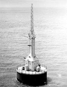 Undated USCG photo | |
 | |
| Location | Saginaw Bay, Michigan |
|---|---|
| Coordinates | 44°1′6″N 83°32′14″W / 44.01833°N 83.53722°WCoordinates: 44°1′6″N 83°32′14″W / 44.01833°N 83.53722°W |
| Year first constructed | 1939 |
| Year first lit | 1939 |
| Foundation | 50-foot (15 m) diameter concrete pier[1] |
| Construction | Steel-sided tower |
| Tower shape | Art Deco |
| Markings / pattern | white, gray scaffold atop |
| Height | Tower - 65 feet (20 m)[2] |
| Focal height | Focal plane - 75 feet (23 m)[3] |
| Current lens | 14.8-inch (375 mm) lens[4] |
| Intensity | 15,000 candela[5] |
| Range | 9.6 nautical miles; 18 kilometres (11 mi) |
| Characteristic | red flash every 6 seconds[6] |
| Fog signal |
Every 30 seconds, operates year round.[4] Radio beacon signal transmitted at 296 kilocycles, and emitted a group of 0.5 -second dashes for 15.5 seconds, followed by 14.5 seconds of silence.[5] |
| ARLHS number | USA-340[7][8] |
| USCG number | 7-10540 |
Gravelly Shoals Light is an automated lighthouse that is an active aid to navigation on the shallow shoals extending southeast from Point Lookout[9] on the western side of Saginaw Bay. The light is situated about 2.7 miles (4.3 km) offshore and was built to help guide boats through the deeper water between the southeast end of Gravelly Shoals and Charity Island. Architecturally this is considered to be Art Deco style.[10]
History
As part of President Roosevelt's New Deal and its program to "Put America Back to Work" the new light tower was put up for bid, and built in 1939.[11] It replaced an earlier gas-lit buoy. It also displaced the Charity Island Light,[12] which was constructed in 1857, and operated until 1930.[5]
Contemporary unmanned lights in the Art Deco style is the Indiana Harbor East Breakwater Light and its twin, the better known Port Washington Breakwater Light in Wisconsin.[13][14]
When built according to its original specifications, the contractor warned that the foundation was inadequate to withstand the buildup of ice, and put in a bid for a contract modification. However, at the time jurisdiction over the light had just been transferred to the Coast Guard from the United States Lighthouse Service, and they chose to disregard the warning, and to accept the light as built. This resulted in substantial additional expense in due course, as the light had to be retrofitted.[5]
This light is designed as an autonomous automated electrified station. It is under the control and maintenance of Coast Guard Station in Tawas City, Michigan. Ordinarily it displays a 15,000 candela 14.8 inches (375 mm) light powered by a 120 volt electric lamp. Power is supplied through a submarine cable, which crosses the shoal from Point Lookout. The 75-foot (23 m) focal plane makes its flash (1-second every 5 seconds) visible for 14 nautical miles; 26 kilometres (16 mi). It is supplemented by a standby 110 candela acetylene light with a half second flash every three seconds—which activates automatically if there is a power failure. In foggy weather, mariners are warned by twin compressed-air two-tone #3 diaphones, which operate on a 30-second cycle (3-second blast followed by 27 seconds of silence).[5]
The National Data Buoy Center lists the Site Elevation as 588 feet (179.2 m) above sea level; an automatic readout for wind, waves and weather is operated there.[15]
The National Weather Service operates an automated weather observing station at the lighthouse.
An added large steel tower atop the light is a radio beacon. The 1953 Coast Guard Light List indicates that the signal transmitted at 296 kilocycles, send forth a group of half-second dashes for 15.5 seconds, followed by 14½ seconds of silence. As of 2001, both the light and radio beacon served as active navigational aids.[5]
Although it never had a resident lighthouse keeper, this light is a recognized 'significant light" by the National Park Service National Maritime Initiative.[16]
As of July, 2015, the light is for sale through an on line GSA auction process.[17][18][19]
Getting there
A good passing view of the light can be had while riding the ferry from Au Gres to Charity Island, which is 10 miles (16 km) to the east in the middle of Saginaw Bay.[20] Tours of Charity Island (and even dinner cruises) are available, which can include the privately owned, rebuilt Charity Island Light lightkeeper's house. They are available from Charity Island Transport, Inc. in Au Gres, Michigan on the mainland, south of Tawas.[21]
It is also possible to take a telephoto shot from shore.
![]() US 23 north from Au Gres, 4.8 miles (7.7 km) to Point Lookout Road. Turn right to its end; turn left onto Michigan Ave. Through a break in the houses one can see Saginaw Bay and the light.[22]
US 23 north from Au Gres, 4.8 miles (7.7 km) to Point Lookout Road. Turn right to its end; turn left onto Michigan Ave. Through a break in the houses one can see Saginaw Bay and the light.[22]
See also
Notes
- ↑ Detroit News , Interactive map on Michigan lighthouses.
- ↑ Pepper, Terry. "Database of Tower Heights". Seeing the Light. terrypepper.com.
- ↑ Pepper, Terry. "Database of Focal Heights". Seeing the Light. terrypepper.com.
- 1 2 Rowlett, Russ. "Lighthouses of the United States: Michigan's Eastern Lower Peninsula". The Lighthouse Directory. University of North Carolina at Chapel Hill.
- 1 2 3 4 5 6 Terry Pepper, Seeing the Light, Gravelly Shoal Light.
- ↑ Light List, Volume VII, Great Lakes (PDF). Light List. United States Coast Guard.
- ↑ Amateur Radio Lighthouse Society, Gravelly Shoal (Lake Huron)Light ARLHS USA-340
- ↑ Amateur Radio Lighthouse Society, World List of Lights (WLOL).
- ↑ Wobser, Dave, Gravelly Shoal Light, at boatnerd.com.
- ↑ Lighthouse Depot, Gravelly Shoal light. Archived December 29, 2004, at the Wayback Machine.
- ↑ Lighthouse Central, Gravelly Shoal Light Photographs, History and Directions, The Ultimate Guide to East Michigan Lighthouses by Jerry Roach (Publisher: Bugs Publishing LLC - July 2006). ISBN 0-9747977-1-5; ISBN 978-0-9747977-1-7.
- ↑ Bostwick, Violet M., Charity Island Light, Boatnerd.com.
- ↑ "Historic Light Station Information and Photography: Indiana". United States Coast Guard Historian's Office. Retrieved 2008-11-24. Note that the document has a picture of the Indiana Harbor East Breakwater Light under "Indiana Harbor Light", and that it has the correct history and wrong picture under "Indiana Harbor East Breakwater Light"
- ↑ Rowlett, Russ. "Lighthouses of the United States: Indiana". The Lighthouse Directory. University of North Carolina at Chapel Hill.
- ↑ National Buoy Data Center with automatic readout of wind, waves and weather for Gravelly Shoal Light.
- ↑ National Park Service Maritime History Project, Inventory of Historic Light Stations. Significant Unmanned Aids.
- ↑ "Summer 2015 Lighthouse Sales Be a Part of Maritime History Zone One—Boston/Chicago". General Services Administration. Retrieved July 14, 2015.
- ↑ "Gravelly Shoal Light Auction". General Services Administration. Retrieved July 14, 2015.
- ↑ Daniels, Serena Maria; Klayman, Ed., Ben; Walsh, Eric, Ed. (July 15, 2015). "For sale: three Michigan lighthouses, to caring owners". Detroit: Reuters. Retrieved July 14, 2015.
- ↑ Lighthouse Depot, Gravelly Shoal Light/Charity Island. Archived December 29, 2004, at the Wayback Machine.
- ↑ Charity Island ferry service.
- ↑ us-lighthouses.com on Gravelly Shoal Light.
Further reading
- Bibliography on Michigan lighthouses.
- Detroit News Interactive map on Michigan lighthouses.
- Great Lakes Light Keepers Association.
- Great Lakes Lighthouse Resources, Great Lakes Light Keepers Association.
- Harrison, Tim (editor of Lighthouse Digest and President of the American Lighthouse Foundation), (September, 2009) Ghost Lights of Michigan (Rare historic images and text on Michigan's lost and obscure lighthouse, including bonus chapters on lightships and lighthouse tenders.) East Machias, Maine: Foghorn Publishing, ISBN 978-0-9778293-3-0.
- Hyde, Charles K., and Ann and John Mahan. The Northern Lights: Lighthouses of the Upper Great Lakes. Detroit: Wayne State University Press, 1995. ISBN 0-8143-2554-8 ISBN 9780814325544.
- Map of Michigan Lighthouse in PDF Format.
- Michigan Light List. Michigan Lighthouse Conservancy.
- Map of Michigan Lighthouses. Michigan Lighthouse Fund.
- Michigan Lighthouse Conservancy.
- Oleszewski, Wes, Great Lakes Lighthouses, American and Canadian: A Comprehensive Directory/Guide to Great Lakes Lighthouses, (Gwinn, Michigan: Avery Color Studios, Inc., 1998) ISBN 0-932212-98-0.
- Penrod, John. Lighthouses of Michigan, (Berrien Center, Michigan: Penrod/Hiawatha, 1998) ISBN 978-0-942618-78-5 ISBN 9781893624238.
- Penrose, Laurie and Penrose, Bill Traveler's Guide to 116 Michigan Lighthouses, Petoskey, Michigan: Friede Publications, 1999. ISBN 0-923756-03-5 ISBN 9780923756031.
- Pepper, Terry, President Great Lakes Lightkeepers Association, Seeing the Light: Lighthouses on the western Great Lakes
- Roach, Jerry. Lighthouse Central, Michigan Lighthouses.
- The Ultimate Guide to East Michigan Lighthouses. Bugs Publishing, 2006. ISBN 0-9747977-1-5; ISBN 978-0-9747977-1-7.
- The Ultimate Guide to Upper Michigan Lighthouses. Bugs Publishing, 2007. ISBN 978-0-9747977-2-4.
- The Ultimate Guide to West Michigan Lighthouses. Bugs Publishing, 2005. ISBN 0-9747977-0-7.
- Sapulski, Wayne S., (2001) Lighthouses of Lake Michigan: Past and Present (Paperback) (Fowlerville: Wilderness Adventure Books) ISBN 0-923568-47-6; ISBN 978-0-923568-47-4.
- Splake, T. Kilgore. Superior Land Lights. Battle Creek, MI: Angst Productions, 1984.
- "Historic Light Station Information and Photography: Michigan". United States Coast Guard Historian's Office.
- Wagner, John L. "Beacons Shining in the Night: The Lighthouses of Michigan". Clarke Historical Library, Central Michigan University.
- Wagner, John L., Michigan Lighthouses: An Aerial Photographic Perspective, (East Lansing, Michigan: John L. Wagner, 1998) ISBN 1-880311-01-1 ISBN 9781880311011.
- Wargin, Ed, Legends of Light: A Michigan Lighthouse Portfolio. Ann Arbor Media Group, 2006. ISBN 978-1-58726-251-7.
- Wobser, David, Lighthouses of the Great Lakes, boatnerd.com.
- Wright, Larry and Wright, Patricia, Great Lakes Lighthouses Encyclopedia Boston Mills Press, 2006. ISBN 1-55046-399-3.
External links
- Interactive map of lighthouses in area by LighthousesRus
- Map of Michigan Lighthouses from Michigan.gov
- Michigan lighthouse conservancy, Gravelly Shoal Light
- National Buoy Data Center with automatic readout of wind, waves and weather for Gravelly Shoal Light.
- Photograph of Coast Guard boat at Gravelly Shoal, circa 1942, Archives of Michigan.
- Photos of Gravelly Shoal Light (current) from ferry
| Northern Upper Peninsula |
|  |
|---|---|---|
| Southern Upper Peninsula | ||
| St. Mary's River |
| |
| Portage River/Ship Canal |
| |
| Straits of Mackinac | ||
| Western Lower Peninsula |
| |
| Eastern Lower Peninsula |
| |
| Historical (lost) lights |
| |
| Related | ||